| |
Kingdom of the Netherlands
|
| Capital |
Currency | Government system |
|---|
| Amsterdam |
Euro (EUR) |
Constitutional hereditary monarchy |
| Official language | Region |
Population |
|---|
| Dutch |
Europe |
Estimation 2026 - 18 045 532 |
Country map - Administrative structure - Population density of Netherlands
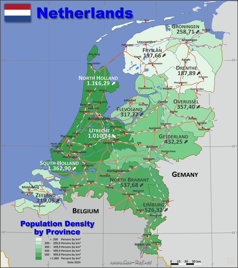
Netherlands - Click on the map to get a enlarged image in PDF format!
Other language versions are easy to generate, the description is in an own layer
Conditions for thematic maps with your own data and logotype
Delivery as printable file by e-mail or plot by post office |
|---|
| Layer | |
| Province: | yes |
| Streets: | yes |
| Infrastructure: | yes |
| Rivers: | yes |
|
| Size | bis A2 |
| Supply in | 7 working days |
| Price |
| 1 bis 3 | 70 € |
| > 3 | On request |
|
 |
All information published herein is free usable quoting the source,
including the maps, if they are not modified |
|---|
Statistical Data - Population density according to the administrative structure
The population data in the table below is an estimation for 2026, based on the census data from 2001.
Click on the column header brings the table in order of the column header. The default order is the Province name.
| Province |
ISO
3166-2 |
Capital |
Area
(km²) |
Population |
Density
(pers/km²) |
|---|
| Total |
|
|
33 809 |
18 045 532 |
533,75 |
|---|
| Last update: 02/01/2021 - 14:16:52 |
| Drenthe |
NL-DR |
Assen |
2 683 |
506 612 |
188,82 |
| Flevoland |
NL-FL |
Lelystad |
1 419 |
456 446 |
321,67 |
| Fryslân |
NL-FY |
Leeuwarden |
3 349 |
664 234 |
198,34 |
| Gelderland |
NL-GE |
Arnhem |
4 972 |
2 161 388 |
434,73 |
| Groningen |
NL-GR |
Groningen |
2 325 |
603 256 |
259,46 |
| Limburg |
NL-LI |
Maastricht |
2 153 |
1 135 506 |
527,41 |
| North Brabant |
NL-NB |
Hertogenbosch |
4 919 |
2 664 364 |
541,65 |
| North Holland |
NL-NH |
Haarlem |
2 670 |
2 993 088 |
1 121,01 |
| Overijssel |
NL-OV |
Zwolle |
3 327 |
1 195 792 |
359,42 |
| South Holland |
NL-ZH |
The Hague |
2 818 |
3 862 920 |
1 370,80 |
| Utrecht |
NL-UT |
Utrecht |
1 386 |
1 408 878 |
1 016,51 |
| Zeeland |
NL-ZE |
Middelburg |
1 788 |
393 048 |
219,83 |
The provinces are subdivided into municipalities, and their data can be found in the following table.shown below.
| Municipality |
Own |
Province |
Capital |
Area
(km²) |
Population |
Density
(pers/km²) |
|---|
| Total |
|
|
|
33 647,9 |
18 131 238 |
538,9 |
|---|
| Last update: 02/01/2021 - 14:16:52 |
| Aa en Hunze |
NL-DR-01 |
Drenthe |
Gieten |
276,1 |
26 057 |
94,4 |
| Aalsmeer |
NL-NH-01 |
North Holland |
Aalsmeer |
20,1 |
33 453 |
1 664,3 |
| Aalten |
NL-GE-01 |
Gelderland |
Aalten |
96,5 |
27 603 |
286,0 |
| Achtkarspelen |
NL-FY-01 |
Fryslan |
Buitenpost |
102,2 |
28 253 |
276,4 |
| Alblasserdam |
NL-ZH-01 |
South Holland |
Alblasserdam |
8,8 |
20 239 |
2 299,9 |
| Albrandswaard |
NL-ZH-02 |
South Holland |
Poortugaal |
21,7 |
26 560 |
1 224,0 |
| Alkmaar |
NL-NH-02 |
North Holland |
Alkmaar |
110,3 |
113 170 |
1 026,0 |
| Almelo |
NL-OV-01 |
Overijssel |
Almelo |
67,2 |
75 158 |
1 118,4 |
| Almere |
NL-FL-01 |
Flevoland |
Almere Stad |
129,2 |
232 650 |
1 800,7 |
| Alphen aan den Rijn |
NL-ZH-03 |
South Holland |
Alphen aan den Rijn |
125,9 |
117 278 |
931,5 |
| Alphen-Chaam |
NL-NB-01 |
North Brabant |
Alphen |
93,0 |
10 489 |
112,8 |
| Altena |
NL-NB-02 |
North Brabant |
Almkerk |
199,7 |
58 957 |
295,2 |
| Ameland |
NL-FY-02 |
Fryslan |
Ballum |
56,6 |
3 822 |
67,5 |
| Amersfoort |
NL-UT-01 |
Utrecht |
Amersfoort |
62,5 |
163 766 |
2 620,3 |
| Amstelveen |
NL-NH-03 |
North Holland |
Amstelveen |
41,1 |
95 836 |
2 331,8 |
| Amsterdam |
NL-NH-04 |
North Holland |
Amsterdam |
188,1 |
942 504 |
5 010,7 |
| Apeldoorn |
NL-GE-02 |
Gelderland |
Apeldoorn |
339,9 |
169 222 |
497,9 |
| Arnhem |
NL-GE-03 |
Gelderland |
Arnhem |
97,7 |
172 002 |
1 760,5 |
| Assen |
NL-DR-02 |
Drenthe |
Assen |
81,9 |
70 765 |
864,0 |
| Asten |
NL-NB-03 |
North Brabant |
Asten |
70,2 |
17 493 |
249,2 |
| Baarle-Nassau |
NL-NB-04 |
North Brabant |
Baarle |
76,1 |
7 254 |
95,3 |
| Baarn |
NL-UT-02 |
Utrecht |
Baarn |
32,5 |
25 442 |
782,8 |
| Barendrecht |
NL-ZH-04 |
South Holland |
Barendrecht |
19,6 |
48 678 |
2 483,6 |
| Barneveld |
NL-GE-04 |
Gelderland |
Barneveld |
175,8 |
63 927 |
363,6 |
| Beek |
NL-LI-01 |
Limburg |
Beek |
21,1 |
16 143 |
765,1 |
| Beekdaelen |
NL-LI-02 |
Limburg |
Nuth |
78,3 |
35 915 |
458,7 |
| Beesel |
NL-LI-03 |
Limburg |
Beesel |
27,9 |
13 569 |
486,3 |
| Berg en Dal |
NL-GE-05 |
Gelderland |
Groesbeek |
86,4 |
35 706 |
413,3 |
| Bergeijk |
NL-NB-05 |
North Brabant |
Bergeijk |
101,0 |
19 440 |
192,5 |
| Bergen |
NL-LI-04 |
Limburg |
Nieuw Bergen |
103,3 |
13 038 |
126,2 |
| Bergen |
NL-NH-05 |
North Holland |
Bergen |
99,0 |
29 654 |
299,5 |
| Bergen op Zoom |
NL-NB-06 |
North Brabant |
Bergen op Zoom |
80,0 |
70 693 |
883,7 |
| Berkelland |
NL-GE-06 |
Gelderland |
Borculo |
258,1 |
43 990 |
170,4 |
| Bernheze |
NL-NB-07 |
North Brabant |
Heesch |
89,7 |
32 943 |
367,3 |
| Best |
NL-NB-08 |
North Brabant |
Best |
33,9 |
31 694 |
934,9 |
| Beuningen |
NL-GE-07 |
Gelderland |
Beuningen |
43,6 |
26 871 |
616,3 |
| Beverwijk |
NL-NH-06 |
North Holland |
Beverwijk |
18,4 |
43 063 |
2 340,4 |
| Bladel |
NL-NB-09 |
North Brabant |
Bladel |
75,3 |
21 046 |
279,5 |
| Blaricum |
NL-NH-07 |
North Holland |
Blaricum |
11,1 |
12 934 |
1 165,2 |
| Bloemendaal |
NL-NH-08 |
North Holland |
Overveen |
39,8 |
23 558 |
591,9 |
| Bodegraven-Reeuwijk |
NL-ZH-05 |
South Holland |
Bodegraven |
75,4 |
37 292 |
494,6 |
| Boekel |
NL-NB-10 |
North Brabant |
Boekel |
34,5 |
11 685 |
338,7 |
| Borger-Odoorn |
NL-DR-03 |
Drenthe |
Exloo |
274,7 |
26 161 |
95,2 |
| Borne |
NL-OV-02 |
Overijssel |
Borne |
26,0 |
25 042 |
963,2 |
| Borsele |
NL-ZE-01 |
Zeeland |
Heinkenszand |
141,5 |
23 185 |
163,9 |
| Boxtel |
NL-NB-11 |
North Brabant |
Boxtel |
69,0 |
34 314 |
497,3 |
| Breda |
NL-NB-12 |
North Brabant |
Breda |
125,7 |
190 171 |
1 512,9 |
| Bronckhorst |
NL-GE-08 |
Gelderland |
Hengelo |
283,5 |
35 981 |
126,9 |
| Brummen |
NL-GE-09 |
Gelderland |
Brummen |
83,6 |
21 561 |
257,9 |
| Brunssum |
NL-LI-05 |
Limburg |
Brunssum |
17,2 |
27 481 |
1 597,7 |
| Bunnik |
NL-UT-03 |
Utrecht |
Bunnik |
37,0 |
16 402 |
443,3 |
| Bunschoten |
NL-UT-04 |
Utrecht |
Bunschoten-Spakenburg |
30,4 |
22 899 |
753,3 |
| Buren |
NL-GE-10 |
Gelderland |
Maurik |
133,6 |
28 096 |
210,3 |
| Capelle aan den IJssel |
NL-ZH-06 |
South Holland |
Capelle aan den IJssel |
14,1 |
69 644 |
4 939,3 |
| Castricum |
NL-NH-09 |
North Holland |
Castricum |
49,6 |
37 075 |
747,5 |
| Coevorden |
NL-DR-04 |
Drenthe |
Coevorden |
296,1 |
35 726 |
120,7 |
| Cranendonck |
NL-NB-13 |
North Brabant |
Budel |
76,5 |
21 025 |
274,8 |
| Culemborg |
NL-GE-11 |
Gelderland |
Culemborg |
29,3 |
30 409 |
1 037,8 |
| Dalfsen |
NL-OV-03 |
Overijssel |
Dalfsen |
165,0 |
30 268 |
183,4 |
| Dantumadiel |
NL-FY-03 |
Fryslan |
Damwald |
84,6 |
19 241 |
227,4 |
| De Bilt |
NL-UT-05 |
Utrecht |
Bilthoven & De Bilt |
66,2 |
43 673 |
659,7 |
| De Fryske Marren |
NL-FY-04 |
Fryslan |
Joure |
351,2 |
52 253 |
148,8 |
| De Ronde Venen |
NL-UT-06 |
Utrecht |
Mijdrecht |
99,7 |
45 739 |
458,8 |
| De Wolden |
NL-DR-05 |
Drenthe |
Zuidwolde |
224,4 |
24 826 |
110,6 |
| Delft |
NL-ZH-07 |
South Holland |
Delft |
22,7 |
110 044 |
4 847,8 |
| Den Helder |
NL-NH-10 |
North Holland |
Den Helder |
45,1 |
56 665 |
1 256,4 |
| Deurne |
NL-NB-14 |
North Brabant |
Deurne |
116,8 |
33 597 |
287,6 |
| Deventer |
NL-OV-04 |
Overijssel |
Deventer |
130,6 |
105 130 |
805,0 |
| Diemen |
NL-NH-11 |
North Holland |
Diemen |
12,0 |
33 284 |
2 773,7 |
| Dijk en Waard |
NL-NH-12 |
North Holland |
Heerhugowaard |
61,9 |
91 431 |
1 477,1 |
| Dinkelland |
NL-OV-05 |
Overijssel |
Denekamp |
175,7 |
26 969 |
153,5 |
| Doesburg |
NL-GE-12 |
Gelderland |
Doesburg |
11,6 |
11 172 |
963,1 |
| Doetinchem |
NL-GE-13 |
Gelderland |
Doetinchem |
79,0 |
60 473 |
765,5 |
| Dongen |
NL-NB-15 |
North Brabant |
Dongen |
29,2 |
27 607 |
945,4 |
| Dordrecht |
NL-ZH-08 |
South Holland |
Dordrecht |
77,6 |
122 933 |
1 584,2 |
| Drechterland |
NL-NH-13 |
North Holland |
Hoogkarspel |
58,9 |
20 553 |
348,9 |
| Drimmelen |
NL-NB-16 |
North Brabant |
Made |
95,1 |
28 399 |
298,6 |
| Dronten |
NL-FL-02 |
Flevoland |
Dronten |
333,6 |
45 436 |
136,2 |
| Druten |
NL-GE-14 |
Gelderland |
Druten |
37,5 |
20 015 |
533,7 |
| Duiven |
NL-GE-15 |
Gelderland |
Duiven |
33,9 |
24 856 |
733,2 |
| Echt-Susteren |
NL-LI-06 |
Limburg |
Echt |
103,0 |
32 394 |
314,5 |
| Edam-Volendam |
NL-NH-14 |
North Holland |
Volendam |
54,3 |
37 124 |
683,7 |
| Ede |
NL-GE-16 |
Gelderland |
Ede |
318,1 |
125 303 |
393,9 |
| Eemnes |
NL-UT-07 |
Utrecht |
Eemnes |
31,0 |
10 063 |
324,6 |
| Eemsdelta |
NL-GR-01 |
Groningen |
Appingedam/Delfzijl |
268,1 |
44 841 |
167,3 |
| Eersel |
NL-NB-17 |
North Brabant |
Eersel |
82,5 |
20 539 |
249,0 |
| Eijsden-Margraten |
NL-LI-07 |
Limburg |
Margraten |
77,6 |
26 346 |
339,5 |
| Eindhoven |
NL-NB-18 |
North Brabant |
Eindhoven |
88,0 |
249 873 |
2 839,5 |
| Elburg |
NL-GE-17 |
Gelderland |
Elburg |
63,8 |
24 039 |
376,8 |
| Emmen |
NL-DR-06 |
Drenthe |
Emmen |
335,3 |
109 838 |
327,6 |
| Enkhuizen |
NL-NH-15 |
North Holland |
Enkhuizen |
12,7 |
18 738 |
1 475,4 |
| Enschede |
NL-OV-06 |
Overijssel |
Enschede |
140,7 |
162 671 |
1 156,2 |
| Epe |
NL-GE-18 |
Gelderland |
Epe |
156,1 |
33 781 |
216,4 |
| Ermelo |
NL-GE-19 |
Gelderland |
Ermelo |
85,6 |
28 191 |
329,3 |
| Etten-Leur |
NL-NB-19 |
North Brabant |
Etten-Leur |
55,3 |
46 109 |
833,8 |
| Geertruidenberg |
NL-NB-20 |
North Brabant |
Geertruidenberg |
26,6 |
21 914 |
823,8 |
| Geldrop-Mierlo |
NL-NB-21 |
North Brabant |
Geldrop |
31,0 |
40 683 |
1 312,4 |
| Gemert-Bakel |
NL-NB-22 |
North Brabant |
Gemert |
122,1 |
31 812 |
260,5 |
| Gennep |
NL-LI-08 |
Limburg |
Gennep |
47,6 |
17 957 |
377,2 |
| Gilze en Rijen |
NL-NB-23 |
North Brabant |
Rijen |
65,4 |
28 361 |
433,7 |
| Goeree-Overflakkee |
NL-ZH-09 |
South Holland |
Middelharnis |
262,2 |
52 775 |
201,3 |
| Goes |
NL-ZE-02 |
Zeeland |
Goes |
92,5 |
40 399 |
436,7 |
| Goirle |
NL-NB-24 |
North Brabant |
Goirle |
43,0 |
24 891 |
578,9 |
| Gooise Meren |
NL-NH-16 |
North Holland |
Bussum |
41,4 |
61 213 |
1 478,6 |
| Gorinchem |
NL-ZH-10 |
South Holland |
Gorinchem |
18,7 |
39 046 |
2 088,0 |
| Gouda |
NL-ZH-11 |
South Holland |
Gouda |
16,5 |
77 803 |
4 715,3 |
| Groningen |
NL-GR-02 |
Groningen |
Groningen |
185,5 |
244 829 |
1 319,8 |
| Gulpen-Wittem |
NL-LI-09 |
Limburg |
Gulpen |
73,2 |
13 944 |
190,5 |
| Haaksbergen |
NL-OV-07 |
Overijssel |
Haaksbergen |
104,8 |
24 313 |
232,0 |
| Haarlem |
NL-NH-17 |
North Holland |
Haarlem |
29,2 |
168 946 |
5 785,8 |
| Haarlemmermeer |
NL-NH-18 |
North Holland |
Hoofddorp |
197,2 |
166 996 |
846,8 |
| Halderberge |
NL-NB-25 |
North Brabant |
Oudenbosch |
74,4 |
31 477 |
423,1 |
| Hardenberg |
NL-OV-08 |
Overijssel |
Hardenberg |
312,2 |
64 120 |
205,4 |
| Harderwijk |
NL-GE-20 |
Gelderland |
Harderwijk |
38,9 |
50 661 |
1 302,3 |
| Hardinxveld-Giessendam |
NL-ZH-12 |
South Holland |
Neder-Hardinxveld |
16,9 |
19 400 |
1 147,9 |
| Harlingen |
NL-FY-05 |
Fryslan |
Harlingen |
25,0 |
16 270 |
650,8 |
| Hattem |
NL-GE-21 |
Gelderland |
Hattem |
23,1 |
12 822 |
555,1 |
| Heemskerk |
NL-NH-19 |
North Holland |
Heemskerk |
27,3 |
39 532 |
1 448,1 |
| Heemstede |
NL-NH-20 |
North Holland |
Heemstede |
9,2 |
27 557 |
2 995,3 |
| Heerde |
NL-GE-22 |
Gelderland |
Heerde |
78,6 |
19 325 |
245,9 |
| Heerenveen |
NL-FY-06 |
Fryslan |
Heerenveen |
190,0 |
51 961 |
273,5 |
| Heerlen |
NL-LI-10 |
Limburg |
Heerlen |
44,9 |
87 754 |
1 954,4 |
| Heeze-Leende |
NL-NB-26 |
North Brabant |
Heeze |
103,9 |
17 271 |
166,2 |
| Heiloo |
NL-NH-21 |
North Holland |
Heiloo |
18,7 |
24 612 |
1 316,1 |
| Hellendoorn |
NL-OV-09 |
Overijssel |
Nijverdal |
137,9 |
36 351 |
263,6 |
| Helmond |
NL-NB-27 |
North Brabant |
Helmond |
53,2 |
96 842 |
1 820,3 |
| Hendrik-Ido-Ambacht |
NL-ZH-13 |
South Holland |
Hendrik-Ido-Ambacht |
10,2 |
33 107 |
3 245,8 |
| Hengelo |
NL-OV-10 |
Overijssel |
Hengelo |
60,8 |
84 038 |
1 382,2 |
| Het Hogeland |
NL-GR-03 |
Groningen |
Winsum |
476,7 |
48 074 |
100,8 |
| Heumen |
NL-GE-23 |
Gelderland |
Malden |
39,7 |
16 977 |
427,6 |
| Heusden |
NL-NB-28 |
North Brabant |
Vlijmen |
78,9 |
46 687 |
591,7 |
| Hillegom |
NL-ZH-14 |
South Holland |
Hillegom |
12,9 |
23 083 |
1 789,4 |
| Hilvarenbeek |
NL-NB-29 |
North Brabant |
Hilvarenbeek |
94,9 |
16 313 |
171,9 |
| Hilversum |
NL-NH-22 |
North Holland |
Hilversum |
45,6 |
94 601 |
2 074,6 |
| Hoeksche Waard |
NL-ZH-15 |
South Holland |
Oud-Beijerland/Maasdam |
268,5 |
91 448 |
340,6 |
| Hof van Twente |
NL-OV-11 |
Overijssel |
Goor |
212,4 |
35 773 |
168,4 |
| Hollands Kroon |
NL-NH-23 |
North Holland |
Anna Pawlowna |
357,6 |
50 619 |
141,6 |
| Hoogeveen |
NL-DR-07 |
Drenthe |
Hoogeveen |
127,5 |
56 773 |
445,3 |
| Hoorn |
NL-NH-24 |
North Holland |
Hoorn |
20,4 |
76 211 |
3 735,8 |
| Horst aan de Maas |
NL-LI-11 |
Limburg |
Horst aan de Maas |
188,7 |
44 805 |
237,4 |
| Houten |
NL-UT-08 |
Utrecht |
Houten |
54,9 |
50 950 |
928,1 |
| Huizen |
NL-NH-25 |
North Holland |
Huizen |
15,8 |
41 283 |
2 612,8 |
| Hulst |
NL-ZE-03 |
Zeeland |
Hulst |
201,3 |
27 375 |
136,0 |
| IJsselstein |
NL-UT-09 |
Utrecht |
IJsselstein |
21,0 |
33 171 |
1 579,6 |
| Kaag en Braassem |
NL-ZH-16 |
South Holland |
Roelofarendsveen |
63,1 |
29 472 |
467,1 |
| Kampen |
NL-OV-12 |
Overijssel |
Kampen |
141,2 |
56 841 |
402,6 |
| Kapelle |
NL-ZE-04 |
Zeeland |
Kapelle |
37,1 |
13 156 |
354,6 |
| Katwijk |
NL-ZH-17 |
South Holland |
Katwijk |
24,8 |
67 154 |
2 707,8 |
| Kerkrade |
NL-LI-12 |
Limburg |
Kerkrade |
21,9 |
45 823 |
2 092,4 |
| Koggenland |
NL-NH-26 |
North Holland |
De Goorn |
80,3 |
24 209 |
301,5 |
| Krimpen aan den IJssel |
NL-ZH-18 |
South Holland |
Krimpen |
7,7 |
29 869 |
3 879,1 |
| Krimpenerwaard |
NL-ZH-19 |
South Holland |
Stolwijk |
148,3 |
57 894 |
390,4 |
| Laarbeek |
NL-NB-30 |
North Brabant |
Beek en Donk |
55,4 |
23 543 |
425,0 |
| Land van Cuijk |
NL-NB-31 |
North Brabant |
Boxmeer |
341,3 |
93 661 |
274,4 |
| Landgraaf |
NL-LI-13 |
Limburg |
Landgraaf |
24,6 |
36 838 |
1 497,5 |
| Landsmeer |
NL-NH-27 |
North Holland |
Landsmeer |
22,4 |
11 684 |
521,6 |
| Lansingerland |
NL-ZH-20 |
South Holland |
Bergschenhoek |
53,3 |
66 613 |
1 249,8 |
| Laren |
NL-NH-28 |
North Holland |
Laren |
12,4 |
11 545 |
931,0 |
| Leeuwarden |
NL-FY-07 |
Fryslan |
Leeuwarden |
237,6 |
130 179 |
547,9 |
| Leiden |
NL-ZH-21 |
South Holland |
Leiden |
21,9 |
130 302 |
5 949,9 |
| Leiderdorp |
NL-ZH-22 |
South Holland |
Leiderdorp |
11,5 |
27 946 |
2 430,1 |
| Leidschendam-Voorburg |
NL-ZH-23 |
South Holland |
Leidschendam |
32,6 |
78 915 |
2 420,7 |
| Lelystad |
NL-FL-03 |
Flevoland |
Lelystad |
229,0 |
85 758 |
374,5 |
| Leudal |
NL-LI-14 |
Limburg |
Heythuysen |
162,5 |
36 110 |
222,2 |
| Leusden |
NL-UT-10 |
Utrecht |
Leusden |
58,5 |
32 288 |
551,9 |
| Lingewaard |
NL-GE-24 |
Gelderland |
Bemmel |
62,0 |
47 804 |
771,0 |
| Lisse |
NL-ZH-24 |
South Holland |
Lisse |
15,7 |
23 843 |
1 518,7 |
| Lochem |
NL-GE-25 |
Gelderland |
Lochem |
213,1 |
34 213 |
160,5 |
| Loon op Zand |
NL-NB-32 |
North Brabant |
Kaatsheuvel |
50,0 |
24 112 |
482,2 |
| Lopik |
NL-UT-11 |
Utrecht |
Lopik |
75,6 |
14 796 |
195,7 |
| Losser |
NL-OV-13 |
Overijssel |
Losser |
98,7 |
23 465 |
237,7 |
| Maasdriel |
NL-GE-26 |
Gelderland |
Kerkdriel |
65,9 |
26 225 |
398,0 |
| Maasgouw |
NL-LI-15 |
Limburg |
Heel |
45,7 |
24 381 |
533,5 |
| Maashorst |
NL-NB-33 |
North Brabant |
Uden |
137,3 |
60 060 |
437,4 |
| Maassluis |
NL-ZH-25 |
South Holland |
Maassluis |
8,4 |
37 136 |
4 421,0 |
| Maastricht |
NL-LI-16 |
Limburg |
Maastricht |
55,8 |
126 017 |
2 258,4 |
| Medemblik |
NL-NH-29 |
North Holland |
Wognum |
121,2 |
46 328 |
382,2 |
| Meerssen |
NL-LI-17 |
Limburg |
Meerssen |
26,7 |
18 453 |
691,1 |
| Meierijstad |
NL-NB-34 |
North Brabant |
Veghel |
184,0 |
85 249 |
463,3 |
| Meppel |
NL-DR-08 |
Drenthe |
Meppel |
55,5 |
36 607 |
659,6 |
| Middelburg |
NL-ZE-05 |
Zeeland |
Middelburg |
48,4 |
50 438 |
1 042,1 |
| Midden-Delfland |
NL-ZH-26 |
South Holland |
Schipluiden |
47,2 |
19 359 |
410,1 |
| Midden-Drenthe |
NL-DR-09 |
Drenthe |
Beilen |
340,6 |
34 404 |
101,0 |
| Midden-Groningen |
NL-GR-04 |
Groningen |
Hoogezand |
277,9 |
61 350 |
220,8 |
| Moerdijk |
NL-NB-35 |
North Brabant |
Zevenbergen |
159,2 |
38 470 |
241,6 |
| Molenlanden |
NL-ZH-27 |
South Holland |
Bleskensgraaf |
181,6 |
45 618 |
251,2 |
| Montferland |
NL-GE-27 |
Gelderland |
Didam |
105,7 |
37 008 |
350,1 |
| Montfoort |
NL-UT-12 |
Utrecht |
Montfoort |
37,6 |
13 793 |
366,8 |
| Mook en Middelaar |
NL-LI-18 |
Limburg |
Mook |
17,4 |
8 190 |
470,7 |
| Neder-Betuwe |
NL-GE-28 |
Gelderland |
Opheusden |
60,0 |
25 920 |
432,0 |
| Nederweert |
NL-LI-19 |
Limburg |
Nederweert |
99,9 |
17 537 |
175,5 |
| Nieuwegein |
NL-UT-13 |
Utrecht |
Nieuwegein |
23,4 |
68 299 |
2 918,8 |
| Nieuwkoop |
NL-ZH-28 |
South Holland |
Nieuwveen |
78,5 |
29 719 |
378,6 |
| Nijkerk |
NL-GE-29 |
Gelderland |
Nijkerk |
69,3 |
46 276 |
667,8 |
| Nijmegen |
NL-GE-30 |
Gelderland |
Nijmegen |
52,8 |
189 850 |
3 595,6 |
| Nissewaard |
NL-ZH-29 |
South Holland |
Spijkenisse |
73,3 |
89 111 |
1 215,7 |
| Noardeast-Fryslan |
NL-FY-08 |
Fryslan |
Dokkum |
379,2 |
45 933 |
121,1 |
| Noord-Beveland |
NL-ZE-06 |
Zeeland |
Wissenkerke |
86,0 |
8 071 |
93,8 |
| Noordenveld |
NL-DR-10 |
Drenthe |
Roden |
199,0 |
31 737 |
159,5 |
| Noordoostpolder |
NL-FL-04 |
Flevoland |
Emmeloord |
458,1 |
51 997 |
113,5 |
| Noordwijk |
NL-ZH-30 |
South Holland |
Noordwijk |
58,3 |
46 453 |
796,8 |
| Nuenen - Gerwen en Nederwetten |
NL-NB-36 |
North Brabant |
Nuenen |
33,7 |
24 467 |
726,0 |
| Nunspeet |
NL-GE-31 |
Gelderland |
Nunspeet |
128,7 |
29 686 |
230,7 |
| Oegstgeest |
NL-ZH-31 |
South Holland |
Oegstgeest |
7,3 |
26 096 |
3 574,8 |
| Oirschot |
NL-NB-37 |
North Brabant |
Oirschot |
101,8 |
19 795 |
194,4 |
| Oisterwijk |
NL-NB-38 |
North Brabant |
Oisterwijk |
80,1 |
33 347 |
416,3 |
| Oldambt |
NL-GR-05 |
Groningen |
Winschoten |
226,6 |
39 734 |
175,3 |
| Oldebroek |
NL-GE-32 |
Gelderland |
Oldebroek |
97,7 |
24 529 |
251,1 |
| Oldenzaal |
NL-OV-14 |
Overijssel |
Oldenzaal |
21,6 |
32 029 |
1 482,8 |
| Olst-Wijhe |
NL-OV-15 |
Overijssel |
Wijhe |
113,7 |
19 078 |
167,8 |
| Ommen |
NL-OV-16 |
Overijssel |
Ommen |
179,8 |
19 368 |
107,7 |
| Oost Gelre |
NL-GE-33 |
Gelderland |
Lichtenvoorde |
109,9 |
29 876 |
271,8 |
| Oosterhout |
NL-NB-39 |
North Brabant |
Oosterhout |
71,4 |
58 739 |
822,7 |
| Ooststellingwerf |
NL-FY-09 |
Fryslan |
Oosterwolde |
223,3 |
25 900 |
116,0 |
| Oostzaan |
NL-NH-30 |
North Holland |
Oostzaan |
11,6 |
9 776 |
842,8 |
| Opmeer |
NL-NH-31 |
North Holland |
Opmeer |
41,5 |
12 668 |
305,3 |
| Opsterland |
NL-FY-10 |
Fryslan |
Beetsterzwaag |
224,4 |
30 073 |
134,0 |
| Oss |
NL-NB-40 |
North Brabant |
Oss |
162,0 |
95 540 |
589,8 |
| Oude IJsselstreek |
NL-GE-34 |
Gelderland |
Gendringen |
136,1 |
39 602 |
291,0 |
| Ouder-Amstel |
NL-NH-32 |
North Holland |
Ouderkerk aan de Amstel |
24,0 |
14 529 |
605,4 |
| Oudewater |
NL-UT-14 |
Utrecht |
Oudewater |
38,9 |
10 512 |
270,2 |
| Overbetuwe |
NL-GE-35 |
Gelderland |
Elst |
109,0 |
49 259 |
451,9 |
| Papendrecht |
NL-ZH-32 |
South Holland |
Papendrecht |
9,4 |
32 258 |
3 431,7 |
| Peel en Maas |
NL-LI-20 |
Limburg |
Panningen |
159,3 |
45 819 |
287,6 |
| Pekela |
NL-GR-06 |
Groningen |
Oude Pekela |
49,0 |
12 565 |
256,4 |
| Pijnacker-Nootdorp |
NL-ZH-33 |
South Holland |
Pijnacker |
36,9 |
58 749 |
1 592,1 |
| Purmerend |
NL-NH-33 |
North Holland |
Purmerend |
93,6 |
96 177 |
1 027,5 |
| Putten |
NL-GE-36 |
Gelderland |
Putten |
85,2 |
25 169 |
295,4 |
| Raalte |
NL-OV-17 |
Overijssel |
Raalte |
171,0 |
39 090 |
228,6 |
| Reimerswaal |
NL-ZE-07 |
Zeeland |
Kruiningen |
101,8 |
23 393 |
229,8 |
| Renkum |
NL-GE-37 |
Gelderland |
Oosterbeek |
46,0 |
31 355 |
681,6 |
| Renswoude |
NL-UT-15 |
Utrecht |
Renswoude |
18,4 |
5 905 |
320,9 |
| Reusel-De Mierden |
NL-NB-41 |
North Brabant |
Reusel |
77,8 |
13 726 |
176,4 |
| Rheden |
NL-GE-38 |
Gelderland |
De Steeg |
81,8 |
43 848 |
536,0 |
| Rhenen |
NL-UT-16 |
Utrecht |
Rhenen |
42,0 |
20 457 |
487,1 |
| Ridderkerk |
NL-ZH-34 |
South Holland |
Ridderkerk |
23,5 |
48 070 |
2 045,5 |
| Rijssen-Holten |
NL-OV-18 |
Overijssel |
Rijssen |
94,1 |
39 270 |
417,3 |
| Rijswijk |
NL-ZH-35 |
South Holland |
Rijswijk |
14,0 |
61 874 |
4 419,6 |
| Roerdalen |
NL-LI-21 |
Limburg |
Sint Odiliënberg |
88,2 |
20 987 |
237,9 |
| Roermond |
NL-LI-22 |
Limburg |
Roermond |
60,6 |
61 439 |
1 013,8 |
| Roosendaal |
NL-NB-42 |
North Brabant |
Roosendaal |
106,5 |
78 171 |
734,0 |
| Rotterdam |
NL-ZH-36 |
South Holland |
Rotterdam |
218,4 |
674 485 |
3 088,3 |
| Rozendaal |
NL-GE-39 |
Gelderland |
Rozendaal |
27,9 |
1 836 |
65,8 |
| Rucphen |
NL-NB-43 |
North Brabant |
Rucphen |
64,4 |
23 984 |
372,4 |
| Schagen |
NL-NH-34 |
North Holland |
Schagen |
168,0 |
48 772 |
290,3 |
| Scherpenzeel |
NL-GE-40 |
Gelderland |
Scherpenzeel |
13,8 |
10 674 |
773,5 |
| Schiedam |
NL-ZH-37 |
South Holland |
Schiedam |
17,8 |
82 055 |
4 609,8 |
| Schiermonnikoog |
NL-FY-11 |
Fryslan |
Schiermonnikoog |
42,9 |
971 |
22,6 |
| Schouwen-Duiveland |
NL-ZE-08 |
Zeeland |
Zierikzee |
228,6 |
34 398 |
150,5 |
| s-Gravenhage |
NL-ZH-38 |
South Holland |
Den Haag |
82,4 |
569 076 |
6 906,3 |
| s-Hertogenbosch |
NL-NB-44 |
North Brabant |
s-Hertogenbosch |
109,5 |
162 272 |
1 481,9 |
| Simpelveld |
NL-LI-23 |
Limburg |
Simpelveld |
16,0 |
10 462 |
653,9 |
| Sint-Michielsgestel |
NL-NB-45 |
North Brabant |
Sint-Michielsgestel |
58,4 |
30 191 |
517,0 |
| Sittard-Geleen |
NL-LI-24 |
Limburg |
Sittard |
78,6 |
92 428 |
1 175,9 |
| Sliedrecht |
NL-ZH-39 |
South Holland |
Sliedrecht |
12,9 |
26 516 |
2 055,5 |
| Sluis |
NL-ZE-09 |
Zeeland |
Oostburg |
278,6 |
23 191 |
83,2 |
| Smallingerland |
NL-FY-12 |
Fryslan |
Drachten |
117,2 |
57 195 |
488,0 |
| Soest |
NL-UT-17 |
Utrecht |
Soest |
46,3 |
47 853 |
1 033,5 |
| Someren |
NL-NB-46 |
North Brabant |
Someren |
80,1 |
20 455 |
255,4 |
| Son en Breugel |
NL-NB-47 |
North Brabant |
Son |
26,0 |
18 140 |
697,7 |
| Stadskanaal |
NL-GR-07 |
Groningen |
Stadskanaal |
117,6 |
32 110 |
273,0 |
| Staphorst |
NL-OV-19 |
Overijssel |
Staphorst |
133,9 |
18 220 |
136,1 |
| Stede Broec |
NL-NH-35 |
North Holland |
Bovenkarspel |
14,5 |
22 435 |
1 547,2 |
| Steenbergen |
NL-NB-48 |
North Brabant |
Steenbergen |
146,5 |
24 588 |
167,8 |
| Steenwijkerland |
NL-OV-20 |
Overijssel |
Steenwijk |
288,3 |
45 925 |
159,3 |
| Stein |
NL-LI-25 |
Limburg |
Stein |
20,9 |
24 691 |
1 181,4 |
| Stichtse Vecht |
NL-UT-18 |
Utrecht |
Maarssen |
96,0 |
66 193 |
689,5 |
| Súdwest-Fryslan |
NL-FY-13 |
Fryslan |
Sneek |
522,7 |
90 514 |
173,2 |
| Terneuzen |
NL-ZE-10 |
Zeeland |
Terneuzen |
250,1 |
55 942 |
223,7 |
| Terschelling |
NL-FY-14 |
Fryslan |
West-Terschelling |
87,2 |
4 834 |
55,4 |
| Texel |
NL-NH-36 |
North Holland |
Den Burg |
162,3 |
13 946 |
85,9 |
| Teylingen |
NL-ZH-40 |
South Holland |
Voorhout |
28,3 |
38 744 |
1 369,0 |
| Tholen |
NL-ZE-11 |
Zeeland |
Tholen |
146,7 |
27 032 |
184,3 |
| Tiel |
NL-GE-41 |
Gelderland |
Tiel |
32,8 |
42 493 |
1 295,5 |
| Tilburg |
NL-NB-49 |
North Brabant |
Tilburg |
125,9 |
230 757 |
1 832,9 |
| Tubbergen |
NL-OV-21 |
Overijssel |
Tubbergen |
147,0 |
21 601 |
146,9 |
| Twenterand |
NL-OV-22 |
Overijssel |
Vriezenveen |
106,1 |
34 234 |
322,7 |
| Tynaarlo |
NL-DR-11 |
Drenthe |
Vries |
142,9 |
35 118 |
245,8 |
| Tytsjerksteradiel |
NL-FY-15 |
Fryslan |
Burgum |
148,6 |
32 892 |
221,3 |
| Uitgeest |
NL-NH-37 |
North Holland |
Uitgeest |
19,2 |
13 491 |
702,7 |
| Uithoorn |
NL-NH-38 |
North Holland |
Uithoorn |
18,1 |
32 215 |
1 779,8 |
| Urk |
NL-FL-05 |
Flevoland |
Urk |
13,1 |
22 429 |
1 712,1 |
| Utrecht |
NL-UT-19 |
Utrecht |
Utrecht |
93,8 |
378 278 |
4 032,8 |
| Utrechtse Heuvelrug |
NL-UT-20 |
Utrecht |
Doorn |
132,0 |
51 104 |
387,2 |
| Vaals |
NL-LI-26 |
Limburg |
Vaals |
23,9 |
10 114 |
423,2 |
| Valkenburg aan de Geul |
NL-LI-27 |
Limburg |
Valkenburg |
36,7 |
16 490 |
449,3 |
| Valkenswaard |
NL-NB-50 |
North Brabant |
Valkenswaard |
54,9 |
31 912 |
581,3 |
| Veendam |
NL-GR-08 |
Groningen |
Veendam |
75,9 |
27 826 |
366,6 |
| Veenendaal |
NL-UT-21 |
Utrecht |
Veenendaal |
19,4 |
70 799 |
3 649,4 |
| Veere |
NL-ZE-12 |
Zeeland |
Domburg |
133,0 |
22 041 |
165,7 |
| Veldhoven |
NL-NB-51 |
North Brabant |
Veldhoven |
31,7 |
47 902 |
1 511,1 |
| Velsen |
NL-NH-39 |
North Holland |
IJmuiden |
45,0 |
70 368 |
1 563,7 |
| Venlo |
NL-LI-28 |
Limburg |
Venlo |
124,2 |
104 201 |
839,0 |
| Venray |
NL-LI-29 |
Limburg |
Venray |
163,2 |
45 104 |
276,4 |
| Vijfheerenlanden |
NL-UT-22 |
Utrecht |
Meerkerk |
146,3 |
63 261 |
432,4 |
| Vlaardingen |
NL-ZH-41 |
South Holland |
Vlaardingen |
23,4 |
77 462 |
3 310,3 |
| Vlieland |
NL-FY-16 |
Fryslan |
Oost-Vlieland |
41,8 |
1 204 |
28,8 |
| Vlissingen |
NL-ZE-13 |
Zeeland |
Vlissingen |
34,4 |
45 893 |
1 334,1 |
| Voerendaal |
NL-LI-30 |
Limburg |
Voerendaal |
31,5 |
12 435 |
394,8 |
| Voorne aan Zee |
NL-ZH-42 |
South Holland |
Hellevoetsluis |
121,8 |
75 000 |
615,8 |
| Voorschoten |
NL-ZH-43 |
South Holland |
Voorschoten |
11,1 |
25 978 |
2 340,4 |
| Voorst |
NL-GE-42 |
Gelderland |
Twello |
122,9 |
25 567 |
208,0 |
| Vught |
NL-NB-52 |
North Brabant |
Vught |
60,0 |
33 200 |
553,3 |
| Waadhoeke |
NL-FY-17 |
Fryslan |
Franeker |
285,4 |
47 164 |
165,3 |
| Waalre |
NL-NB-53 |
North Brabant |
Waalre-dorp |
22,4 |
17 862 |
797,4 |
| Waalwijk |
NL-NB-54 |
North Brabant |
Waalwijk |
64,5 |
51 638 |
800,6 |
| Waddinxveen |
NL-ZH-44 |
South Holland |
Waddinxveen |
27,8 |
35 525 |
1 277,9 |
| Wageningen |
NL-GE-43 |
Gelderland |
Wageningen |
30,4 |
42 784 |
1 407,4 |
| Wassenaar |
NL-ZH-45 |
South Holland |
Wassenaar |
51,2 |
27 975 |
546,4 |
| Waterland |
NL-NH-40 |
North Holland |
Monnickendam |
52,0 |
17 728 |
340,9 |
| Weert |
NL-LI-31 |
Limburg |
Weert |
104,3 |
51 497 |
493,7 |
| West Betuwe |
NL-GE-44 |
Gelderland |
Geldermalsen |
215,9 |
53 441 |
247,5 |
| West Maas en Waal |
NL-GE-45 |
Gelderland |
Beneden-Leeuwen |
76,2 |
20 838 |
273,5 |
| Westerkwartier |
NL-GR-09 |
Groningen |
Zuidhorn |
362,6 |
65 065 |
179,4 |
| Westerveld |
NL-DR-12 |
Drenthe |
Diever |
278,6 |
20 042 |
71,9 |
| Westervoort |
NL-GE-46 |
Gelderland |
Westervoort |
7,0 |
15 250 |
2 178,6 |
| Westerwolde |
NL-GR-10 |
Groningen |
Sellingen |
275,8 |
25 136 |
91,1 |
| Westland |
NL-ZH-46 |
South Holland |
Naaldwijk |
80,8 |
118 795 |
1 470,2 |
| Weststellingwerf |
NL-FY-18 |
Fryslan |
Wolvega |
220,2 |
26 617 |
120,9 |
| Wierden |
NL-OV-23 |
Overijssel |
Wierden |
94,6 |
25 535 |
269,9 |
| Wijchen |
NL-GE-47 |
Gelderland |
Wijchen |
66,0 |
42 104 |
637,9 |
| Wijdemeren |
NL-NH-41 |
North Holland |
Loosdrecht |
47,5 |
24 672 |
519,4 |
| Wijk bij Duurstede |
NL-UT-23 |
Utrecht |
Wijk bij Duurstede |
47,6 |
23 712 |
498,2 |
| Winterswijk |
NL-GE-48 |
Gelderland |
Winterswijk |
138,1 |
29 298 |
212,2 |
| Woensdrecht |
NL-NB-55 |
North Brabant |
Hoogerheide |
91,7 |
22 305 |
243,2 |
| Woerden |
NL-UT-24 |
Utrecht |
Woerden |
88,6 |
54 208 |
611,8 |
| Wormerland |
NL-NH-42 |
North Holland |
Wormer |
38,5 |
16 328 |
424,1 |
| Woudenberg |
NL-UT-25 |
Utrecht |
Woudenberg |
36,5 |
15 103 |
413,8 |
| Zaanstad |
NL-NH-43 |
North Holland |
Zaanstad |
73,7 |
165 235 |
2 242,0 |
| Zaltbommel |
NL-GE-49 |
Gelderland |
Zaltbommel |
78,6 |
30 677 |
390,3 |
| Zandvoort |
NL-NH-44 |
North Holland |
Zandvoort |
32,1 |
17 326 |
539,8 |
| Zeewolde |
NL-FL-06 |
Flevoland |
Zeewolde |
247,1 |
24 610 |
99,6 |
| Zeist |
NL-UT-26 |
Utrecht |
Zeist |
48,5 |
66 656 |
1 374,4 |
| Zevenaar |
NL-GE-50 |
Gelderland |
Zevenaar |
92,6 |
45 570 |
492,1 |
| Zoetermeer |
NL-ZH-47 |
South Holland |
Zoetermeer |
34,4 |
130 850 |
3 803,8 |
| Zoeterwoude |
NL-ZH-48 |
South Holland |
Zoeterwoude-Dorp |
21,2 |
10 357 |
488,5 |
| Zuidplas |
NL-ZH-49 |
South Holland |
Nieuwerkerk aan den IJssel |
58,0 |
49 294 |
849,9 |
| Zundert |
NL-NB-56 |
North Brabant |
Zundert |
120,6 |
23 088 |
191,4 |
| Zutphen |
NL-GE-51 |
Gelderland |
Zutphen |
40,9 |
49 290 |
1 205,1 |
| Zwartewaterland |
NL-OV-24 |
Overijssel |
Hasselt |
82,4 |
23 737 |
288,1 |
| Zwijndrecht |
NL-ZH-50 |
South Holland |
Zwijndrecht |
20,3 |
44 816 |
2 207,7 |
| Zwolle |
NL-OV-25 |
Overijssel |
Zwolle |
110,7 |
134 143 |
1 211,8 |
Membership in international organisations and treaties
Expand list
Political Alliances
Regional Unions
Military alliances/Arms control
Law enforcement
Business Alliances
Fishery
Financial
Free Trade Area, Internal Market
Technical alliances
Environment
Transport
Cientific
Humanitarian Unions
Cultural Unions
 |
If you have suggestions to include other information or you find missed links, please inform us!
Click here ... |
International Border disputes
Expand list
|
Fast selection
List of international
organisations
and treaties
Existing
thematical maps
|
