| |
About us
We are a small group of international consultants, working usually
for international organisations in project contracts in different
countries. Especially in my time working in this job I have had a small
collection of vector graphics of the countries I was working, usually
for reports and presentations of the results of our project work,
relating these results with geographical data.
- The effect of these graphics was very impressive, especially in
the following points:
- The data we were reporting was related to relevant data and
geographically referenced,
- The data was easier to understand for other persons, especially
persons with limited or without knowledge of the country,
- The maps could be printed in all sizes, until A1 we have done -
with very good results.
- The effect of our maps has given the team a good reputation also
in other related institutions.
A special case in this was my nearly 2 years in Kabul, where we have
done a lot of mapping work, our small group was known as the "guys how
have done the maps" - our logotype was in each of them ... and so is
still known, like a US-consultant has said me last year - more than 7
years after finishing my job there.
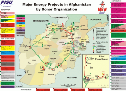
You can see one of the example maps here on the right side.
In the Afghanistan map we have drawn here the following information:
- Project financing issues - with the colour code,
- All projects in this time running with the basic information
surrounding the map,
- The status of the project - marked by the colour of the project
related bullet, and
- The existing electrical network and the planed - including
generation, transmission and distribution.
It was a useful tool for the people and our plotter was running in
high speed ....
Why not open this collection for a commercial use - we have the maps
- you have the data ...
Let´s work together ... we are partners with
fair conditions, high quality and good prices ...
|


