| |
Welcome on our Web-Site!
We like to demonstrate you the modern possibilities of
geo-referenced data display of statistical data with geographic
relations and offer you our services in the realisation mapping
jobs for your own data, generating expressive graphics with your
data. These graphics can be used in reports, for publicity issues
and for all type of publications. Maps and plans are today part of our daily life. May of
us have a daily contact with such data, or we are
generating geo-referenced data. Tables and pages of text
surely are instructive, but a good designed graphic says
more as you can write in any pages.
|
Page content
|
External Link:
Jeffrey Sachs - A New Foreign
Policy for Europe
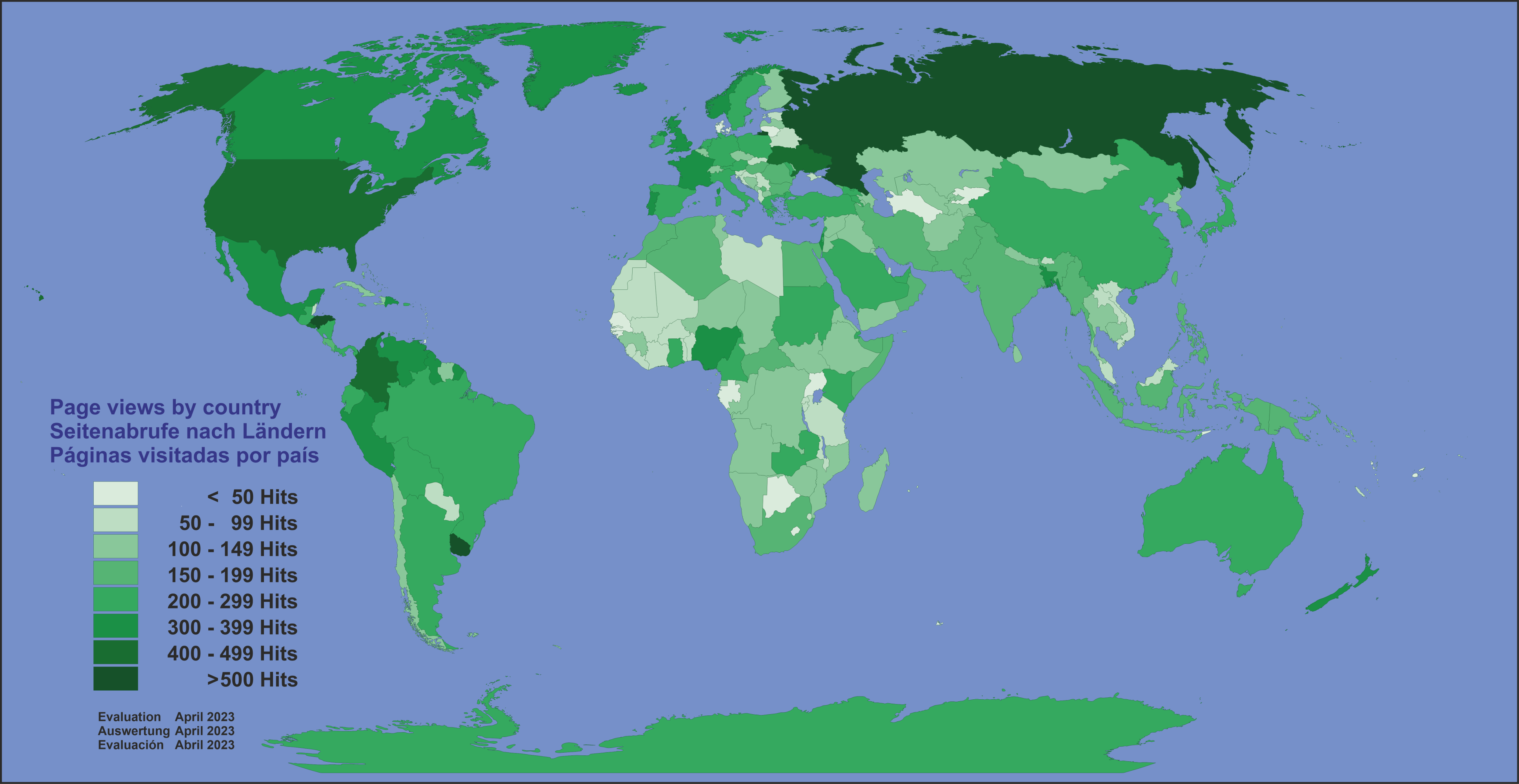
Top 10 of our site in January 2026
We were concerned with the question of what is of
interest to our visitors - we have analyzed the access logs for the
month of January 2026 more deeply than we normally do. Here you can see
the results, some of which were surprising to us:
If we summarise the results of the 3 language variants
and the display for mobile devices, the following country data
and treaties are predominantly accessed:
- Greenland and
EEUU as the most
accessed pages,
- The international treaties are clearly dominated by data on
BRICS, but lower as in the last
months.
clearly dominate with extremely high
values.
 The graphic on the left shows the frequency of calling up the countries in a grouped form. The frequency seems to vary between developing and traditional holiday countries.
The access between the language versions, with the language versions English, Spanish and German, and the version optimised for mobile devices is also roughly equal. The graphic on the left shows the frequency of calling up the countries in a grouped form. The frequency seems to vary between developing and traditional holiday countries.
The access between the language versions, with the language versions English, Spanish and German, and the version optimised for mobile devices is also roughly equal.
The language versionsare optimised for PC - dominating with 71%. This could either be due to our own rather poor design of the version for mobile devices, or that the site is visited more by professionally interested people.
Our brain is
able to capture this geo-data in an easier and faster
manner as with texts or tables, the visual impression will
be more effective penetrate our ideas. More easily as
abstract tables or texts.
Update Status country information
 In
our data collection we have currently (02/01/2026) over 290
states, dependent and self-declared independent states and
territories, former colonies and special autonomous areas within
internationally recognised states. In
our data collection we have currently (02/01/2026) over 290
states, dependent and self-declared independent states and
territories, former colonies and special autonomous areas within
internationally recognised states.
This starts with the Republic of Abkhazia - former part of the
Republic of Georgia till 1994, which understands itself as an
independent state, but is recognised internationally by only a few
states, through the Macao Special Administrative Region, which
exists since 1999 and emerged from the former Portuguese colony, or
Cyprus, listing all territorially different entities existing on
the island. In this case, these are the Republic of Cyprus, the
Turkish-occupied part - the Turkish Republic of Northern Cyprus,
but also the British colonial military bases Akrotiri and Dhekelia,
which became autonomous British territories in the decolonisation
process, as condition of the former motherland UK.
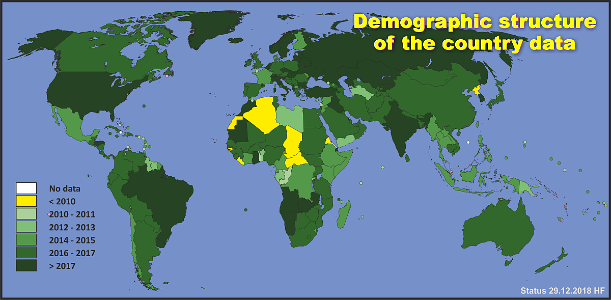
It is quite easy to get country data, these are reported with
varying topicality by many institutions, it is more difficult to
find data in the administrative structure of the respective states,
as these are usually fully expelled only in an census, but
depending on the country, this census activities are carried out in
different periods. Corresponding problem cases are shown in the
graphic above, also the age of the data for the corresponding
countries.
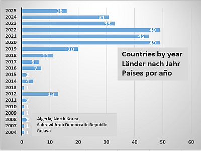
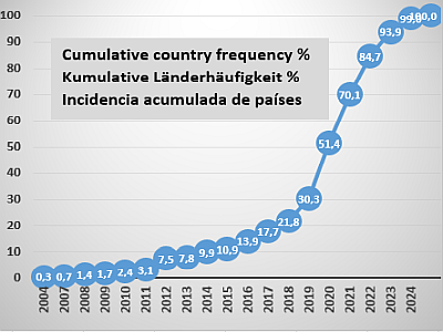 The
second graph on the left shows the age of the national data as a
cumulative percentage. This shows that about 80% of our data is
from 2016 and more recent, but also that about 2% of the country's
data is from 2010 and before. This 80% is relatively good result,
but these 2% are rather bad. The states and territories that
burden our balance sheet particularly due to the lack of recent
data are named in the first chart. The
second graph on the left shows the age of the national data as a
cumulative percentage. This shows that about 80% of our data is
from 2016 and more recent, but also that about 2% of the country's
data is from 2010 and before. This 80% is relatively good result,
but these 2% are rather bad. The states and territories that
burden our balance sheet particularly due to the lack of recent
data are named in the first chart.
If you have knowledge of sources that allow us to update the data
of these countries and territories, we would be pleased to assist
you if you could make them available to us.
We are also grateful to you for any indication of errors in maps,
data and other content.
Ukraine war, Israel wars and Trump - new
problems and hopes
The world is collapsing and always changing.
Most visibly through the new man in the White House - Donald Trump. With
his own seemingly erratic political style, he is bringing movement into
politics - for the better, one hopes - in Ukraine, with the pressure for
a ceasefire and subsequent peace - or not? We will see.
In the Russian-Ukrainian war, the Russian side
has prevailed for over a year, in the east it is going in small steps,
village by village, town by town, slowly but surely towards the west,
Ukraine is steadily losing territory. And this is fortified territory,
with extended Ukrainian positions, after which there is only flat land
as far as the Dnieper. Ukraine is also in retreat in the Kursk region,
the Russians have retaken Sudzha and are threatening to encircle the
troops operating there, as well as two other important locations
(Pokrovsk, Toretsk) in the Donetsk region. It is clear that Putin is
taking his time with the ceasefire - he does not want to give Ukraine a
month to reinforce its positions. It was also far from helpful that Mrs
Merkel felt obliged to portray the Minsk agreements as a trap for
Russia. This has unnecessarily increased Russian mistrust of the West.
 As
developments on the Russian-Ukrainian contact line are now only taking
place in small-scale actions, we have stopped providing maps of the
front line for the time being. Instead, we refer you to
https://www.understandingwar.org/ - the ‘Assessment of the Russian
offensive’ section there is updated daily, including detailed maps. As
developments on the Russian-Ukrainian contact line are now only taking
place in small-scale actions, we have stopped providing maps of the
front line for the time being. Instead, we refer you to
https://www.understandingwar.org/ - the ‘Assessment of the Russian
offensive’ section there is updated daily, including detailed maps.
See also our section
Ukraine War
The situation is different in the Middle East,
where the situation has deteriorated. Trump's ideas of resettling the
Palestinians from the Gaza Strip are not exactly what they expected and
intended, and Trump's almost unlimited support for the Netanyahu
government gives rise to fears of the worst.
The sharp rise in interest in Greenland is also
due in no small part to Trump.
There history demands answers!
Evaluation example - Terrorism Middle East
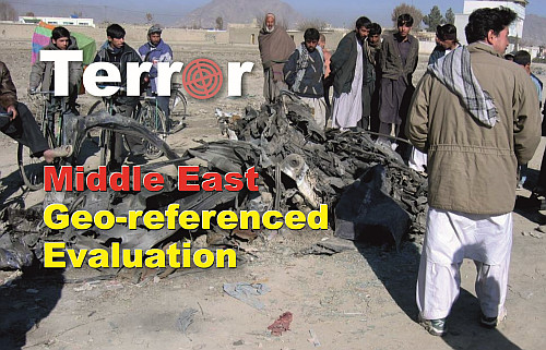
Remains of a car after a suicide attack in Kabul, Darulaman
Road, opposite the Ministry of Energy and Water,
19.12.2004 We had to re-glaze our windows ...
|
Fast selection
New International Organisation
- I
Board of Peace
Ukraine-War
Special offer
Indonesia map
What is new?
Updated countries
History in maps
Thematic maps that show a historical development
|
|