| |
Country map - Administrative structure - Population density of Burkina Faso
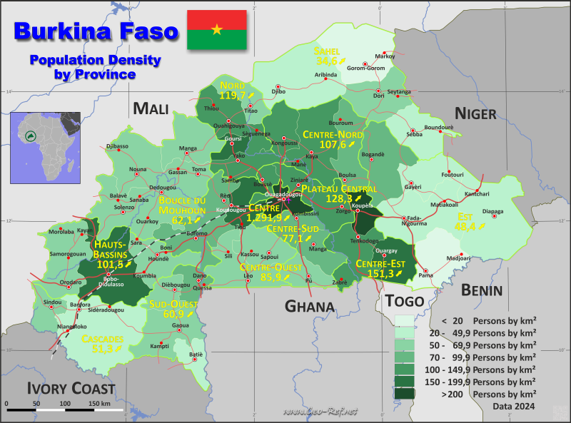
Burkina Faso - Click on the map to get a enlarged image in PDF format!
Other language versions are easy to generate, the description is in an own layer
Conditions for thematic maps with your own data and logotype
Delivery as printable file by e-mail or plot by post office |
|---|
| Layer | |
| Province: | yes |
| Streets: | yes |
| Infrastructure: | yes |
| Rivers: | yes |
|
| Size | bis A2 |
| Supply in | 7 working days |
| Price |
| 1 bis 3 | 85 € |
| > 3 | On request |
|
 |
All information published herein is free usable quoting the source,
including the maps, if they are not modified |
|---|
Statistical Data - Population density according to the administrative structure
The population data in the table below is a estimation for 2024.
Click on the column header brings the table in order of the column header. The default order is the Province name.
| Province |
ISO
3166-2 |
Region |
Capital |
Area
(km²) |
Population |
Density
(pers/km²) |
|---|
| Total |
|
|
|
272 671 |
23 409 015 |
85,9 |
|---|
| Last update: 29/05/2025 - 16:27:00 |
| Balé |
BF-BAL |
Boucle du Mouhoun |
Boromo |
4 543 |
334 571 |
73,7 |
| Bam |
BF-BAM |
Centre-Nord |
Kongoussi |
4 011 |
547 043 |
136,4 |
| Banwa |
BF-BAN |
Boucle du Mouhoun |
Solenzo |
5 804 |
387 013 |
66,7 |
| Bazèga |
BF-BAZ |
Centre-Sud |
Kombissiri |
3 947 |
306 699 |
77,7 |
| Bougouriba |
BF-BGR |
Sud-Ouest |
Diébougou |
2 777 |
174 914 |
63,0 |
| Boulgou |
BF-BLG |
Centre-Est |
Tenkodogo |
6 513 |
830 879 |
127,6 |
| Boulkiemdé |
BF-BLK |
Centre-Ouest |
Koudougou |
4 277 |
768 796 |
179,7 |
| Comoé |
BF-COM |
Cascades |
Banfora |
15 407 |
741 521 |
48,1 |
| Ganzourgou |
BF-GAN |
Plateau Central |
Zorgho |
4 166 |
545 393 |
130,9 |
| Gnagna |
BF-GNA |
Est |
Bogandé |
8 527 |
775 945 |
91,0 |
| Gourma |
BF-GOU |
Est |
Fada N’Gourma |
11 176 |
497 745 |
44,5 |
| Houet |
BF-HOU |
Hauts-Bassins |
Bobo-Dioulasso |
11 553 |
1 739 914 |
150,6 |
| Ioba |
BF-IOB |
Sud-Ouest |
Dano |
3 263 |
296 756 |
90,9 |
| Kadiogo |
BF-KAD |
Centre |
Ouagadougou |
2 770 |
3 623 784 |
1 308,2 |
| Kénédougou |
BF-KEN |
Hauts-Bassins |
Orodara |
8 401 |
456 454 |
54,3 |
| Komondjari |
BF-KMD |
Est |
Gayeri |
5 110 |
121 130 |
23,7 |
| Kompienga |
BF-KMP |
Est |
Pama |
6 942 |
139 394 |
20,1 |
| Kossi |
BF-KOS |
Boucle du Mouhoun |
Nouna |
7 430 |
396 508 |
53,4 |
| Koulpélogo |
BF-KOP |
Centre-Est |
Ouargaye |
5 380 |
411 999 |
76,6 |
| Kouritenga |
BF-KOT |
Centre-Est |
Koupéla |
2 795 |
544 323 |
194,8 |
| Kourwéogo |
BF-KOW |
Plateau Central |
Boussé |
1 596 |
200 906 |
125,9 |
| Léraba |
BF-LER |
Cascades |
Sindou |
3 017 |
203 429 |
67,4 |
| Loroum |
BF-LOR |
Nord |
Titao |
3 688 |
223 119 |
60,5 |
| Mouhoun |
BF-MOU |
Boucle du Mouhoun |
Dédougou |
6 878 |
438 025 |
63,7 |
| Nahouri |
BF-NAO |
Centre-Sud |
Pô |
3 841 |
218 839 |
57,0 |
| Namentenga |
BF-NAM |
Centre-Nord |
Boulsa |
6 384 |
585 255 |
91,7 |
| Nayala |
BF-NAY |
Boucle du Mouhoun |
Toma |
3 721 |
248 934 |
66,9 |
| Noumbiel |
BF-NOU |
Sud-Ouest |
Batié |
2 813 |
112 255 |
39,9 |
| Oubritenga |
BF-OUB |
Plateau Central |
Ziniaré |
2 841 |
350 184 |
123,3 |
| Oudalan |
BF-OUD |
Sahel |
Gorom-Gorom |
10 058 |
171 733 |
17,1 |
| Passoré |
BF-PAS |
Nord |
Yako |
3 981 |
512 043 |
128,6 |
| Poni |
BF-PON |
Sud-Ouest |
Gaoua |
7 478 |
402 775 |
53,9 |
| Sanguié |
BF-SNG |
Centre-Ouest |
Réo |
5 111 |
434 841 |
85,1 |
| Sanmatenga |
BF-SMT |
Centre-Nord |
Kaya |
9 273 |
1 002 054 |
108,1 |
| Séno |
BF-SEN |
Sahel |
Dori |
6 984 |
459 894 |
65,9 |
| Sissili |
BF-SIS |
Centre-Ouest |
Léo |
7 084 |
386 655 |
54,6 |
| Soum |
BF-SOM |
Sahel |
Djibo |
12 539 |
401 970 |
32,1 |
| Sourou |
BF-SOR |
Boucle du Mouhoun |
Tougan |
5 980 |
315 575 |
52,8 |
| Tapoa |
BF-TAP |
Est |
Diapaga |
14 758 |
706 029 |
47,8 |
| Tuy |
BF-TUI |
Hauts-Bassins |
Houndé |
5 625 |
376 198 |
66,9 |
| Yagha |
BF-YAG |
Sahel |
Sebba |
6 517 |
190 098 |
29,2 |
| Yatenga |
BF-YAT |
Nord |
Ouahigouya |
6 775 |
932 556 |
137,7 |
| Ziro |
BF-ZIR |
Centre-Ouest |
Sapouy |
5 293 |
275 959 |
52,1 |
| Zondoma |
BF-ZON |
Nord |
Gourcy |
1 982 |
271 601 |
137,1 |
| Zoundwéogo |
BF-ZOU |
Centre-Sud |
Manga |
3 666 |
347 307 |
94,7 |
The table illustrates the community values of the provinces, the same are used in the map above. The community data is Census data 2019, meanwhile the province data based on estimations 2024.
| Community |
Own |
Province |
Capital |
Area
(km²) |
Population |
Density
(pers/km²) |
|---|
| Total |
|
|
|
272 671,2 |
20 505 155,0 |
75,2 |
|---|
| Last update: 29/05/2025 - 16:27:00 |
| Absouya |
OUB-01 |
Oubritenga |
Absouya |
304,9 |
35 237 |
115,6 |
| Andemtenga |
KOT-01 |
Kouritenga |
Andemtenga |
700,0 |
69 428 |
99,2 |
| Arbinda |
SOM-01 |
Soum |
Arbinda |
2 534,0 |
98 447 |
38,9 |
| Arbollé |
PAS-01 |
Passoré |
Arbollé |
642,4 |
60 270 |
93,8 |
| Bagaré |
PAS-02 |
Passoré |
Bagaré |
463,9 |
33 334 |
71,9 |
| Bagassi |
BAL-01 |
Balé |
Bagassi |
638,3 |
42 424 |
66,5 |
| Bagré |
BLG-01 |
Boulgou |
Bagré |
568,8 |
37 855 |
66,6 |
| Bakata |
ZIR-01 |
Ziro |
Bakata |
623,0 |
32 480 |
52,1 |
| Balavé |
BAN-01 |
Banwa |
Balavé |
543,6 |
24 103 |
44,3 |
| Bama |
HOU-01 |
Houet |
Bama |
1 308,0 |
85 834 |
65,6 |
| Bana |
BAL-02 |
Balé |
Bana |
151,3 |
19 787 |
130,8 |
| Bané |
BLG-02 |
Boulgou |
Bané |
451,0 |
34 507 |
76,5 |
| Banfora |
COM-01 |
Comoé |
Banfora |
935,3 |
160 302 |
171,4 |
| Banh |
LOR-01 |
Loroum |
Banh |
1 099,0 |
38 521 |
35,1 |
| Bani |
SEN-01 |
Séno |
Bani |
1 608,0 |
88 913 |
55,3 |
| Banzon |
KEN-01 |
Kénédougou |
Banzon |
113,4 |
20 054 |
176,8 |
| Baraboulé |
SOM-02 |
Soum |
Baraboulé |
893,9 |
26 465 |
29,6 |
| Barani |
KOS-01 |
Kossi |
Barani |
1 923,0 |
54 748 |
28,5 |
| Barga |
YAT-01 |
Yatenga |
Barga |
202,4 |
51 248 |
253,2 |
| Barsalogho |
SMT-01 |
Sanmatenga |
Barsalogho |
1 804,0 |
98 553 |
54,6 |
| Bartiébougou |
KMD-01 |
Komondjari |
Bartiébougou |
899,5 |
16 934 |
18,8 |
| Baskouré |
KOT-02 |
Kouritenga |
Baskouré |
70,8 |
15 889 |
224,4 |
| Bassi |
ZON-01 |
Zondoma |
Bassi |
195,9 |
34 424 |
175,7 |
| Batié |
NOU-01 |
Noumbiel |
Batié |
1 289,0 |
44 526 |
34,5 |
| Béguédo |
BLG-03 |
Boulgou |
Béguédo |
34,1 |
28 094 |
823,9 |
| Bekuy |
TUI-01 |
Tuy |
Bekuy |
581,8 |
19 216 |
33,0 |
| Béré |
ZOU-01 |
Zoundwéogo |
Béré |
278,1 |
33 489 |
120,4 |
| Béréba |
TUI-02 |
Tuy |
Béréba |
588,0 |
31 264 |
53,2 |
| Bérégadougou |
COM-02 |
Comoé |
Bérégadougou |
286,5 |
15 164 |
52,9 |
| Biéha |
SIS-01 |
Sissili |
Biéha |
1 748,0 |
52 733 |
30,2 |
| Bilanga |
GNA-01 |
Gnagna |
Bilanga |
2 117,0 |
139 905 |
66,1 |
| Bindé |
ZOU-02 |
Zoundwéogo |
Bindé |
503,8 |
42 789 |
84,9 |
| Bingo |
BLK-01 |
Boulkiemdé |
Bingo |
250,4 |
17 154 |
68,5 |
| Bissiga |
BLG-04 |
Boulgou |
Bissiga |
267,1 |
26 183 |
98,0 |
| Bittou |
BLG-05 |
Boulgou |
Bittou |
1 345,0 |
102 394 |
76,1 |
| Boala |
NAM-01 |
Namentenga |
Boala |
385,3 |
38 224 |
99,2 |
| Bobo-Dioulasso |
HOU-02 |
Houet |
Bobo-Dioulasso |
1 806,0 |
984 603 |
545,2 |
| Bogandé |
GNA-02 |
Gnagna |
Bogandé |
1 512,0 |
128 943 |
85,3 |
| Bokin |
PAS-03 |
Passoré |
Bokin |
796,8 |
81 194 |
101,9 |
| Bomborokuy |
KOS-02 |
Kossi |
Bomborokuy |
442,3 |
19 904 |
45,0 |
| Bondigui |
BGR-01 |
Bougouriba |
Bondigui |
765,0 |
29 523 |
38,6 |
| Bondokuy |
MOU-01 |
Mouhoun |
Bondokuy |
1 074,0 |
62 214 |
57,9 |
| Boni |
TUI-03 |
Tuy |
Boni |
378,4 |
24 447 |
64,6 |
| Boromo |
BAL-03 |
Balé |
Boromo |
962,3 |
40 229 |
41,8 |
| Botou |
TAP-01 |
Tapoa |
Botou |
1 787,0 |
81 141 |
45,4 |
| Boudry |
GAN-01 |
Ganzourgou |
Boudry |
1 065,0 |
123 131 |
115,6 |
| Bougnounou |
ZIR-02 |
Ziro |
Bougnounou |
511,0 |
28 938 |
56,6 |
| Boulsa |
NAM-02 |
Namentenga |
Boulsa |
1 162,0 |
113 416 |
97,6 |
| Boundoré |
YAG-01 |
Yagha |
Boundoré |
950,5 |
15 918 |
16,7 |
| Boura |
SIS-02 |
Sissili |
Boura |
1 125,0 |
40 448 |
36,0 |
| Bourasso |
KOS-03 |
Kossi |
Bourasso |
696,3 |
20 115 |
28,9 |
| Bouroum |
NAM-03 |
Namentenga |
Bouroum |
1 290,0 |
78 149 |
60,6 |
| Bouroum-Bouroum |
PON-01 |
Poni |
Bouroum-Bouroum |
287,1 |
13 939 |
48,6 |
| Bourzanga |
BAM-01 |
Bam |
Bourzanga |
1 073,0 |
103 266 |
96,2 |
| Boussé |
KOW-01 |
Kourwéogo |
Boussé |
454,2 |
58 643 |
129,1 |
| Bousséra |
PON-02 |
Poni |
Bousséra |
427,7 |
18 133 |
42,4 |
| Boussou |
ZON-02 |
Zondoma |
Boussou |
498,9 |
32 993 |
66,1 |
| Boussoukoula |
NOU-02 |
Noumbiel |
Boussoukoula |
177,4 |
12 620 |
71,1 |
| Boussouma |
BLG-06 |
Boulgou |
Boussouma |
385,4 |
35 892 |
93,1 |
| Boussouma |
SMT-02 |
Sanmatenga |
Boussouma |
770,1 |
106 253 |
138,0 |
| Cassou |
ZIR-03 |
Ziro |
Cassou |
1 170,0 |
54 284 |
46,4 |
| Coalla |
GNA-03 |
Gnagna |
Coalla |
1 957,0 |
86 921 |
44,4 |
| Comin-Yanga |
KOP-01 |
Koulpélogo |
Comin-Yanga |
789,3 |
48 260 |
61,1 |
| Dablo |
SMT-03 |
Sanmatenga |
Dablo |
534,5 |
28 416 |
53,2 |
| Dakoro |
LER-01 |
Léraba |
Dakoro |
415,1 |
18 003 |
43,4 |
| Dalo |
ZIR-04 |
Ziro |
Dalo |
323,5 |
12 831 |
39,7 |
| Dandé |
HOU-03 |
Houet |
Dandé |
238,5 |
22 054 |
92,5 |
| Dano |
IOB-01 |
Ioba |
Dano |
651,8 |
64 237 |
98,6 |
| Dapélogo |
OUB-02 |
Oubritenga |
Dapélogo |
436,6 |
44 948 |
103,0 |
| Dargo |
NAM-04 |
Namentenga |
Dargo |
572,6 |
42 905 |
74,9 |
| Dassa |
SNG-01 |
Sanguié |
Dassa |
244,6 |
20 411 |
83,4 |
| Dédougou |
MOU-02 |
Mouhoun |
Dédougou |
1 354,0 |
123 973 |
91,6 |
| Déou |
OUD-01 |
Oudalan |
Déou |
2 215,0 |
31 431 |
14,2 |
| Di |
SOR-01 |
Sourou |
Di |
306,9 |
38 087 |
124,1 |
| Diabo |
GOU-01 |
Gourma |
Diabo |
677,1 |
57 463 |
84,9 |
| Dialgaye |
KOT-03 |
Kouritenga |
Dialgaye |
378,5 |
54 073 |
142,9 |
| Diapaga |
TAP-02 |
Tapoa |
Diapaga |
3 866,0 |
58 951 |
15,2 |
| Diapangou |
GOU-02 |
Gourma |
Diapangou |
463,2 |
34 087 |
73,6 |
| Didyr |
SNG-02 |
Sanguié |
Didyr |
631,5 |
53 361 |
84,5 |
| Diébougou |
BGR-02 |
Bougouriba |
Diébougou |
566,8 |
63 304 |
111,7 |
| Diguel |
SOM-03 |
Soum |
Diguel |
561,5 |
7 372 |
13,1 |
| Dissin |
IOB-02 |
Ioba |
Dissin |
389,8 |
45 578 |
116,9 |
| Djibasso |
KOS-04 |
Kossi |
Djibasso |
856,5 |
63 283 |
73,9 |
| Djibo |
SOM-04 |
Soum |
Djibo |
1 020,0 |
83 211 |
81,6 |
| Djigoué |
PON-03 |
Poni |
Djigoué |
776,1 |
39 238 |
50,6 |
| Djigouéra |
KEN-02 |
Kénédougou |
Djigouéra |
468,6 |
22 766 |
48,6 |
| Dokuy |
KOS-05 |
Kossi |
Dokuy |
766,1 |
40 588 |
53,0 |
| Dolo |
BGR-03 |
Bougouriba |
Dolo |
206,6 |
10 794 |
52,2 |
| Dori |
SEN-02 |
Séno |
Dori |
2 486,0 |
180 559 |
72,6 |
| Doulougou |
BAZ-01 |
Bazèga |
Doulougou |
542,7 |
30 155 |
55,6 |
| Doumbala |
KOS-06 |
Kossi |
Doumbala |
482,1 |
33 326 |
69,1 |
| Douna |
LER-02 |
Léraba |
Douna |
174,0 |
14 195 |
81,6 |
| Douroula |
MOU-03 |
Mouhoun |
Douroula |
476,4 |
18 418 |
38,7 |
| Dourtenga |
KOP-02 |
Koulpélogo |
Dourtenga |
102,1 |
13 770 |
134,9 |
| Fada N'Gourma |
GOU-03 |
Gourma |
Fada N'Gourma |
3 429,0 |
187 692 |
54,7 |
| Falagountou |
SEN-03 |
Séno |
Falagountou |
557,3 |
33 890 |
60,8 |
| Fara |
BAL-04 |
Balé |
Fara |
727,6 |
61 001 |
83,8 |
| Faramana |
HOU-04 |
Houet |
Faramana |
222,3 |
17 997 |
81,0 |
| Fô |
HOU-05 |
Houet |
Fô |
401,6 |
22 471 |
56,0 |
| Founzan |
TUI-04 |
Tuy |
Founzan |
798,5 |
43 725 |
54,8 |
| Foutouri |
KMD-02 |
Komondjari |
Foutouri |
1 316,0 |
12 452 |
9,5 |
| Gao |
ZIR-05 |
Ziro |
Gao |
577,6 |
26 453 |
45,8 |
| Gaongo |
BAZ-02 |
Bazèga |
Gaongo |
624,9 |
35 765 |
57,2 |
| Gaoua |
PON-04 |
Poni |
Gaoua |
780,1 |
78 081 |
100,1 |
| Garango |
BLG-07 |
Boulgou |
Garango |
445,0 |
91 188 |
204,9 |
| Gassan |
NAY-01 |
Nayala |
Gassan |
1 030,0 |
44 139 |
42,9 |
| Gayéri |
KMD-03 |
Komondjari |
Gayéri |
2 894,0 |
76 218 |
26,3 |
| Gbomblora |
PON-05 |
Poni |
Gbomblora |
674,4 |
25 169 |
37,3 |
| Godyr |
SNG-03 |
Sanguié |
Godyr |
247,2 |
23 824 |
96,4 |
| Gogo |
ZOU-03 |
Zoundwéogo |
Gogo |
993,0 |
49 619 |
50,0 |
| Gomboro |
SOR-02 |
Sourou |
Gomboro |
483,0 |
12 656 |
26,2 |
| Gomboussougou |
ZOU-04 |
Zoundwéogo |
Gomboussougou |
781,6 |
70 710 |
90,5 |
| Gomponsom |
PAS-04 |
Passoré |
Gomponsom |
229,8 |
27 074 |
117,8 |
| Gorgadji |
SEN-04 |
Séno |
Gorgadji |
933,1 |
34 005 |
36,4 |
| Gorom-Gorom |
OUD-02 |
Oudalan |
Gorom-Gorom |
3 305,0 |
72 454 |
21,9 |
| Gossina |
NAY-02 |
Nayala |
Gossina |
416,0 |
26 241 |
63,1 |
| Gounghin |
KOT-04 |
Kouritenga |
Gounghin |
417,5 |
46 379 |
111,1 |
| Gourcy |
ZON-03 |
Zondoma |
Gourcy |
772,8 |
117 761 |
152,4 |
| Guéguéré |
IOB-03 |
Ioba |
Guéguéré |
640,1 |
46 988 |
73,4 |
| Guiaro |
NAO-01 |
Nahouri |
Guiaro |
1 553,0 |
29 231 |
18,8 |
| Guiba |
ZOU-05 |
Zoundwéogo |
Guiba |
276,2 |
31 872 |
115,4 |
| Guibaré |
BAM-02 |
Bam |
Guibaré |
257,8 |
37 431 |
145,2 |
| Houndé |
TUI-05 |
Tuy |
Houndé |
1 245,0 |
133 403 |
107,2 |
| Imasgo |
BLK-02 |
Boulkiemdé |
Imasgo |
215,4 |
27 762 |
128,9 |
| Iolonioro |
BGR-04 |
Bougouriba |
Iolonioro |
680,5 |
35 351 |
51,9 |
| Ipelcé |
BAZ-03 |
Bazèga |
Ipelcé |
182,4 |
13 857 |
76,0 |
| Kaïn |
YAT-02 |
Yatenga |
Kaïn |
780,2 |
11 778 |
15,1 |
| Kalsaka |
YAT-03 |
Yatenga |
Kalsaka |
585,3 |
78 184 |
133,6 |
| Kampti |
PON-06 |
Poni |
Kampti |
1 299,0 |
65 725 |
50,6 |
| Kando |
KOT-05 |
Kouritenga |
Kando |
332,1 |
38 882 |
117,1 |
| Kangala |
KEN-03 |
Kénédougou |
Kangala |
502,3 |
33 064 |
65,8 |
| Kankalaba |
LER-03 |
Léraba |
Kankalaba |
313,4 |
12 592 |
40,2 |
| Kantchari |
TAP-03 |
Tapoa |
Kantchari |
3 605,0 |
109 487 |
30,4 |
| Karangasso-Sambla |
HOU-06 |
Houet |
Karangasso-Sambla |
720,4 |
29 898 |
41,5 |
| Karangasso-Vigué |
HOU-07 |
Houet |
Karangasso-Vigué |
1 966,0 |
118 402 |
60,2 |
| Kassoum |
SOR-03 |
Sourou |
Kassoum |
686,1 |
25 694 |
37,4 |
| Kaya |
SMT-04 |
Sanmatenga |
Kaya |
906,3 |
207 740 |
229,2 |
| Kayan |
KEN-04 |
Kénédougou |
Kayan |
617,3 |
29 425 |
47,7 |
| Kayao |
BAZ-04 |
Bazèga |
Kayao |
673,8 |
40 691 |
60,4 |
| Kelbo |
SOM-05 |
Soum |
Kelbo |
502,2 |
33 360 |
66,4 |
| Kiembara |
SOR-04 |
Sourou |
Kiembara |
740,8 |
39 289 |
53,0 |
| Kindi |
BLK-03 |
Boulkiemdé |
Kindi |
264,3 |
41 881 |
158,5 |
| Kirsi |
PAS-05 |
Passoré |
Kirsi |
219,7 |
29 816 |
135,7 |
| Kogho |
GAN-02 |
Ganzourgou |
Kogho |
159,7 |
23 435 |
146,7 |
| Kokologo |
BLK-04 |
Boulkiemdé |
Kokologo |
298,6 |
51 670 |
173,0 |
| Koloko |
KEN-05 |
Kénédougou |
Koloko |
760,7 |
28 626 |
37,6 |
| Kombissiri |
BAZ-05 |
Bazèga |
Kombissiri |
596,6 |
77 756 |
130,3 |
| Kombori |
KOS-07 |
Kossi |
Kombori |
224,4 |
15 118 |
67,4 |
| Komki-Ipala |
KAD-01 |
Kadiogo |
Komki-Ipala |
221,1 |
22 553 |
102,0 |
| Kompienga |
KMP-01 |
Kompienga |
Kompienga |
709,7 |
45 986 |
64,8 |
| Komsilga |
KAD-02 |
Kadiogo |
Komsilga |
317,5 |
137 278 |
432,4 |
| Komtoèga |
BLG-08 |
Boulgou |
Komtoèga |
200,6 |
27 144 |
135,3 |
| Kona |
MOU-04 |
Mouhoun |
Kona |
611,4 |
27 164 |
44,4 |
| Kongoussi |
BAM-03 |
Bam |
Kongoussi |
653,8 |
121 595 |
186,0 |
| Koper |
IOB-04 |
Ioba |
Koper |
422,9 |
28 651 |
67,7 |
| Kordié |
SNG-04 |
Sanguié |
Kordié |
455,0 |
26 227 |
57,6 |
| Korsimoro |
SMT-05 |
Sanmatenga |
Korsimoro |
603,4 |
64 349 |
106,6 |
| Kossouka |
YAT-04 |
Yatenga |
Kossouka |
167,4 |
26 926 |
160,8 |
| Koti |
TUI-06 |
Tuy |
Koti |
674,4 |
31 179 |
46,2 |
| Koubri |
KAD-03 |
Kadiogo |
Koubri |
637,8 |
60 817 |
95,4 |
| Koudougou |
BLK-05 |
Boulkiemdé |
Koudougou |
583,6 |
216 830 |
371,5 |
| Kougny |
NAY-03 |
Nayala |
Kougny |
333,4 |
22 323 |
67,0 |
| Kouka |
BAN-02 |
Banwa |
Kouka |
786,3 |
73 747 |
93,8 |
| Koumbia |
TUI-07 |
Tuy |
Koumbia |
1 359,0 |
46 019 |
33,9 |
| Koumbri |
YAT-05 |
Yatenga |
Koumbri |
613,0 |
61 818 |
100,8 |
| Koundougou |
HOU-08 |
Houet |
Koundougou |
393,4 |
21 226 |
54,0 |
| Koupéla |
KOT-06 |
Kouritenga |
Koupéla |
338,9 |
91 023 |
268,6 |
| Kourinion |
KEN-06 |
Kénédougou |
Kourinion |
600,1 |
17 885 |
29,8 |
| Kourouma |
KEN-07 |
Kénédougou |
Kourouma |
999,4 |
51 244 |
51,3 |
| Koutougou |
SOM-06 |
Soum |
Koutougou |
1 407,0 |
26 713 |
19,0 |
| Kpuéré |
NOU-03 |
Noumbiel |
Kpuéré |
571,5 |
7 391 |
12,9 |
| Kyon |
SNG-05 |
Sanguié |
Kyon |
190,9 |
24 484 |
128,3 |
| Lalgaye |
KOP-03 |
Koulpélogo |
Lalgaye |
664,5 |
19 436 |
29,2 |
| Lanfièra |
SOR-05 |
Sourou |
Lanfièra |
282,2 |
25 486 |
90,3 |
| Lankoué |
SOR-06 |
Sourou |
Lankoué |
292,4 |
21 910 |
74,9 |
| Lâ-Todin |
PAS-06 |
Passoré |
Lâ-Todin |
304,7 |
39 128 |
128,4 |
| Laye |
KOW-02 |
Kourwéogo |
Laye |
124,1 |
16 630 |
134,0 |
| Léba |
ZON-04 |
Zondoma |
Léba |
204,3 |
13 562 |
66,4 |
| Legmoin |
NOU-04 |
Noumbiel |
Legmoin |
194,6 |
19 031 |
97,8 |
| Léna |
HOU-09 |
Houet |
Léna |
580,4 |
25 393 |
43,8 |
| Léo |
SIS-03 |
Sissili |
Léo |
955,1 |
85 574 |
89,6 |
| Liptougou |
GNA-04 |
Gnagna |
Liptougou |
1 324,0 |
75 570 |
57,1 |
| Logobou |
TAP-04 |
Tapoa |
Logobou |
2 426,0 |
97 068 |
40,0 |
| Loropéni |
PON-07 |
Poni |
Loropéni |
2 059,0 |
61 952 |
30,1 |
| Loumana |
LER-04 |
Léraba |
Loumana |
408,4 |
33 787 |
82,7 |
| Loumbila |
OUB-03 |
Oubritenga |
Loumbila |
177,0 |
36 465 |
206,0 |
| Madjoari |
KMP-02 |
Kompienga |
Madjoari |
1 249,0 |
9 974 |
8,0 |
| Madouba |
KOS-08 |
Kossi |
Madouba |
161,7 |
10 150 |
62,8 |
| Malba |
PON-08 |
Poni |
Malba |
178,5 |
12 681 |
71,0 |
| Mané |
SMT-06 |
Sanmatenga |
Mané |
725,0 |
72 901 |
100,6 |
| Manga |
ZOU-06 |
Zoundwéogo |
Manga |
245,1 |
44 074 |
179,8 |
| Mangodara |
COM-03 |
Comoé |
Mangodara |
2 558,0 |
67 598 |
26,4 |
| Manni |
GNA-05 |
Gnagna |
Manni |
457,2 |
124 433 |
272,2 |
| Mansila |
YAG-02 |
Yagha |
Mansila |
1 426,0 |
25 065 |
17,6 |
| Markoye |
OUD-03 |
Oudalan |
Markoye |
1 498,0 |
28 486 |
19,0 |
| Matiacoali |
GOU-04 |
Gourma |
Matiacoali |
4 438,0 |
74 662 |
16,8 |
| Méguet |
GAN-03 |
Ganzourgou |
Méguet |
362,0 |
50 258 |
138,8 |
| Midebdo |
NOU-05 |
Noumbiel |
Midebdo |
580,2 |
15 347 |
26,5 |
| Mogtédo |
GAN-04 |
Ganzourgou |
Mogtédo |
668,3 |
73 244 |
109,6 |
| Morolaba |
KEN-08 |
Kénédougou |
Morolaba |
870,6 |
30 051 |
34,5 |
| Moussodougou |
COM-04 |
Comoé |
Moussodougou |
298,5 |
17 288 |
57,9 |
| Nagbingou |
NAM-05 |
Namentenga |
Nagbingou |
476,7 |
32 210 |
67,6 |
| Nagréongo |
OUB-04 |
Oubritenga |
Nagréongo |
497,2 |
35 451 |
71,3 |
| Nako |
PON-09 |
Poni |
Nako |
694,6 |
32 078 |
46,2 |
| Namissiguima |
SMT-07 |
Sanmatenga |
Namissiguima |
408,7 |
16 559 |
40,5 |
| Namissiguima |
YAT-06 |
Yatenga |
Namissiguima |
497,8 |
58 830 |
118,2 |
| Namounou |
TAP-05 |
Tapoa |
Namounou |
55,9 |
29 298 |
524,1 |
| Nandiala |
BLK-06 |
Boulkiemdé |
Nandiala |
212,4 |
31 314 |
147,4 |
| Nanoro |
BLK-07 |
Boulkiemdé |
Nanoro |
352,7 |
47 914 |
135,8 |
| Nasséré |
BAM-04 |
Bam |
Nasséré |
127,5 |
13 154 |
103,2 |
| Nassoumbou |
SOM-07 |
Soum |
Nassoumbou |
2 082,0 |
18 013 |
8,7 |
| N'dorola |
KEN-09 |
Kénédougou |
N'dorola |
827,3 |
40 134 |
48,5 |
| Nébiélianayou |
SIS-04 |
Sissili |
Nébiélianayou |
409,4 |
13 137 |
32,1 |
| Niabouri |
SIS-05 |
Sissili |
Niabouri |
523,2 |
30 371 |
58,0 |
| Niangoloko |
COM-05 |
Comoé |
Niangoloko |
2 790,0 |
76 855 |
27,5 |
| Niankorodougou |
LER-05 |
Léraba |
Niankorodougou |
649,8 |
51 601 |
79,4 |
| Niaogho |
BLG-09 |
Boulgou |
Niaogho |
286,4 |
25 547 |
89,2 |
| Niego |
IOB-05 |
Ioba |
Niego |
148,3 |
12 344 |
83,2 |
| Niou |
KOW-03 |
Kourwéogo |
Niou |
355,7 |
35 171 |
98,9 |
| Nobéré |
ZOU-07 |
Zoundwéogo |
Nobéré |
588,5 |
39 492 |
67,1 |
| Nouna |
KOS-09 |
Kossi |
Nouna |
1 488,0 |
89 742 |
60,3 |
| Orodara |
KEN-10 |
Kénédougou |
Orodara |
404,9 |
44 679 |
110,3 |
| Oronkua |
IOB-06 |
Ioba |
Oronkua |
389,2 |
30 692 |
78,9 |
| Ouagadougou |
KAD-04 |
Kadiogo |
Ouagadougou |
519,8 |
2 415 266 |
4 646,5 |
| Ouahigouya |
YAT-07 |
Yatenga |
Ouahigouya |
492,3 |
199 436 |
405,1 |
| Ouargaye |
KOP-04 |
Koulpélogo |
Ouargaye |
350,9 |
42 626 |
121,5 |
| Ouarkoye |
MOU-05 |
Mouhoun |
Ouarkoye |
1 070,0 |
44 616 |
41,7 |
| Ouéléni |
LER-06 |
Léraba |
Ouéléni |
398,2 |
17 993 |
45,2 |
| Ouessa |
IOB-07 |
Ioba |
Ouessa |
192,9 |
17 233 |
89,3 |
| Ouindigui |
LOR-02 |
Loroum |
Ouindigui |
611,6 |
32 855 |
53,7 |
| Oula |
YAT-08 |
Yatenga |
Oula |
560,2 |
62 832 |
112,2 |
| Ouo |
COM-06 |
Comoé |
Ouo |
2 712,0 |
45 170 |
16,7 |
| Ourgou-Manéga |
OUB-05 |
Oubritenga |
Ourgou-Manéga |
439,7 |
24 030 |
54,7 |
| Oursi |
OUD-04 |
Oudalan |
Oursi |
610,6 |
17 004 |
27,8 |
| Oury |
BAL-05 |
Balé |
Oury |
662,9 |
35 964 |
54,3 |
| Pâ |
BAL-06 |
Balé |
Pâ |
403,4 |
27 011 |
67,0 |
| Pabré |
KAD-05 |
Kadiogo |
Pabré |
408,4 |
40 387 |
98,9 |
| Padéma |
HOU-10 |
Houet |
Padéma |
928,0 |
61 859 |
66,7 |
| Pama |
KMP-03 |
Kompienga |
Pama |
4 983,0 |
61 722 |
12,4 |
| Partiaga |
TAP-06 |
Tapoa |
Partiaga |
1 641,0 |
101 439 |
61,8 |
| Pella |
BLK-08 |
Boulkiemdé |
Pella |
203,0 |
24 606 |
121,2 |
| Péni |
HOU-11 |
Houet |
Péni |
1 272,0 |
51 212 |
40,3 |
| Pensa |
SMT-08 |
Sanmatenga |
Pensa |
943,6 |
52 480 |
55,6 |
| Périgban |
PON-10 |
Poni |
Périgban |
301,2 |
9 922 |
32,9 |
| Pibaoré |
SMT-09 |
Sanmatenga |
Pibaoré |
427,8 |
42 531 |
99,4 |
| Piéla |
GNA-06 |
Gnagna |
Piéla |
825,4 |
79 488 |
96,3 |
| Pilimpikou |
PAS-07 |
Passoré |
Pilimpikou |
184,0 |
23 445 |
127,4 |
| Pissila |
SMT-10 |
Sanmatenga |
Pissila |
1 557,0 |
146 671 |
94,2 |
| Pô |
NAO-02 |
Nahouri |
Pô |
1 595,0 |
64 609 |
40,5 |
| Poa |
BLK-09 |
Boulkiemdé |
Poa |
233,5 |
32 097 |
137,5 |
| Pobé-Mengao |
SOM-08 |
Soum |
Pobé-Mengao |
546,3 |
18 312 |
33,5 |
| Pompoï |
BAL-07 |
Balé |
Pompoï |
229,1 |
14 067 |
61,4 |
| Pouni |
SNG-06 |
Sanguié |
Pouni |
673,0 |
57 067 |
84,8 |
| Poura |
BAL-08 |
Balé |
Poura |
113,4 |
19 056 |
168,0 |
| Pouytenga |
KOT-07 |
Kouritenga |
Pouytenga |
174,6 |
118 495 |
678,7 |
| Rambo |
YAT-09 |
Yatenga |
Rambo |
281,4 |
46 957 |
166,9 |
| Ramongo |
BLK-10 |
Boulkiemdé |
Ramongo |
166,4 |
29 524 |
177,4 |
| Réo |
SNG-07 |
Sanguié |
Réo |
432,4 |
75 866 |
175,5 |
| Rollo |
BAM-05 |
Bam |
Rollo |
565,1 |
42 191 |
74,7 |
| Rouko |
BAM-06 |
Bam |
Rouko |
125,6 |
21 025 |
167,4 |
| Saaba |
KAD-06 |
Kadiogo |
Saaba |
447,9 |
285 235 |
636,8 |
| Sabcé |
BAM-07 |
Bam |
Sabcé |
339,0 |
35 742 |
105,4 |
| Sabou |
BLK-11 |
Boulkiemdé |
Sabou |
456,1 |
61 836 |
135,6 |
| Safané |
MOU-06 |
Mouhoun |
Safané |
983,1 |
62 048 |
63,1 |
| Salogo |
GAN-05 |
Ganzourgou |
Salogo |
414,2 |
30 692 |
74,1 |
| Samba |
PAS-08 |
Passoré |
Samba |
354,2 |
46 247 |
130,6 |
| Sami |
BAN-03 |
Banwa |
Sami |
642,1 |
13 596 |
21,2 |
| Samoghohiri |
KEN-11 |
Kénédougou |
Samoghohiri |
453,3 |
10 189 |
22,5 |
| Samorogouan |
KEN-12 |
Kénédougou |
Samorogouan |
1 164,0 |
45 428 |
39,0 |
| Sampelga |
SEN-05 |
Séno |
Sampelga |
538,3 |
20 940 |
38,9 |
| Sanaba |
BAN-04 |
Banwa |
Sanaba |
921,6 |
38 037 |
41,3 |
| Sangha |
KOP-05 |
Koulpélogo |
Sangha |
447,3 |
54 647 |
122,2 |
| Saponé |
BAZ-06 |
Bazèga |
Saponé |
670,0 |
44 140 |
65,9 |
| Sapouy |
ZIR-06 |
Ziro |
Sapouy |
2 088,0 |
86 745 |
41,5 |
| Satiri |
HOU-12 |
Houet |
Satiri |
1 225,0 |
48 111 |
39,3 |
| Sebba |
YAG-03 |
Yagha |
Sebba |
1 072,0 |
34 881 |
32,5 |
| Séguénéga |
YAT-10 |
Yatenga |
Séguénéga |
669,4 |
98 637 |
147,4 |
| Seytenga |
SEN-06 |
Séno |
Seytenga |
861,2 |
46 409 |
53,9 |
| Siby |
BAL-09 |
Balé |
Siby |
274,6 |
18 559 |
67,6 |
| Sidéradougou |
COM-07 |
Comoé |
Sidéradougou |
3 873,0 |
137 743 |
35,6 |
| Siglé |
BLK-12 |
Boulkiemdé |
Siglé |
295,8 |
35 287 |
119,3 |
| Silly |
SIS-06 |
Sissili |
Silly |
1 124,0 |
50 795 |
45,2 |
| Sindo |
KEN-13 |
Kénédougou |
Sindo |
618,6 |
26 404 |
42,7 |
| Sindou |
LER-07 |
Léraba |
Sindou |
402,9 |
25 748 |
63,9 |
| Soaw |
BLK-13 |
Boulkiemdé |
Soaw |
188,1 |
22 039 |
117,2 |
| Solenzo |
BAN-05 |
Banwa |
Solenzo |
1 903,0 |
158 763 |
83,4 |
| Solhan |
YAG-04 |
Yagha |
Solhan |
1 338,0 |
35 975 |
26,9 |
| Sollé |
LOR-03 |
Loroum |
Sollé |
376,7 |
21 839 |
58,0 |
| Sono |
KOS-10 |
Kossi |
Sono |
389,5 |
10 115 |
26,0 |
| Soubakaniédougou |
COM-08 |
Comoé |
Soubakaniédougou |
868,1 |
37 500 |
43,2 |
| Soudougui |
KOP-06 |
Koulpélogo |
Soudougui |
1 954,0 |
92 179 |
47,2 |
| Sourgou |
BLK-14 |
Boulkiemdé |
Sourgou |
266,2 |
17 532 |
65,9 |
| Sourgoubila |
KOW-04 |
Kourwéogo |
Sourgoubila |
472,6 |
48 654 |
102,9 |
| Tambaga |
TAP-07 |
Tapoa |
Tambaga |
787,3 |
64 825 |
82,3 |
| Tangaye |
YAT-11 |
Yatenga |
Tangaye |
490,4 |
39 262 |
80,1 |
| Tanghin-Dassouri |
KAD-07 |
Kadiogo |
Tanghin-Dassouri |
217,5 |
68 848 |
316,5 |
| Tankougounadié |
YAG-05 |
Yagha |
Tankougounadié |
859,9 |
21 894 |
25,5 |
| Tansarga |
TAP-08 |
Tapoa |
Tansarga |
590,2 |
63 524 |
107,6 |
| Tansila |
BAN-06 |
Banwa |
Tansila |
1 007,0 |
38 743 |
38,5 |
| Tchériba |
MOU-07 |
Mouhoun |
Tchériba |
1 309,0 |
53 128 |
40,6 |
| Ténado |
SNG-08 |
Sanguié |
Ténado |
898,4 |
60 190 |
67,0 |
| Tenkodogo |
BLG-10 |
Boulgou |
Tenkodogo |
1 146,0 |
159 105 |
138,8 |
| Tensobentenga |
KOT-08 |
Kouritenga |
Tensobentenga |
267,0 |
25 887 |
97,0 |
| Thion |
GNA-07 |
Gnagna |
Thion |
334,7 |
41 216 |
123,1 |
| Thiou |
YAT-12 |
Yatenga |
Thiou |
1 197,0 |
66 589 |
55,6 |
| Thyou |
BLK-15 |
Boulkiemdé |
Thyou |
290,6 |
32 263 |
111,0 |
| Tiankoura |
BGR-05 |
Bougouriba |
Tiankoura |
557,6 |
14 681 |
26,3 |
| Tibga |
GOU-05 |
Gourma |
Tibga |
765,6 |
45 463 |
59,4 |
| Tiébélé |
NAO-03 |
Nahouri |
Tiébélé |
379,3 |
61 007 |
160,8 |
| Tiéfora |
COM-09 |
Comoé |
Tiéfora |
1 086,0 |
75 423 |
69,5 |
| Tikaré |
BAM-08 |
Bam |
Tikaré |
390,1 |
52 263 |
134,0 |
| Tin-Akoff |
OUD-05 |
Oudalan |
Tin-Akoff |
2 429,0 |
8 831 |
3,6 |
| Titabé |
YAG-06 |
Yagha |
Titabé |
870,7 |
37 861 |
43,5 |
| Titao |
LOR-04 |
Loroum |
Titao |
1 601,0 |
104 977 |
65,6 |
| Tô |
SIS-07 |
Sissili |
Tô |
1 199,0 |
64 020 |
53,4 |
| Toécé |
BAZ-07 |
Bazèga |
Toécé |
657,0 |
38 506 |
58,6 |
| Toéghin |
KOW-05 |
Kourwéogo |
Toéghin |
189,3 |
22 144 |
117,0 |
| Toéni |
SOR-07 |
Sourou |
Toéni |
1 429,0 |
32 708 |
22,9 |
| Toma |
NAY-04 |
Nayala |
Toma |
437,6 |
39 109 |
89,4 |
| Tongomayel |
SOM-09 |
Soum |
Tongomayel |
2 992,0 |
51 768 |
17,3 |
| Tougan |
SOR-08 |
Sourou |
Tougan |
1 760,0 |
89 181 |
50,7 |
| Tougo |
ZON-05 |
Zondoma |
Tougo |
309,8 |
41 278 |
133,2 |
| Tougouri |
NAM-06 |
Namentenga |
Tougouri |
1 545,0 |
116 140 |
75,2 |
| Toussiana |
HOU-13 |
Houet |
Toussiana |
491,0 |
21 578 |
43,9 |
| Wolonkoto |
LER-08 |
Léraba |
Wolonkoto |
255,1 |
5 504 |
21,6 |
| Yaba |
NAY-05 |
Nayala |
Yaba |
739,9 |
41 381 |
55,9 |
| Yaho |
BAL-10 |
Balé |
Yaho |
379,6 |
19 370 |
51,0 |
| Yako |
PAS-09 |
Passoré |
Yako |
785,1 |
117 422 |
149,6 |
| Yalgo |
NAM-07 |
Namentenga |
Yalgo |
575,1 |
55 375 |
96,3 |
| Yamba |
GOU-06 |
Gourma |
Yamba |
1 403,0 |
37 943 |
27,0 |
| Yargatenga |
KOP-07 |
Koulpélogo |
Yargatenga |
438,3 |
57 754 |
131,8 |
| Yargo |
KOT-09 |
Kouritenga |
Yargo |
115,3 |
19 965 |
173,2 |
| Yé |
NAY-06 |
Nayala |
Yé |
763,7 |
49 958 |
65,4 |
| Yondé |
KOP-08 |
Koulpélogo |
Yondé |
633,4 |
33 972 |
53,6 |
| Zabré |
BLG-11 |
Boulgou |
Zabré |
884,5 |
119 374 |
135,0 |
| Zam |
GAN-06 |
Ganzourgou |
Zam |
759,1 |
62 525 |
82,4 |
| Zambo |
IOB-08 |
Ioba |
Zambo |
428,4 |
20 233 |
47,2 |
| Zamo |
SNG-09 |
Sanguié |
Zamo |
662,1 |
22 865 |
34,5 |
| Zawara |
SNG-10 |
Sanguié |
Zawara |
675,8 |
27 322 |
40,4 |
| Zecco |
NAO-04 |
Nahouri |
Zecco |
47,5 |
13 440 |
282,9 |
| Zéguédéguin |
NAM-08 |
Namentenga |
Zéguédéguin |
376,8 |
37 377 |
99,2 |
| Ziga |
SMT-11 |
Sanmatenga |
Ziga |
592,8 |
48 366 |
81,6 |
| Zimtenga |
BAM-09 |
Bam |
Zimtenga |
479,3 |
49 387 |
103,0 |
| Ziniaré |
OUB-06 |
Oubritenga |
Ziniaré |
525,9 |
88 316 |
167,9 |
| Ziou |
NAO-05 |
Nahouri |
Ziou |
266,2 |
27 529 |
103,4 |
| Zitenga |
OUB-07 |
Oubritenga |
Zitenga |
459,6 |
50 162 |
109,1 |
| Zoaga |
BLG-12 |
Boulgou |
Zoaga |
254,8 |
13 233 |
51,9 |
| Zogoré |
YAT-13 |
Yatenga |
Zogoré |
238,0 |
23 478 |
98,6 |
| Zonsé |
BLG-13 |
Boulgou |
Zonsé |
244,2 |
37 327 |
152,9 |
| Zorgho |
GAN-07 |
Ganzourgou |
Zorgho |
394,0 |
76 431 |
194,0 |
| Zoungou |
GAN-08 |
Ganzourgou |
Zoungou |
343,9 |
43 047 |
125,2 |
Membership in international organisations and treaties
Expand list
Political Alliances
Regional Unions
Military alliances/Arms control
Law enforcement
Business Alliances
Financial
Free Trade Area, Internal Market
Technical alliances
Transport
Cientific
Humanitarian Unions
Cultural Unions
 |
If you have suggestions to include other information or you find missed links, please inform us!
Click here ... |
International Border disputes
Expand list
|
Fast selection
List of international
organisations
and treaties
Existing
thematical maps
|
