| |
| Capital |
Currency | Government system |
|---|
| Jerusalem |
Israeli New Sheqelb (ILS) |
Semi-presidential system |
| Official language | Region |
Population |
|---|
| Arabic |
Middle East |
Census 2020 - 5 101 300 |
Country map - Administrative structure - Population density of Palestine
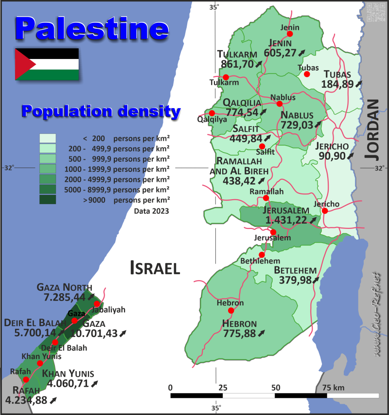
Palestine - Click on the map to get a enlarged image in PDF format!
Other language versions are easy to generate, the description is in an own layer
Conditions for thematic maps with your own data and logotype
Delivery as printable file by e-mail or plot by post office |
|---|
| Layer | |
| Province: | yes |
| Streets: | yes |
| Infrastructure: | no |
| Rivers: | yes |
|
| Size | bis A2 |
| Supply in | 7 working days |
| Price |
| 1 bis 3 | 65 € |
| > 3 | On request |
|
 |
| Observation |
Only administrative structure - without infrasructure |
All information published herein is free usable quoting the source,
including the maps, if they are not modified |
|---|
Statistical Data - Population density according to the administrative structure
The population data in the table below is the census data from 2020, last available data.
Click on the column header brings the table in order of the column header. The default order is the Governorate name.
| Governorate |
ISO
3166-2 |
Arabic |
rritory |
Capital |
Area
(km²) |
Population |
Density
(pers/km²) |
|---|
| Total |
|
|
|
|
6 001 |
5 101 300 |
850,07 |
|---|
| Last update: 01/10/2024 - 02:23:41 |
| Betlehem |
PS-BTH |
محافظة بيت لحم |
West Bank |
Betlehem |
644 |
229 900 |
356,99 |
| Deir El Balah |
PS-DEB |
محافظة دير البلح |
Gaza |
Deir El Balah |
56 |
294 300 |
5 255,36 |
| Gaza City |
PS-GZA |
محافظة غزة |
Gaza |
Gaza City |
70 |
696 000 |
9 942,86 |
| Hebron |
PS-HBN |
محافظة الخليل |
West Bank |
Hebron |
1 060 |
762 500 |
719,34 |
| Jenin |
PS-JEN |
محافظة جنين |
West Bank |
Jenin |
583 |
332 100 |
569,64 |
| Jericho |
PS-JRH |
محافظة أريحا |
West Bank |
Jericho |
608 |
52 400 |
86,18 |
| Jerusalem |
PS-JEM |
محافظة القدس |
West Bank |
Jerusalem |
344 |
461 700 |
1 342,15 |
| Khan Yunis |
PS-KYS |
محافظة خان يونس |
Gaza |
Khan Yunis |
108 |
401 600 |
3 718,52 |
| Nablus |
PS-NBS |
محافظة نابلس |
West Bank |
Nablus |
592 |
407 800 |
688,85 |
| North Gaza |
PS-NGZ |
محافظة شمال غزة |
Gaza |
Jabaliyah |
61 |
403 500 |
6 614,75 |
| Qalqilia |
PS-QQA |
محافظة قلقيلية |
West Bank |
Qalqilia |
164 |
119 000 |
725,61 |
| Rafah |
PS-RFH |
محافظة رفح |
Gaza |
Rafah |
65 |
252 700 |
3 887,69 |
| Ramallah |
PS-RBH |
محافظة رام الله والبيرة |
West Bank |
Ramallah |
844 |
347 800 |
412,09 |
| Salfit |
PS-SLT |
محافظة سلفيت |
West Bank |
Salfit |
191 |
80 200 |
419,9 |
| Tubas |
PS-TBS |
محافظة طوباس |
West Bank |
Tubas |
372 |
64 500 |
173,39 |
| Tulkarm |
PS-TKM |
محافظة طولكرم |
West Bank |
Tulkarm |
239 |
195 300 |
817,15 |
Membership in international organisations and treaties
Expand list
Political Alliances
Regional Unions
Military alliances/Arms control
Law enforcement
Business Alliances
Financial
Free Trade Area, Internal Market
Technical alliances
Transport
Cientific
Humanitarian Unions
Cultural Unions
 |
If you have suggestions to include other information or you find missed links, please inform us!
Click here ... |
International Border disputes
Expand list
|
Fast selection
List of international
organisations
and treaties
Existing
thematical maps
Poulation density for 2020 Land use West Bank - Palestinians - Jewish sattlements Elections results 25.01.2006 - last celebrated elections Zonification of the West Bank
|
