| |
| Hauptstadt |
Währung | Regierungssystem |
|---|
| Wellington |
Neuseeland-Dollar (NZD) |
Parlamentarische Demokratie |
| Amtssprache | Region |
Einwohner |
|---|
Englisch
Maori |
Australien & Ozeanien |
Schätzung 2022 - 5 123 960 |
Landkarte - Verwaltungsstruktur - Bevölkerungsdichte von Neuseeland
Neuseeland - Karte - Klicken Sie auf die Karte um eine vergößerte PDF-Datei zu öffnen
Andere Sprachversionen der Karten sind leicht und schnell zu erstellen,
die Objektnamen sind in einem Layer eingebunden
Bedingungen für die Erstellung thematischer Karten mit Ihren Daten und Logo
Lieferung als druckbare Datei per E-Mail oder als Plot per Post |
|---|
| Layer | |
| Provinz: | ja |
| Straßen: | ja |
| Infrastruktur: | ja |
| Flüße: | ja |
|
| Größe | bis A2 |
| Lieferzeit | 7 Arbeitstage |
| Preise |
| 1 bis 3 | 85 € |
| > 3 | Auf Nachfrage |
|
 |
Alle hier veröffentlichten Informationen sind frei verwendbar, wenn die Quelle zitiert wird.
Dies schliesst die Karten ein, wenn sie nicht verändert
|
|---|
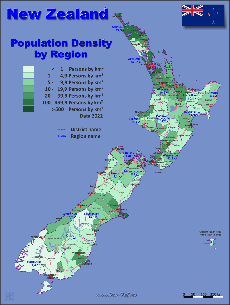
Statistische Daten - Bevölkerungsdichte nach Verwaltungsstruktur
Die Bevölkerungsdaten der nachfolgenden Tabelle sind Schätzungen das Jahr 2022, basierend auf Volkszählungwerten aus dem Jahre 2018.
Klicken Sie im Tabellenkopf neben die Spaltenbezeichnung um die Tabelle nach der gewünschten Variable zu ordnen. Voreingestellt ist die Ordnung nach die Region.
| Region |
ISO
3166-2 |
island |
Hauptstadt |
Fläche
(km²) |
Bevölkerung |
Dichte
(pers/km²) |
|---|
| Total |
|
|
|
264 974 |
5 123 960 |
19,3 |
|---|
| Aktualisiert am: 12.06.2025 - 08:44:31 |
| Auckland |
NZ-AUK |
North |
Auckland |
4 940 |
1 695 200 |
343,2 |
| Bay of Plenty |
NZ-BOP |
North |
Whakatane |
12 058 |
351 360 |
29,1 |
| Canterbury |
NZ-CAN |
South |
Christchurch |
39 058 |
649 580 |
16,6 |
| Gisborne |
NZ-GIS |
North |
Gisborne |
8 386 |
52 100 |
6,2 |
| Hawke´s Bay |
NZ-HKB |
North |
Napier |
12 741 |
182 540 |
14,3 |
| Manawatu-Wanganui |
NZ-MWT |
North |
Palmerston North |
22 071 |
258 150 |
11,7 |
| Marlborough |
NZ-MBH |
South |
Blenheim |
12 505 |
56 060 |
4,5 |
| Nelson |
NZ-NSN |
South |
Nelson |
424 |
54 500 |
128,5 |
| Northland |
NZ-NTL |
North |
Whangarei |
12 508 |
201 500 |
16,1 |
| Otago |
NZ-OTA |
South |
Dunedin |
35 405 |
248 050 |
7,0 |
| Southland |
NZ-STL |
South |
Invercargill |
31 195 |
81 550 |
2,6 |
| Taranaki |
NZ-TKI |
North |
Stratford |
7 943 |
130 450 |
16,4 |
| Tasman |
NZ-TAS |
South |
Richmond |
9 616 |
58 700 |
6,1 |
| Walkato |
NZ-WKO |
North |
Hamilton |
24 901 |
513 820 |
20,6 |
| Wellingotn |
NZ-WGN |
North |
Wellington |
7 979 |
557 650 |
69,9 |
| West Coast |
NZ-WTC |
South |
Greymouth |
23 244 |
32 750 |
1,4 |
Neben der Regionalstruktur ist Neuseeland in Distrikte unterteilt. Die folgende Tabelle stellt diese Struktur dar.
| Distrikt |
HASC |
region |
Hauptstadt |
Fläche
(km²) |
Bevölkerung |
Dichte
(pers/km²) |
|---|
| Total |
|
|
|
264 974 |
5 123 960 |
19,3 |
|---|
| Aktualisiert am: 12.06.2025 - 08:44:31 |
| Ashburton |
CA-AB |
Canterbury |
Canterbury |
6 183 |
36 300 |
5,9 |
| Auckland |
AU-AL |
Auckland |
Auckland |
4 940 |
1 695 200 |
343,2 |
| Bay of Plenty |
BP-WB |
Bay of Plenty |
Greerton |
1 951 |
59 700 |
30,6 |
| Buller |
WC-BU |
West Coast |
Westport |
7 942 |
9 730 |
1,2 |
| Carterton |
WG-CR |
Wellingotn |
Carterton |
1 180 |
10 250 |
8,7 |
| Central Hawke´s Bay |
HB-CH |
Hawke´s Bay |
Waipawa |
3 332 |
15 950 |
4,8 |
| Central Otago |
OT-CO |
Otago |
Alexandra |
9 956 |
25 500 |
2,6 |
| Chatham Islands |
CI-CT |
Canterbury |
Waitangi |
794 |
800 |
1,0 |
| Christchurch City |
CA-CC |
Canterbury |
Christchurch |
1 415 |
389 300 |
275,1 |
| Clutha |
OT-CL |
Otago |
Balclutha |
6 334 |
18 650 |
2,9 |
| Dunedin City |
OT-DU |
Otago |
Dunedin |
3 287 |
130 400 |
39,7 |
| Far North |
NO-FN |
Northland |
Kaikohe |
6 687 |
73 800 |
11,0 |
| Gisborne |
GI-GB |
Gisborne |
Gisborne |
8 386 |
52 100 |
6,2 |
| Gore |
SO-GO |
Southland |
Gore |
1 254 |
13 000 |
10,4 |
| Grey |
WC-GR |
West Coast |
Greymouth |
3 474 |
14 200 |
4,1 |
| Hamilton City |
WK-HM |
Walkato |
Hamilton |
110 |
179 900 |
1 635,5 |
| Hastings |
HB-HS |
Hawke´s Bay |
Hastings |
5 227 |
90 600 |
17,3 |
| Hauraki |
WK-HK |
Walkato |
Paeroa |
1 270 |
22 200 |
17,5 |
| Horowhenua |
MW-HW |
Manawatu-Wanganui |
Levin |
1 064 |
37 000 |
34,8 |
| Hurunui |
CA-HN |
Canterbury |
Amberley |
8 641 |
13 700 |
1,6 |
| Invercargill City |
SO-IC |
Southland |
Invercargill |
389 |
56 800 |
146,0 |
| Kaikoura |
CA-KK |
Marlborough |
Kaikoura |
2 047 |
4 160 |
2,0 |
| Kaipara |
NO-KP |
Northland |
Dargaville |
3 109 |
27 200 |
8,7 |
| Kapiti Coast |
WG-KC |
Wellingotn |
Paraparaumu |
731 |
57 600 |
78,8 |
| Kawerau |
BP-KW |
Bay of Plenty |
Kawerau |
24 |
7 760 |
323,3 |
| Lower Hutt City |
WG-LH |
Wellingotn |
Lower Hutt |
376 |
112 500 |
299,2 |
| Mackenzie |
CA-MZ |
Canterbury |
Fairlie |
7 140 |
5 460 |
0,8 |
| Manawatu |
MW-MN |
Manawatu-Wanganui |
Feilding |
2 657 |
33 900 |
12,8 |
| Marlborough |
MA-MB |
Marlborough |
Blenheim |
10 458 |
51 900 |
5,0 |
| Masterton |
WG-MT |
Wellingotn |
Masterton |
2 300 |
29 000 |
12,6 |
| Matamata-Piako |
WK-MP |
Walkato |
Te Aroha |
1 755 |
37 100 |
21,1 |
| Napier City |
HB-NR |
Hawke´s Bay |
Napier |
105 |
66 800 |
636,2 |
| Nelson City |
NE-NL |
Nelson |
Nelson |
424 |
54 500 |
128,5 |
| New Plymouth |
TK-NP |
Taranaki |
New Plymouth |
2 205 |
87 700 |
39,8 |
| Opotiki |
BP-OP |
Bay of Plenty |
Opotiki |
3 089 |
10 500 |
3,4 |
| Otorohanga |
WK-OH |
Walkato |
Otorohanga |
1 999 |
10 850 |
5,4 |
| Palmerston North City |
MW-PN |
Manawatu-Wanganui |
Palmerston North |
395 |
90 400 |
228,9 |
| Porirua City |
WG-PR |
Wellingotn |
Porirua |
175 |
61 600 |
352,0 |
| Queenstown-Lakes |
OT-QL |
Otago |
Queenstown |
8 719 |
49 500 |
5,7 |
| Rangitikei |
MW-RT |
Manawatu-Wanganui |
Marton |
4 484 |
16 100 |
3,6 |
| Rotorua |
WK-RR |
Bay of Plenty |
Rotorua |
2 409 |
76 800 |
31,9 |
| Ruapehu |
MW-RP |
Manawatu-Wanganui |
Taumarunui |
6 734 |
13 000 |
1,9 |
| Selwyn |
CA-SY |
Canterbury |
Rolleston |
6 381 |
79 300 |
12,4 |
| South Taranaki |
TK-ST |
Taranaki |
Hawera |
3 575 |
32 600 |
9,1 |
| South Waikato |
WK-SW |
Walkato |
Tokoroa |
1 819 |
29 600 |
16,3 |
| South Wairarapa |
WG-SP |
Wellingotn |
Martinborough |
2 387 |
25 900 |
10,9 |
| Southland |
SO-SL |
Southland |
Invercargill |
29 552 |
11 750 |
0,4 |
| Stratford |
TK-SF |
Taranaki |
Stratford |
2 163 |
10 150 |
4,7 |
| Tararua |
MW-TR |
Manawatu-Wanganui |
Dannevirke |
4 364 |
19 050 |
4,4 |
| Tasman |
TS-TM |
Tasman |
Richmond |
9 616 |
58 700 |
6,1 |
| Taupo |
WK-TP |
Walkato |
Taupo |
6 333 |
41 400 |
6,5 |
| Tauranga City |
BP-TG |
Bay of Plenty |
Tauranga |
135 |
158 300 |
1 172,6 |
| Thames-Coromandel |
WK-TC |
Walkato |
Thames |
2 207 |
33 700 |
15,3 |
| Timaru |
CA-TU |
Canterbury |
Timaru |
2 733 |
48 500 |
17,7 |
| Upper Hutt City |
WG-UH |
Wellingotn |
Upper Hutt |
540 |
47 700 |
88,3 |
| Waikato |
WK-WT |
Walkato |
Ngaruawahia |
4 403 |
88 900 |
20,2 |
| Waimakariri |
CA-WR |
Canterbury |
Rangiora |
2 217 |
67 900 |
30,6 |
| Waimate |
CA-WM |
Canterbury |
Waimate |
3 554 |
8 320 |
2,3 |
| Waipa |
WK-WP |
Walkato |
Te Awamutu |
1 470 |
60 500 |
41,2 |
| Wairoa |
HB-WW |
Hawke´s Bay |
Wairoa |
4 077 |
9 190 |
2,3 |
| Waitaki |
OT-WI |
Otago |
Oamaru |
7 109 |
24 000 |
3,4 |
| Waitomo |
WK-WO |
Walkato |
Te Kuiti |
3 535 |
9 670 |
2,7 |
| Wellington City |
WG-WE |
Wellingotn |
Wellington |
290 |
213 100 |
734,8 |
| Westland |
WC-WL |
West Coast |
Hokitika |
11 828 |
8 820 |
0,7 |
| Whakatane |
BP-WH |
Bay of Plenty |
Whakatane |
4 450 |
38 300 |
8,6 |
| Whanganui |
MW-WU |
Manawatu-Wanganui |
Whanganui |
2 373 |
48 700 |
20,5 |
| Whangarei |
NO-WN |
Northland |
Whangarei |
2 712 |
100 500 |
37,1 |
Mitgliedschaft in internationalen Organisationen und Verträgen
Liste ausklappen
Political Alliances
Regional Unions
Military alliances/Arms control
Law enforcement
Business Alliances
Fishery
Financial
Free Trade Area, Internal Market
Technical alliances
Environment
Transport
Cientific
Humanitarian Unions
Cultural Unions
 |
Wenn Sie Organisationen oder Verträge vermissen, oder einen Link-Fehler entdecken - Bitte informieren Sie uns!
Bitte hier klicken ... |
|
Schnellauswahl
Liste internationaler
Organisationen
und Verträge
Vorliegende
thematische Karten
|
