| |
| Hauptstadt |
Währung | Regierungssystem |
|---|
| Valletta |
Euro (EUR) |
Parlamentarische Demokratie |
| Amtssprache | Region |
Einwohner |
|---|
Maltesisch
Englisch |
Europa |
Schätzung 2024 - 563 443 |
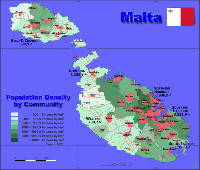
Landkarte - Verwaltungsstruktur - Bevölkerungsdichte von Malta
Malta - Karte - Klicken Sie auf die Karte um eine vergößerte PDF-Datei zu öffnen
Andere Sprachversionen der Karten sind leicht und schnell zu erstellen,
die Objektnamen sind in einem Layer eingebunden
Bedingungen für die Erstellung thematischer Karten mit Ihren Daten und Logo
Lieferung als druckbare Datei per E-Mail oder als Plot per Post |
|---|
| Layer | |
| Provinz: | ja |
| Straßen: | ja |
| Infrastruktur: | ja |
| Flüße: | ja |
|
| Größe | bis A2 |
| Lieferzeit | 7 Arbeitstage |
| Preise |
| 1 bis 3 | 80 € |
| > 3 | Auf Nachfrage |
|
 |
Alle hier veröffentlichten Informationen sind frei verwendbar, wenn die Quelle zitiert wird.
Dies schliesst die Karten ein, wenn sie nicht verändert
|
|---|
Statistische Daten - Bevölkerungsdichte nach Verwaltungsstruktur
Die Bevölkerungsdaten der nachfolgenden Tabelle sind Volkszählungwerte aus dem Jahre 2021, letzte verfügbare Daten.
Für die Regionen bestehen keine ISO-Codes, diese sind auf Distriktsebene - in der zweiten Tabelle - festgelegt. Die Regionen sind als statistische Einheiten formuliert.
Klicken Sie im Tabellenkopf neben die Spaltenbezeichnung um die Tabelle nach der gewünschten Variable zu ordnen. Voreingestellt ist die Ordnung nach die Region.
| Region |
HASC |
Island |
Hauptstadt |
Fläche
(km²) |
Bevölkerung |
Dichte
(pers/km²) |
|---|
| Total |
|
|
|
315,2 |
563 443 |
1 787,6 |
|---|
| Updated am: 02.02.2025 - 20:17:54 |
| Gozo & Comino |
MT.GO |
Gozo & Comino |
Victoria |
63,6 |
40 926 |
643,5 |
| Northern |
MT.NO |
Malta |
Mosta |
73,6 |
104 664 |
1 422,1 |
| Northern Harbour |
MT.CE |
Malta |
Qormi |
25,1 |
177 848 |
7 085,6 |
| South Eastern |
MT.SE |
Malta |
Zejtun |
54,3 |
81 869 |
1 507,7 |
| Southern Harbour |
MT.SO |
Malta |
Valletta |
26,1 |
89 462 |
3 427,7 |
| Western |
MT.WE |
Malta |
Zebbug |
72,5 |
68 674 |
947,2 |
Die Regionen unterteilen sich in Distrikte, welche in der folgenden Tabelle in ihrer Zuordung zu den Regionen dargestellt sind.
| Distrikt |
ISO 3166-2 |
Region |
Hauptstadt |
Fläche
(km²) |
Bevölkerung |
Dichte
(pers/km²) |
|---|
| Total |
|
|
|
315,2 |
563 443 |
1 787,6 |
|---|
| Updated am: 02.02.2025 - 20:17:54 |
| Attard |
MT-01 |
Western |
Attard |
6,6 |
12 952 |
1 962,4 |
| Balzan |
MT-02 |
Western |
Balzan |
0,6 |
4 977 |
8 295,0 |
| Birgu |
MT-03 |
Southern Harbour |
Birgu |
0,5 |
2 265 |
4 530,0 |
| Birkirkara |
MT-04 |
Northern Harbour |
Birkirkara |
2,7 |
28 841 |
10 681,9 |
| Birzebbuga |
MT-05 |
South Eastern |
Birzebbuga |
9,2 |
12 404 |
1 348,3 |
| Bormla |
MT-06 |
Southern Harbour |
Cospicua |
0,9 |
4 782 |
5 313,3 |
| Dingli |
MT-07 |
Western |
Dingli |
5,7 |
3 906 |
685,3 |
| Fgura |
MT-08 |
Southern Harbour |
Fgura |
1,1 |
13 861 |
12 600,9 |
| Fontana |
MT-10 |
Gozo & Comino |
Fontana |
0,5 |
1 150 |
2 300,0 |
| Furjana |
MT-09 |
Southern Harbour |
Floriana |
0,9 |
2 072 |
2 302,2 |
| Ghajnsielem |
MT-13 |
Gozo & Comino |
Ghajnsielem |
7,2 |
3 721 |
516,8 |
| Gharb |
MT-14 |
Gozo & Comino |
Gharb |
4,6 |
1 585 |
344,6 |
| Gharghur |
MT-15 |
Northern |
Gharghur |
2,0 |
3 947 |
1 973,5 |
| Ghasri |
MT-16 |
Gozo & Comino |
Ghasri |
5,0 |
519 |
103,8 |
| Ghaxaq |
MT-17 |
South Eastern |
Ghaxaq |
3,9 |
5 791 |
1 484,9 |
| Gudja |
MT-11 |
South Eastern |
Gudja |
2,3 |
3 440 |
1 495,7 |
| Gzira |
MT-12 |
Northern Harbour |
Gzira |
1,5 |
12 158 |
8 105,3 |
| Hamrun |
MT-18 |
Northern Harbour |
Hamrun |
1,1 |
11 751 |
10 682,7 |
| Iklin |
MT-19 |
Western |
Iklin |
1,7 |
3 648 |
2 145,9 |
| Imdina |
MT-29 |
Western |
Notabile |
0,9 |
199 |
221,1 |
| Imgarr |
MT-31 |
Northern |
Imgarr |
16,1 |
5 110 |
317,4 |
| Imqabba |
MT-33 |
South Eastern |
Imqabba |
2,6 |
3 653 |
1 405,0 |
| Imsida |
MT-34 |
Northern Harbour |
Imsida |
1,7 |
15 815 |
9 302,9 |
| Imtarfa |
MT-35 |
Western |
Imtarfa |
0,7 |
2 564 |
3 662,9 |
| Kalkara |
MT-21 |
Southern Harbour |
Kalkara |
1,8 |
3 224 |
1 791,1 |
| Kercem |
MT-22 |
Gozo & Comino |
Kercem |
5,5 |
1 922 |
349,5 |
| Kirkop |
MT-23 |
South Eastern |
Kirkop |
1,1 |
2 599 |
2 362,7 |
| Lija |
MT-24 |
Western |
Lija |
1,1 |
3 740 |
3 400,0 |
| Luqa |
MT-25 |
Southern Harbour |
Luqa |
6,7 |
7 335 |
1 094,8 |
| Marsa |
MT-26 |
Southern Harbour |
Marsa |
2,8 |
5 861 |
2 093,2 |
| Marsaskala |
MT-27 |
South Eastern |
Marsaskala |
5,4 |
18 253 |
3 380,2 |
| Marsaxlokk |
MT-28 |
South Eastern |
Marsaxlokk |
4,7 |
4 145 |
881,9 |
| Mellieha |
MT-30 |
Northern |
Mellieha |
22,6 |
14 004 |
619,6 |
| Mosta |
MT-32 |
Northern |
Mosta |
6,8 |
25 152 |
3 698,8 |
| Munxar |
MT-36 |
Gozo & Comino |
Munxar |
2,8 |
1 861 |
664,6 |
| Nadur |
MT-37 |
Gozo & Comino |
Nadur |
7,2 |
4 613 |
640,7 |
| Naxxar |
MT-38 |
Northern |
Naxxar |
11,6 |
17 836 |
1 537,6 |
| Paola |
MT-39 |
Southern Harbour |
Paola |
2,5 |
9 789 |
3 915,6 |
| Pembroke |
MT-40 |
Northern Harbour |
Pembroke |
2,3 |
3 725 |
1 619,6 |
| Pieta |
MT-41 |
Northern Harbour |
Pieta |
0,5 |
6 901 |
13 802,0 |
| Qala |
MT-42 |
Gozo & Comino |
Qala |
5,9 |
2 340 |
396,6 |
| Qormi |
MT-43 |
Northern Harbour |
Pinto |
5,0 |
19 567 |
3 913,4 |
| Qrendi |
MT-44 |
South Eastern |
Qrendi |
4,9 |
3 263 |
665,9 |
| Rabat |
MT-45 |
Western |
Rabat |
26,6 |
12 284 |
461,8 |
| Safi |
MT-47 |
South Eastern |
Safi |
2,3 |
2 934 |
1 275,7 |
| San Giljan |
MT-48 |
Northern Harbour |
San Giljan |
1,6 |
14 524 |
9 077,5 |
| San Gwann |
MT-49 |
Northern Harbour |
San Gwann |
2,6 |
15 697 |
6 037,3 |
| San Lawrenz |
MT-50 |
Gozo & Comino |
San Lawrenz |
3,6 |
797 |
221,4 |
| San Pawl il-Bahar |
MT-51 |
Northern |
San Pawl il-Bahar |
14,5 |
38 615 |
2 663,1 |
| Sannat |
MT-52 |
Gozo & Comino |
Sannat |
3,8 |
2 254 |
593,2 |
| Santa Lucija |
MT-53 |
Southern Harbour |
Santa Lucija |
0,7 |
2 642 |
3 774,3 |
| Santa Venera |
MT-54 |
Northern Harbour |
Santa Venera |
0,9 |
9 577 |
10 641,1 |
| Senglea (Isla) |
MT-20 |
Southern Harbour |
Senglea |
0,2 |
2 384 |
11 920,0 |
| Siggiewi |
MT-55 |
Western |
Ferdinand |
19,9 |
9 652 |
485,0 |
| Sliema |
MT-56 |
Northern Harbour |
Sliema |
1,3 |
22 037 |
16 951,5 |
| Swieqi |
MT-57 |
Northern Harbour |
Swieqi |
3,1 |
14 794 |
4 772,3 |
| Ta´Xbiex |
MT-58 |
Northern Harbour |
Ta´Xbiex |
0,8 |
2 461 |
3 076,3 |
| Tarxien |
MT-59 |
Southern Harbour |
Tarxien |
0,9 |
9 876 |
10 973,3 |
| Valletta |
MT-60 |
Southern Harbour |
Valletta |
0,8 |
5 201 |
6 501,3 |
| Victoria |
MT-46 |
Gozo & Comino |
Victoria |
2,9 |
7 477 |
2 578,3 |
| Xaghra |
MT-61 |
Gozo & Comino |
Xaghra |
2,5 |
5 337 |
2 134,8 |
| Xewkija |
MT-62 |
Gozo & Comino |
Xewkija |
4,5 |
3 675 |
816,7 |
| Xghajra |
MT-63 |
Southern Harbour |
Xghajra |
1,0 |
2 416 |
2 416,0 |
| Zabbar |
MT-64 |
Southern Harbour |
Hompesch |
5,3 |
17 754 |
3 349,8 |
| Zebbug |
MT-66 |
Western |
Rohan |
8,7 |
14 752 |
1 695,6 |
| Zebbug (Gonzo) |
MT-65 |
Gozo & Comino |
Zebbug |
7,6 |
3 675 |
483,6 |
| Zejtun |
MT-67 |
South Eastern |
Beland |
7,4 |
12 719 |
1 718,8 |
| Zurrieq |
MT-68 |
South Eastern |
Zurrieq |
10,5 |
12 668 |
1 206,5 |
Mitgliedschaft in internationalen Organisationen und Verträgen
Liste ausklappen
Political Alliances
Regional Unions
Military alliances/Arms control
Law enforcement
Business Alliances
Financial
Free Trade Area, Internal Market
Technical alliances
Transport
Cientific
Humanitarian Unions
Cultural Unions
 |
Wenn Sie Organisationen oder Verträge vermissen, oder einen Link-Fehler entdecken - Bitte informieren Sie uns!
Bitte hier klicken ... |
Internationale Grenzstreitigkeiten
Liste ausklappen
|
Schnellauswahl
Liste internationaler
Organisationen
und Verträge
Vorliegende
thematische Karten
|
