Mobil Version header


Republic of Haiti

Capital CurrencyGovernment system
Port-au-Prince Gourde (HTG) Semi-presidential system
Official languageRegion Population
Haitian Creole
French
Central America & Caribbean Estimation 2015 - 10 901 319

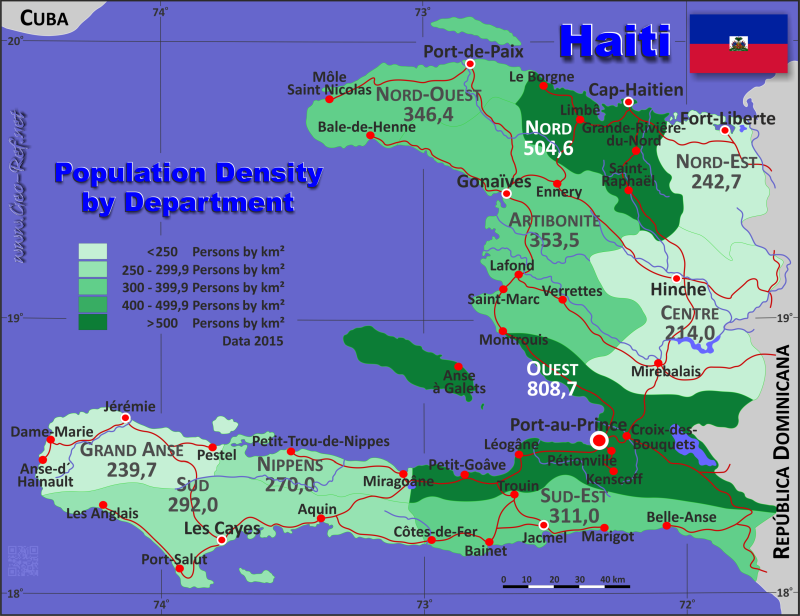
Country map - Administrative structure - Population density of Haiti

Map Haiti - Administrative division - Population density 2015

Haiti - Click on the map to get a enlarged image in PDF format!

Other language versions are easy to generate, the description is in an own layer

Conditions for thematic maps with your own data and logotype
Delivery as printable file by e-mail or plot by post office
Layer 
Province:yes
Streets:yes
Infrastructure:yes
Rivers:yes
Sizebis A2
Supply in7 working days
Price
1 bis 370 €
> 3On request
Buy
All information published herein is free usable quoting the source,
including the maps, if they are not modified

Statistical Data - Population density according to the administrative structure

The population data in the table below is a estimation for 2015.

Click on the column header brings the table in order of the column header. The default order is the Province name.

Province ISO
3166-2
Capital Area
(km²)
Population Density
(pers/km²)
Total     27 066 10 901 319 402,8
Last update: 17/01/2023 - 02:14:50
Artibonite HT-AR Gonaïves 4 887 1 727 524 353,5
Centre HT-CE Hinche 3 487 746 236 214,0
Grand'Anse HT-GA Jérémie 1 912 458 301 239,7
Nord HT-ND Cap-Haïtien 2 115 1 067 177 504,6
Nord-Est HT-NE Fort Liberté 1 623 393 967 242,7
Nord-Ouest HT-NO Port-de-Paix 2 103 728 507 346,4
Ouest HT-OU Port-au-Prince 4 983 4 029 705 808,7
Sud HT-SD Les Cayes 2 654 774 976 292,0
Sud-Est HT-SE Jacmel 2 034 632 601 311,0
Nippes HT-NI Miragoâne 1 268 342 325 270,0


Membership in international organisations and treaties

Expand list

Political Alliances

Regional Unions

Military alliances/Arms control

Law enforcement

Business Alliances

Financial

Free Trade Area, Internal Market

Technical alliances

Transport

Cientific

Humanitarian Unions

Cultural Unions


Broken Link

If you have suggestions to include other information or you find missed links, please inform us! Click here ...


International Border disputes

Expand list

Land boundaries

Maritime boundaries


See also neighboring states

Bahamas - Cuba - Dominican Republic - Guantanamo - Jamaica - Navassa - Turks & Caicos Islands


Fast selection


List of international
organisations
and treaties


Existing
thematical maps

Link-Collection

Country data

Institut Haïtien de Statistique et d’Informatique

Haiti Data

National Media

National Holydays
in German

Wikipedia

Diplomatic Relations

German Ministry
of Foreign Affairs

Spanish Foreign Ministry

OECD-iLibarary

CIA - World Factbook


International data

UN-Data

UN-Population Fund

IOM - International Organization
for Migration

World Health Organisation

UNESCO Profil

UN Children´s Fund

UNCTAD

World Bank

International
Monetary Fund

Development cooperation

USAID

EU AID


Special data

FAO - Statistics

FAO - Country Profile

UN Environment

IRENA
Alternative Energy

Meteorology and Hydrology

Human Development Index

relief
Disaster/Risk data

Gender Equality Observatory

Amnesty International

Human Rights Watch

INTERPOL Haiti

Organized Crime

Global Terrorism Database


External links change quickly - If you get a link error - Please inform us!

Broken Link Report