| |
| Capital |
Currency | Government system |
|---|
| Pretoria |
Rand (ZAR) |
Parliamentary democracy |
| Official language | Region |
Population |
|---|
Afrikaans
English
10 other local languages |
Africa |
Census 2022 - 62 027 506 |
Country map - Administrative structure - Population density of South Africa
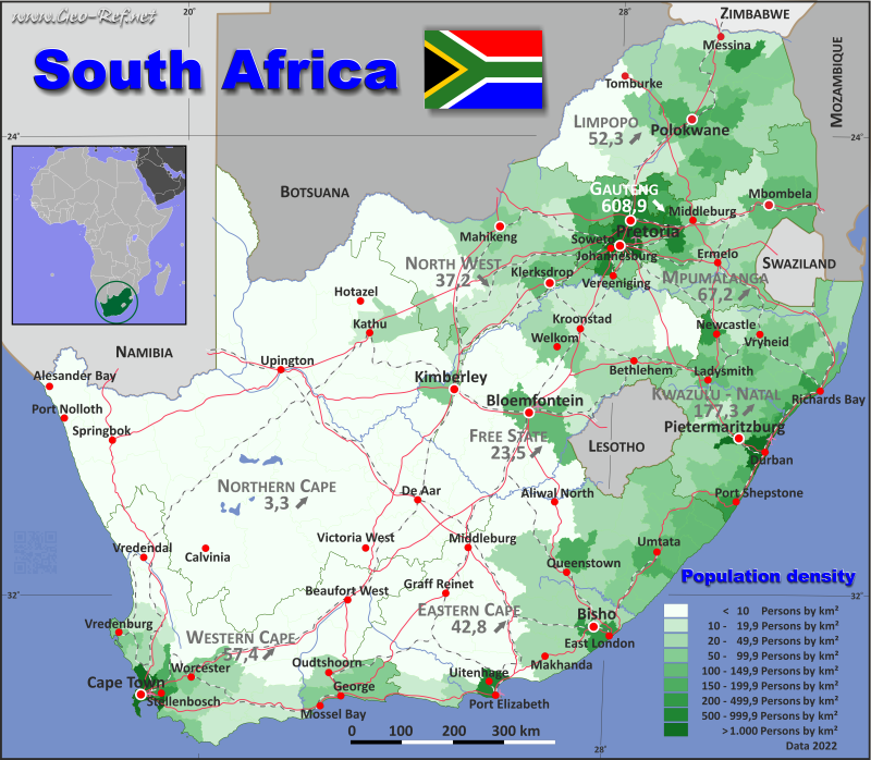
South Africa - Click on the map to get a enlarged image in PDF format!
Other language versions are easy to generate, the description is in an own layer
Conditions for thematic maps with your own data and logotype
Delivery as printable file by e-mail or plot by post office |
|---|
| Layer | |
| Province: | yes |
| Streets: | yes |
| Infrastructure: | yes |
| Rivers: | yes |
|
| Size | bis A2 |
| Supply in | 7 working days |
| Price |
| 1 bis 3 | 60 € |
| > 3 | On request |
|
 |
All information published herein is free usable quoting the source,
including the maps, if they are not modified |
|---|
Statistical Data - Population density according to the administrative structure
The population data in the table below is the census data from 2022, last available data.
Click on the column header brings the table in order of the column header. The default order is the Province name.
| Province |
ISO
3166-2 |
Capital |
Area
(km²) |
Population |
Density
(pers/km²) |
|---|
| Total |
|
|
1 220 825 |
62 027 506 |
50,8 |
|---|
| Last update: 27/05/2025 - 15:43:01 |
| Eastern Cape |
ZA-EC |
Bhisho |
168 967 |
7 230 204 |
42,8 |
| Free State |
ZA-FS |
Bloemfontein |
129 828 |
2 964 411 |
22,8 |
| Gauteng |
ZA-GP |
Johannesburg |
18 180 |
15099421 |
830,6 |
| Kwa Zulu-Natal |
ZA-ZN |
Pietermaritzburg |
94 364 |
12423908 |
131,7 |
| Limpopo |
ZA-LP |
Polokwane |
125 756 |
6 572 720 |
52,3 |
| Mpumalanga |
ZA-MP |
Nelspruit |
76 496 |
5 143 326 |
67,2 |
| North West |
ZA-NW |
Mafikeng |
104 882 |
3 804 546 |
36,3 |
| Northern Cape |
ZA-NC |
Kimberley |
372 887 |
1 355 948 |
3,6 |
| Western Cape |
ZA-WC |
Cape Town |
129 465 |
7 433 022 |
57,4 |
The provinces are divided into municipalities, the data of which are shown in the table below
| Municipality |
Own |
Province |
Capital |
Area
(km²) |
Population |
Density
(pers/km²) |
|---|
| Total |
|
|
|
1 220 825 |
62 027 506 |
50,8 |
|---|
| Last update: 27/05/2025 - 15:43:01 |
| Abaqulusi |
ZN-01 |
KwaZulu-Natal |
Vryheid |
4 314 |
247 263 |
57,3 |
| Albert Luthuli |
MP-01 |
Mpumalanga |
Carolina |
5 553 |
247 664 |
44,6 |
| Alfred Duma |
ZN-02 |
KwaZulu-Natal |
Ladysmith |
3 764 |
415 036 |
110,3 |
| Amahlathi |
EC-01 |
Eastern Cape |
Stutterheim |
4 506 |
115 703 |
25,7 |
| Ba-Phalaborwa |
LP-01 |
Limpopo |
Phalaborwa |
7 490 |
188 603 |
25,2 |
| Beaufort West |
WC-01 |
Western Cape |
Beaufort West |
21 917 |
72 972 |
3,3 |
| Bela-Bela |
LP-02 |
Limpopo |
Bela-Bela |
3 406 |
64 306 |
18,9 |
| Bergrivier |
WC-02 |
Western Cape |
Piketberg |
4 407 |
70 276 |
15,9 |
| Big Five Hlabisa |
ZN-03 |
KwaZulu-Natal |
Hluhluwe |
3 470 |
131 755 |
38,0 |
| Bitou - Plettenberg Bay |
WC-03 |
Western Cape |
Plettenberg Bay |
992 |
65 240 |
65,8 |
| Blouberg |
LP-03 |
Limpopo |
Senwabarwana |
9 540 |
192 109 |
20,1 |
| Blue Crane Route |
EC-02 |
Eastern Cape |
Somerset East |
11 068 |
49 883 |
4,5 |
| Breede Valley |
WC-04 |
Western Cape |
Worcester |
3 834 |
212 682 |
55,5 |
| Buffalo City - East London |
EC-03 |
Eastern Cape |
East London |
2 753 |
975 255 |
354,3 |
| Bushbuckridge |
MP-02 |
Mpumalanga |
Bushbuckridge |
10 248 |
750 821 |
73,3 |
| Cape Agulhas |
WC-05 |
Western Cape |
Bredasdorp |
3 470 |
40 274 |
11,6 |
| Cederberg |
WC-06 |
Western Cape |
Clanwilliam |
8 008 |
55 108 |
6,9 |
| City of Cape Town |
WC-07 |
Western Cape |
Cape Town |
2 441 |
4 772 846 |
1 955,3 |
| City of Johannesburg |
GP-01 |
Gauteng |
Johannesburg |
1 643 |
4 803 262 |
2 923,5 |
| City of Matlosana - Klerksdorp |
NW-01 |
North West |
Klerksdorp |
3 602 |
431 231 |
119,7 |
| City of Mbombela |
MP-03 |
Mpumalanga |
Mbombela |
7 152 |
818 925 |
114,5 |
| City of Tshwane - Pretoria |
GP-02 |
Gauteng |
Pretoria |
6 298 |
4 040 315 |
641,5 |
| Collins Chabane |
LP-04 |
Limpopo |
Malamulele |
5 003 |
443 798 |
88,7 |
| Dannhauser |
ZN-04 |
KwaZulu-Natal |
Dannhauser |
1 707 |
142 750 |
83,6 |
| Dawid Kruiper |
NC-01 |
Northern Cape |
Upington |
44 399 |
125 744 |
2,8 |
| Dihlabeng |
FS-01 |
Free State |
Bethlehem |
4 868 |
130 434 |
26,8 |
| Dikgatlong |
NC-02 |
Northern Cape |
Barkly West |
7 316 |
56 967 |
7,8 |
| Dipaleseng |
MP-04 |
Mpumalanga |
Balfour |
2 607 |
35 980 |
13,8 |
| Ditsobotla |
NW-02 |
North West |
Lichtenburg |
6 387 |
164 176 |
25,7 |
| Dr Beyers Naudé |
EC-04 |
Eastern Cape |
Graaff-Reinet |
28 653 |
101 001 |
3,5 |
| Dr JS Moroka |
MP-05 |
Mpumalanga |
Siyabuswa |
1 417 |
324 855 |
229,3 |
| Dr Nkosazana Dlamini Zuma |
ZN-05 |
KwaZulu-Natal |
Creighton |
3 602 |
128 565 |
35,7 |
| Drakenstein |
WC-08 |
Western Cape |
Paarl |
1 537 |
276 800 |
180,1 |
| eDumbe |
ZN-06 |
KwaZulu-Natal |
Paulpietersburg |
1 943 |
96 735 |
49,8 |
| Ekurhuleni |
GP-03 |
Gauteng |
Germiston |
1 976 |
4 066 691 |
2 058,0 |
| Elias Motsoaledi |
LP-05 |
Limpopo |
Groblersdal |
3 713 |
288 049 |
77,6 |
| Elundini |
EC-05 |
Eastern Cape |
Nqanqarhu |
5 019 |
141 762 |
28,2 |
| Emadlangeni |
ZN-07 |
KwaZulu-Natal |
Utrecht |
3 539 |
36 948 |
10,4 |
| Emakhazeni |
MP-06 |
Mpumalanga |
eMakhazeni |
4 736 |
50 165 |
10,6 |
| Emalahleni |
EC-06 |
Eastern Cape |
Lady Frere |
3 484 |
128 873 |
37,0 |
| Emalahleni |
MP-07 |
Mpumalanga |
eMalahleni |
2 678 |
434 522 |
162,3 |
| Emfuleni |
GP-04 |
Gauteng |
Vanderbijlpark |
966 |
945 650 |
978,9 |
| Emthanjeni |
NC-03 |
Northern Cape |
De Aar |
13 472 |
46 587 |
3,5 |
| Endumeni |
ZN-08 |
KwaZulu-Natal |
Dundee |
1 610 |
100 085 |
62,2 |
| Engcobo |
EC-07 |
Eastern Cape |
Ngcobo |
2 484 |
132 799 |
53,5 |
| Enoch Mgijima |
EC-08 |
Eastern Cape |
Queenstown |
13 584 |
297 055 |
21,9 |
| Ephraim Mogale |
LP-06 |
Limpopo |
Marble Hall |
2 011 |
132 468 |
65,9 |
| eThekwini - Durban |
ZN-09 |
KwaZulu-Natal |
Durban |
2 556 |
4 239 901 |
1 658,8 |
| Fetakgomo Tubatse |
LP-07 |
Limpopo |
Burgersfort |
5 693 |
575 960 |
101,2 |
| Gamagara |
NC-05 |
Northern Cape |
Kathu |
2 648 |
29 580 |
11,2 |
| Ga-Segonyana |
NC-04 |
Northern Cape |
Kuruman |
4 495 |
117 454 |
26,1 |
| George |
WC-09 |
Western Cape |
George |
5 191 |
294 929 |
56,8 |
| Govan Mbeki |
MP-08 |
Mpumalanga |
Secunda |
2 955 |
310 117 |
104,9 |
| Great Kei |
EC-09 |
Eastern Cape |
Komga |
1 700 |
35 990 |
21,2 |
| Greater Giyani |
LP-08 |
Limpopo |
Giyani |
4 167 |
316 841 |
76,0 |
| Greater Kokstad |
ZN-10 |
KwaZulu-Natal |
Kokstad |
2 680 |
81 676 |
30,5 |
| Greater Letaba |
LP-09 |
Limpopo |
Modjadjiskloof |
1 896 |
261 038 |
137,7 |
| Greater Taung |
NW-03 |
North West |
Taung |
5 637 |
202 009 |
35,8 |
| Greater Tzaneen |
LP-10 |
Limpopo |
Tzaneen |
2 896 |
478 254 |
165,1 |
| Hantam |
NC-06 |
Northern Cape |
Calvinia |
39 085 |
22 281 |
0,6 |
| Hessequa |
WC-10 |
Western Cape |
Riversdale |
5 733 |
71 918 |
12,5 |
| Impendle |
ZN-11 |
KwaZulu-Natal |
Impendle |
1 610 |
36 648 |
22,8 |
| Inkosi Langalibalele |
ZN-12 |
KwaZulu-Natal |
Estcourt |
3 399 |
230 924 |
67,9 |
| Intsika Yethu |
EC-10 |
Eastern Cape |
Cofimvaba |
2 846 |
128 101 |
45,0 |
| Inxuba Yethemba |
EC-11 |
Eastern Cape |
Cradock |
11 663 |
77 578 |
6,7 |
| JB Marks |
NW-04 |
North West |
Potchefstroom |
6 398 |
212 670 |
33,2 |
| Joe Morolong (Moshaweng) |
NC-07 |
Northern Cape |
Mothibistad |
20 180 |
125 420 |
6,2 |
| Jozini |
ZN-13 |
KwaZulu-Natal |
Jozini |
3 438 |
199 153 |
57,9 |
| Kagisano/Molopo |
NW-05 |
North West |
Ganyesa |
23 827 |
112 130 |
4,7 |
| Kai Garib |
NC-08 |
Northern Cape |
Kakamas |
26 236 |
85 104 |
3,2 |
| Kamiesberg |
NC-09 |
Northern Cape |
Garies |
14 208 |
15 130 |
1,1 |
| Kannaland |
WC-11 |
Western Cape |
Ladismith |
4 765 |
31 986 |
6,7 |
| Kareeberg |
NC-10 |
Northern Cape |
Carnarvon |
17 701 |
10 961 |
0,6 |
| Karoo Hoogland |
NC-11 |
Northern Cape |
Williston |
30 230 |
11 691 |
0,4 |
| Kgatelopele |
NC-12 |
Northern Cape |
Danielskuil |
2 478 |
19 854 |
8,0 |
| Kgetlengrivier |
NW-06 |
North West |
Koster |
3 973 |
54 759 |
13,8 |
| Khai Ma |
NC-13 |
Northern Cape |
Pofadder |
15 715 |
8 510 |
0,5 |
| Kheis |
NC-14 |
Northern Cape |
Groblershoop |
11 102 |
21 954 |
2,0 |
| King Sabata Dalindyebo |
EC-12 |
Eastern Cape |
Mthatha |
3 019 |
476 558 |
157,9 |
| Knysna |
WC-12 |
Western Cape |
Knysna |
1 109 |
96 055 |
86,6 |
| Kopanong |
FS-02 |
Free State |
Trompsburg |
15 648 |
51 832 |
3,3 |
| Kouga |
EC-14 |
Eastern Cape |
Jeffreys Bay |
3 642 |
107 014 |
29,4 |
| Kou-Kamma |
EC-13 |
Eastern Cape |
Sarah Baartman |
2 671 |
36 487 |
13,7 |
| KwaDukuza |
ZN-14 |
KwaZulu-Natal |
KwaDukuza |
740 |
324 912 |
439,1 |
| Laingsburg |
WC-13 |
Western Cape |
Laingsburg |
8 785 |
11 366 |
1,3 |
| Langeberg |
WC-14 |
Western Cape |
Ashton |
4 518 |
94 045 |
20,8 |
| Lekwa |
MP-09 |
Mpumalanga |
Standerton |
4 594 |
119 669 |
26,0 |
| Lekwa-Teemane |
NW-07 |
North West |
Christiana |
3 654 |
59 815 |
16,4 |
| Lepelle-Nkumpi |
LP-11 |
Limpopo |
Lebowakgomo |
3 484 |
284 404 |
81,6 |
| Lephalale |
LP-12 |
Limpopo |
Lephalale |
13 794 |
125 198 |
9,1 |
| Lesedi |
GP-05 |
Gauteng |
Heidelberg |
1 484 |
132 783 |
89,5 |
| Letsemeng |
FS-03 |
Free State |
Koffiefontein |
9 826 |
43 101 |
4,4 |
| Madibeng |
NW-08 |
North West |
Brits |
3 720 |
522 566 |
140,5 |
| Mafikeng |
NW-09 |
North West |
Mahikeng |
3 646 |
354 504 |
97,2 |
| Mafube |
FS-04 |
Free State |
Frankfort |
3 977 |
61 150 |
15,4 |
| Magareng |
NC-15 |
Northern Cape |
Warrenton |
1 546 |
26 816 |
17,3 |
| Makana |
EC-15 |
Eastern Cape |
Makhanda |
4 376 |
97 815 |
22,4 |
| Makhado |
LP-13 |
Limpopo |
Louis Trichardt |
7 605 |
502 452 |
66,1 |
| Makhuduthamaga |
LP-14 |
Limpopo |
Jane Furse |
2 110 |
340 328 |
161,3 |
| Maluti a Phofung |
FS-05 |
Free State |
Phuthaditjhaba |
4 338 |
398 459 |
91,9 |
| Mamusa |
NW-10 |
North West |
Schweizer-Reneke |
3 603 |
70 483 |
19,6 |
| Mandeni |
ZN-15 |
KwaZulu-Natal |
Mandeni |
555 |
180 939 |
326,0 |
| Mangaung - Bloemfontein |
FS-06 |
Free State |
Bloemfontein |
9 886 |
811 431 |
82,1 |
| Mantsopa |
FS-07 |
Free State |
Ladybrand |
4 291 |
55 897 |
13,0 |
| Maphumulo |
ZN-16 |
KwaZulu-Natal |
Maphumulo |
896 |
110 983 |
123,9 |
| Maquassi Hills |
NW-11 |
North West |
Wolmaransstad |
4 671 |
90 302 |
19,3 |
| Maruleng |
LP-15 |
Limpopo |
Hoedspruit |
3 563 |
128 137 |
36,0 |
| Masilonyana |
FS-08 |
Free State |
Theunissen |
6 618 |
63 800 |
9,6 |
| Matatiele |
EC-16 |
Eastern Cape |
Matatiele |
4 352 |
225 562 |
51,8 |
| Matjhabeng |
FS-09 |
Free State |
Welkom |
5 690 |
439 034 |
77,2 |
| Matzikama |
WC-15 |
Western Cape |
Vredendal |
12 981 |
69 043 |
5,3 |
| Mbhashe |
EC-17 |
Eastern Cape |
Dutywa |
3 303 |
240 020 |
72,7 |
| Merafong City |
GP-06 |
Gauteng |
Carletonville |
1 630 |
225 476 |
138,3 |
| Metsimaholo |
FS-10 |
Free State |
Sasolburg |
1 717 |
158 391 |
92,2 |
| Mfolozi |
ZN-17 |
KwaZulu-Natal |
KwaMbonambi |
1 300 |
159 668 |
122,8 |
| Mhlontlo |
EC-18 |
Eastern Cape |
Qumbu |
2 880 |
186 391 |
64,7 |
| Midvaal |
GP-07 |
Gauteng |
Meyerton |
1 723 |
112 254 |
65,2 |
| Mkhambathini |
ZN-18 |
KwaZulu-Natal |
Camperdown |
869 |
61 660 |
71,0 |
| Mkhondo |
MP-10 |
Mpumalanga |
Piet Retief |
4 901 |
255 411 |
52,1 |
| Mnquma |
EC-19 |
Eastern Cape |
Butterworth |
3 137 |
232 993 |
74,3 |
| Modimolle-Mookgophong |
LP-16 |
Limpopo |
Modimolle |
10 368 |
130 113 |
12,5 |
| Mogalakwena |
LP-17 |
Limpopo |
Mokopane |
6 156 |
378 198 |
61,4 |
| Mogale City |
GP-08 |
Gauteng |
Krugersdorp |
1 345 |
438 217 |
325,8 |
| Mohokare |
FS-11 |
Free State |
Zastron |
8 776 |
36 968 |
4,2 |
| Molemole |
LP-18 |
Limpopo |
Mogwadi |
3 628 |
127 130 |
35,0 |
| Moqhaka |
FS-12 |
Free State |
Kroonstad |
7 925 |
155 410 |
19,6 |
| Moretele |
NW-12 |
North West |
Makapanstad |
1 498 |
219 120 |
146,3 |
| Moses Kotane |
NW-13 |
North West |
Mogwase |
5 726 |
265 668 |
46,4 |
| Mossel Bay |
WC-16 |
Western Cape |
Mossel Bay |
2 001 |
140 075 |
70,0 |
| Mpofana |
ZN-19 |
KwaZulu-Natal |
Mooi River |
1 755 |
33 382 |
19,0 |
| Msinga |
ZN-20 |
KwaZulu-Natal |
Tugela Ferry |
2 375 |
206 001 |
86,7 |
| Msukaligwa |
MP-11 |
Mpumalanga |
Ermelo |
6 003 |
199 314 |
33,2 |
| Mthonjaneni |
ZN-21 |
KwaZulu-Natal |
Melmoth |
1 639 |
99 289 |
60,6 |
| Mtubatuba |
ZN-22 |
KwaZulu-Natal |
Mtubatuba |
1 970 |
215 869 |
109,6 |
| Musina |
LP-19 |
Limpopo |
Musina |
10 347 |
130 899 |
12,7 |
| Nala |
FS-13 |
Free State |
Bothaville |
4 129 |
90 561 |
21,9 |
| Naledi |
NW-14 |
North West |
Vryburg |
7 032 |
63 755 |
9,1 |
| Nama Khoi |
NC-16 |
Northern Cape |
Springbok |
17 990 |
67 089 |
3,7 |
| Ndlambe |
EC-20 |
Eastern Cape |
Port Alfred |
1 840 |
87 797 |
47,7 |
| Ndwedwe |
ZN-23 |
KwaZulu-Natal |
Ndwedwe |
1 079 |
165 826 |
153,7 |
| Nelson Mandela Bay - Port Elizabeth |
EC-21 |
Eastern Cape |
Gqeberha |
1 957 |
1 190 496 |
608,3 |
| Newcastle |
ZN-24 |
KwaZulu-Natal |
Newcastle |
1 856 |
507 710 |
273,6 |
| Ngqushwa |
EC-22 |
Eastern Cape |
Peddie |
2 113 |
68 300 |
32,3 |
| Ngquza Hill |
EC-23 |
Eastern Cape |
Flagstaff |
2 477 |
354 573 |
143,1 |
| Ngwathe |
FS-14 |
Free State |
Parys |
7 055 |
134 962 |
19,1 |
| Nkandla |
ZN-25 |
KwaZulu-Natal |
Nkandla |
1 828 |
108 896 |
59,6 |
| Nketoana |
FS-15 |
Free State |
Reitz |
5 605 |
66 488 |
11,9 |
| Nkomazi |
MP-12 |
Mpumalanga |
Malalane |
4 785 |
591 928 |
123,7 |
| Nongoma |
ZN-26 |
KwaZulu-Natal |
Nongoma |
2 182 |
225 278 |
103,2 |
| Nquthu |
ZN-27 |
KwaZulu-Natal |
Nquthu |
1 962 |
201 133 |
102,5 |
| Ntabankulu |
EC-24 |
Eastern Cape |
Ntabankulu |
1 385 |
146 423 |
105,7 |
| Nyandeni |
EC-25 |
Eastern Cape |
Libode |
2 474 |
304 856 |
123,2 |
| Okhahlamba |
ZN-28 |
KwaZulu-Natal |
Bergville |
3 971 |
143 132 |
36,0 |
| Oudtshoorn |
WC-17 |
Western Cape |
Oudtshoorn |
3 540 |
138 257 |
39,1 |
| Overstrand |
WC-18 |
Western Cape |
Hermanus |
1 675 |
132 495 |
79,1 |
| Phokwane |
NC-17 |
Northern Cape |
Hartswater |
828 |
80 481 |
97,2 |
| Phumelela |
FS-16 |
Free State |
Vrede |
8 197 |
52 224 |
6,4 |
| Pixley ka Seme |
MP-13 |
Mpumalanga |
Volksrust |
5 227 |
115 304 |
22,1 |
| Polokwane |
LP-20 |
Limpopo |
Polokwane |
5 054 |
843 459 |
166,9 |
| Port St Johns |
EC-26 |
Eastern Cape |
Port St Johns |
1 291 |
179 325 |
138,9 |
| Prince Albert |
WC-19 |
Western Cape |
Prince Albert |
8 153 |
17 836 |
2,2 |
| Ramotshere Moiloa |
NW-15 |
North West |
Zeerust |
7 323 |
161 605 |
22,1 |
| Rand West City - Randfontein |
GP-09 |
Gauteng |
Randfontein |
1 115 |
334 773 |
300,2 |
| Ratlou |
NW-16 |
North West |
Setlagole |
4 884 |
128 766 |
26,4 |
| Ray Nkonyeni |
ZN-29 |
KwaZulu-Natal |
Port Shepstone |
1 487 |
362 134 |
243,5 |
| Raymond Mhlaba |
EC-27 |
Eastern Cape |
Fort Beaufort |
6 357 |
178 594 |
28,1 |
| Renosterberg |
NC-18 |
Northern Cape |
Petrusville |
5 529 |
10 843 |
2,0 |
| Richmond |
ZN-30 |
KwaZulu-Natal |
Richmond |
1 231 |
62 754 |
51,0 |
| Richtersveld |
NC-19 |
Northern Cape |
Port Nolloth |
9 608 |
24 235 |
2,5 |
| Rustenburg |
NW-17 |
North West |
Rustenburg |
3 416 |
562 315 |
164,6 |
| Sakhisizwe |
EC-28 |
Eastern Cape |
Cala |
2 345 |
63 981 |
27,3 |
| Saldanha Bay |
WC-20 |
Western Cape |
Vredenburg |
2 015 |
154 635 |
76,7 |
| Senqu |
EC-29 |
Eastern Cape |
Lady Grey |
7 329 |
147 073 |
20,1 |
| Setsoto |
FS-17 |
Free State |
Ficksburg |
5 431 |
127 918 |
23,6 |
| Siyancuma |
NC-20 |
Northern Cape |
Douglas |
16 587 |
53 165 |
3,2 |
| Siyathemba |
NC-21 |
Northern Cape |
Prieska |
14 704 |
27 102 |
1,8 |
| Sol Plaatje |
NC-22 |
Northern Cape |
Kimberley |
3 312 |
270 078 |
81,5 |
| Stellenbosch |
WC-21 |
Western Cape |
Stellenbosch |
836 |
175 411 |
209,8 |
| Steve Tshwete - Middelburg |
MP-14 |
Mpumalanga |
Middelburg |
3 977 |
242 031 |
60,9 |
| Sundays River Valley |
EC-30 |
Eastern Cape |
Kirkwood |
5 995 |
53 256 |
8,9 |
| Swartland |
WC-22 |
Western Cape |
Malmesbury |
3 708 |
148 331 |
40,0 |
| Swellendam |
WC-23 |
Western Cape |
Swellendam |
3 835 |
47 114 |
12,3 |
| Thaba Chweu |
MP-15 |
Mpumalanga |
Mashishing |
5 711 |
109 223 |
19,1 |
| Thabazimbi |
LP-21 |
Limpopo |
Thabazimbi |
11 190 |
65 047 |
5,8 |
| The Msunduzi |
ZN-31 |
KwaZulu-Natal |
Pietermaritzburg |
751 |
817 725 |
1 088,8 |
| Theewaterskloof |
WC-24 |
Western Cape |
Caledon |
3 261 |
139 563 |
42,8 |
| Thembelihle |
NC-23 |
Northern Cape |
Hopetown |
8 023 |
22 542 |
2,8 |
| Thembisile |
MP-16 |
Mpumalanga |
eMpumalanga |
2 384 |
431 248 |
180,9 |
| Thulamela |
LP-22 |
Limpopo |
Thohoyandou |
2 642 |
575 929 |
218,0 |
| Tokologo |
FS-18 |
Free State |
Boshof |
9 317 |
29 455 |
3,2 |
| Tsantsabane |
NC-24 |
Northern Cape |
Postmasburg |
18 289 |
30 969 |
1,7 |
| Tswaing |
NW-18 |
North West |
Delareyville |
5 885 |
128 672 |
21,9 |
| Tswelopele |
FS-19 |
Free State |
Bultfontein |
6 534 |
56 896 |
8,7 |
| Ubuhlebezwe |
ZN-32 |
KwaZulu-Natal |
Ixopo |
1 670 |
133 032 |
79,7 |
| Ubuntu |
NC-25 |
Northern Cape |
Victoria West |
20 393 |
15 836 |
0,8 |
| Ulundi |
ZN-33 |
KwaZulu-Natal |
Ulundi |
3 251 |
221 977 |
68,3 |
| Umdoni |
ZN-34 |
KwaZulu-Natal |
Scottburgh |
990 |
156 443 |
158,0 |
| Umhlabuyalingana |
ZN-35 |
KwaZulu-Natal |
Kwangwanase |
4 977 |
191 660 |
38,5 |
| uMhlathuze |
ZN-36 |
KwaZulu-Natal |
Richards Bay |
1 233 |
412 075 |
334,2 |
| uMlalazi |
ZN-37 |
KwaZulu-Natal |
Eshowe |
2 214 |
241 416 |
109,0 |
| uMngeni |
ZN-38 |
KwaZulu-Natal |
Howick |
1 521 |
105 069 |
69,1 |
| uMshwathi |
ZN-39 |
KwaZulu-Natal |
Wartburg |
1 866 |
118 478 |
63,5 |
| Umsobomvu |
NC-26 |
Northern Cape |
Colesberg |
6 813 |
29 555 |
4,3 |
| uMuziwabantu |
ZN-40 |
KwaZulu-Natal |
Harding |
1 089 |
115 780 |
106,3 |
| Umvoti |
ZN-41 |
KwaZulu-Natal |
Greytown |
2 705 |
142 042 |
52,5 |
| Umzimkhulu |
ZN-42 |
KwaZulu-Natal |
Mathulini |
2 436 |
220 620 |
90,6 |
| Umzimvubu |
EC-31 |
Eastern Cape |
Mount Frere |
2 579 |
214 477 |
83,2 |
| Umzumbe |
ZN-43 |
KwaZulu-Natal |
Umzumbe |
1 224 |
139 045 |
113,6 |
| uPhongolo |
ZN-44 |
KwaZulu-Natal |
Pongola |
3 110 |
151 541 |
48,7 |
| Victor Khanye |
MP-17 |
Mpumalanga |
Delmas |
1 568 |
106 149 |
67,7 |
| Walter Sisulu |
EC-32 |
Eastern Cape |
Mount Frere |
13 269 |
104 213 |
7,9 |
| Winnie Madikizela-Mandela |
EC-33 |
Eastern Cape |
Bizana |
2 416 |
350 000 |
144,9 |
| Witzenberg |
WC-25 |
Western Cape |
Ceres |
10 753 |
103 765 |
9,6 |
Membership in international organisations and treaties
Expand list
Political Alliances
Regional Unions
Military alliances/Arms control
Law enforcement
Business Alliances
Fishery
Financial
Free Trade Area, Internal Market
Technical alliances
Environment
Transport
Cientific
Humanitarian Unions
Cultural Unions
 |
If you have suggestions to include other information or you find missed links, please inform us!
Click here ... |
International Border disputes
Expand list
|
Fast selection
List of international
organisations
and treaties
Existing
thematical maps
|
