|
|
 |
Country map - Administrative structure - Population density of French Antarctic Lands
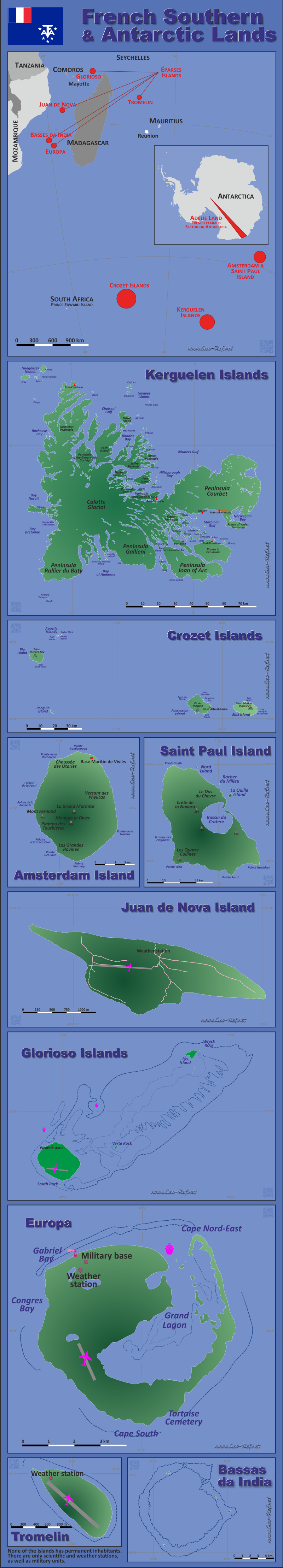
French Antarctic Lands - Click on the map to get a enlarged image in PDF format! Other language versions are easy to generate, the description is in an own layer
Statistical Data - Population density according to the administrative structureThe population data in the table below is a estimation for 2012. The islands are mainly used for scientific and military purposes, without permanent settlement. Click on the column header brings the table in order of the column header. The default order is the Islands name.
|
||||||||||||||||||||||||||||||||||||||||||||||||||||||||||||||||||||||||||||||||||||||||||||||

 |
If you have suggestions to include other information or you find missed links, please inform us! Click here ... |
International Border disputes
Expand list
See also neighboring states
Antarctica - Comoros - France - Heard Island & McDonalds - Madagascar - Mauritius - Mayotte - Mozambique - Reunion - Seychelles - South Africa - Tanzania
Fast selection
List of international
organisations
and treaties
Existing
thematical maps
Poulation density for 2007
Link-Collection
Country data
Terres australes française - Official Site
International data
Special data
External links change quickly - If you get a link error - Please inform us!