| |
Islamic Republic of Mauritania
|
| Capital |
Currency | Government system |
|---|
| Nouakchott |
Ouguiya (MRO) |
Presidential system |
| Official language | Region |
Population |
|---|
| Arabic |
Africa |
Census 2023 - 5 343 800 |
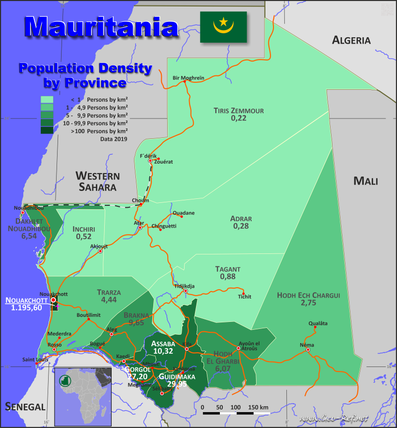
Country map - Administrative structure - Population density of Mauritania
Mauritania - Click on the map to get a enlarged image in PDF format!
Other language versions are easy to generate, the description is in an own layer
Conditions for thematic maps with your own data and logotype
Delivery as printable file by e-mail or plot by post office |
|---|
| Layer | |
| Province: | yes |
| Streets: | yes |
| Infrastructure: | yes |
| Rivers: | yes |
|
| Size | bis A2 |
| Supply in | 7 working days |
| Price |
| 1 bis 3 | 65 € |
| > 3 | On request |
|
 |
All information published herein is free usable quoting the source,
including the maps, if they are not modified |
|---|
Statistical Data - Population density according to the administrative structure
The population data in the table below is the census data from 2023, last available data.
Click on the column header brings the table in order of the column header. The default order is the Region name.
| Region |
ISO
3166-2 |
Arabe |
Capital |
Area
(km²) |
Population |
Density
(pers/km²) |
|---|
| Total |
|
|
|
1 040 645 |
5 343 800 |
5,1 |
|---|
| Last update: 02/01/2021 - 14:16:51 |
| Adrar |
MR-07 |
ادرار |
Atar |
222 107 |
74 900 |
0,3 |
| Assaba |
MR-03 |
العصابة |
Kiffa |
35 985 |
489 300 |
13,6 |
| Brakna |
MR-05 |
براكنة |
Aleg |
33 328 |
424 700 |
12,7 |
| Dakhlet Nouadhibou |
MR-08 |
داخلتانواديبو |
Nouadhibou |
37 794 |
195 900 |
5,2 |
| Gorgol |
MR-04 |
غورغول |
Kaédi |
13 600 |
486 600 |
35,8 |
| Guidimaka |
MR-10 |
غيديماغا |
Sélibaby |
10 818 |
400 100 |
37,0 |
| Hodh Ech Chargui |
MR-01 |
الحوضالغربى |
Néma |
182 265 |
684 500 |
3,8 |
| Hodh El Gharbi |
MR-02 |
الحوضالشرقى |
Aioun el Atrouss |
50 248 |
439 300 |
8,7 |
| Inchiri |
MR-12 |
انشيرى |
Akjoujt |
31 582 |
31 400 |
1,0 |
| Nouakchott |
MR-NKC |
انواكشوط |
Nouakchott |
1 185 |
1 558 100 |
1 314,9 |
| Tagant |
MR-00 |
تكانت |
Tidjikdja |
98 186 |
124 500 |
1,3 |
| Tiris Zemmour |
MR-11 |
تيرسزمور |
Zouérate |
257 783 |
84 200 |
0,3 |
| Trarza |
MR-06 |
اترارزه |
Rosso |
65 764 |
350 300 |
5,3 |
The regiones are divided into departments , the data of which are shown in the table below.
| Department |
Own |
Region |
Capital |
Area
(km²) |
Population |
Density
(pers/km²) |
|---|
| Total |
|
|
|
1 040 645 |
4 927 530 |
4,7 |
|---|
| Last update: 02/01/2021 - 14:16:51 |
| Adel Bagrou |
MR-01-01 |
Hodh Ech Chargui |
Adel Bagrou |
5 317 |
72 855 |
13,7 |
| Aioun El Atrouss |
MR-02-01 |
Hodh El Gharbi |
Aioun El Atrouss |
17 746 |
78 229 |
4,4 |
| Akjoujt |
MR-12-01 |
Inchiri |
Akjoujt |
13 422 |
18 138 |
1,4 |
| Aleg |
MR-05-01 |
Brakna |
Aleg |
8 460 |
75 856 |
9,0 |
| Amourj |
MR-01-02 |
Hodh Ech Chargui |
Amourj |
3 794 |
78 148 |
20,6 |
| Aoujeft |
MR-07-01 |
Adrar |
Aoujeft |
24 516 |
13 877 |
0,6 |
| Atar |
MR-07-02 |
Adrar |
Atar |
21 678 |
47 364 |
2,2 |
| Bababé |
MR-05-02 |
Brakna |
Bababé |
1 189 |
43 410 |
36,5 |
| Barkewol |
MR-03-01 |
Assaba |
Barkewol |
6 449 |
109 237 |
16,9 |
| Bassikounou |
MR-01-03 |
Hodh Ech Chargui |
Bassikounou |
12 272 |
123 337 |
10,1 |
| Bennechab |
MR-12-02 |
Inchiri |
Bennechab |
18 160 |
11 346 |
0,6 |
| Birmoguren |
MR-11-01 |
Tiris Zemmour |
Birmoguren |
87 401 |
5 126 |
0,1 |
| Boghé |
MR-05-03 |
Brakna |
Boghé |
1 722 |
85 333 |
49,6 |
| Boumdeid |
MR-03-02 |
Assaba |
Boumdeid |
4 324 |
10 747 |
2,5 |
| Boutilimit |
MR-06-01 |
Trarza |
Boutilimit |
32 501 |
66 999 |
2,1 |
| Chami |
MR-08-01 |
Dakhlet Nouadhibou |
Chami |
22 668 |
7 382 |
0,3 |
| Chinguetti |
MR-07-03 |
Adrar |
Chinguetti |
57 703 |
6 549 |
0,1 |
| Djiguenni |
MR-01-04 |
Hodh Ech Chargui |
Djiguenni |
5 234 |
91 605 |
17,5 |
| F´Derick |
MR-11-02 |
Tiris Zemmour |
F´Derick |
169 684 |
11 623 |
0,1 |
| Ghabou |
MR-10-01 |
Guidimaka |
Ghabou |
3 383 |
113 669 |
33,6 |
| Guerou |
MR-03-03 |
Assaba |
Guerou |
2 801 |
67 964 |
24,3 |
| Kaédi |
MR-04-01 |
Gorgol |
Kaédi |
2 355 |
120 660 |
51,2 |
| Kankossa |
MR-03-04 |
Assaba |
Kankossa |
10 369 |
117 392 |
11,3 |
| Keurmacen |
MR-06-02 |
Trarza |
Keurmacen |
2 577 |
33 488 |
13,0 |
| Kiffa |
MR-03-05 |
Assaba |
Kiffa |
12 042 |
146 464 |
12,2 |
| Kobenni |
MR-02-02 |
Hodh El Gharbi |
Kobenni |
8 924 |
135 158 |
15,1 |
| Lexeiba 1 |
MR-04-02 |
Gorgol |
Lexeiba 1 |
1 771 |
41 267 |
23,3 |
| M´Bagne |
MR-05-06 |
Brakna |
M´Bagne |
672 |
52 865 |
78,7 |
| M´Bout |
MR-04-04 |
Gorgol |
M´Bout |
5 504 |
132 464 |
24,1 |
| Maghama |
MR-04-03 |
Gorgol |
Maghama |
2 275 |
90 891 |
40,0 |
| Magta-Lahjar |
MR-05-04 |
Brakna |
Magta-Lahjar |
13 817 |
79 046 |
5,7 |
| Mal |
MR-05-05 |
Brakna |
Mal |
7 468 |
54 800 |
7,3 |
| Mederdra |
MR-06-03 |
Trarza |
Mederdra |
6 472 |
35 108 |
5,4 |
| Monguel |
MR-04-05 |
Gorgol |
Monguel |
1 695 |
57 208 |
33,8 |
| Moudjeria |
MR-09-01 |
Tagant |
Moudjeria |
11 945 |
57 936 |
4,9 |
| N´Beiket Lehwach |
MR-01-05 |
Hodh Ech Chargui |
N´Beiket Lehwach |
27 946 |
12 652 |
0,5 |
| Néma |
MR-01-06 |
Hodh Ech Chargui |
Néma |
9 449 |
121 408 |
12,8 |
| Nouadhibou |
MR-08-02 |
Dakhlet Nouadhibou |
Nouadhibou |
15 126 |
177 077 |
11,7 |
| Nouakchott-Nord |
MR-14 |
Nouakchott |
Nouakchott |
219 |
614 465 |
2 805,8 |
| Nouakchott-Ouest |
MR-13 |
Nouakchott |
Nouakchott |
624 |
204 881 |
328,3 |
| Nouakchott-Sud |
MR-15 |
Nouakchott |
Nouakchott |
342 |
627 415 |
1 834,5 |
| Ouad Naga |
MR-06-04 |
Trarza |
Ouad Naga |
17 671 |
24 605 |
1,4 |
| Ouadane |
MR-07-04 |
Adrar |
Ouadane |
118 210 |
3 833 |
0,0 |
| Oualata |
MR-01-07 |
Hodh Ech Chargui |
Oualata |
106 847 |
12 842 |
0,1 |
| Ould Yengé |
MR-10-02 |
Guidimaka |
Ould Yengé |
3 554 |
92 582 |
26,1 |
| R´Kiz |
MR-06-05 |
Trarza |
R´Kiz |
2 838 |
49 564 |
17,5 |
| Rosso |
MR-06-06 |
Trarza |
Rosso |
1 407 |
70 403 |
50,0 |
| Sélibabi |
MR-10-03 |
Guidimaka |
Sélibabi |
1 678 |
99 118 |
59,1 |
| Tamchekett |
MR-02-03 |
Hodh El Gharbi |
Tamchekett |
13 249 |
43 936 |
3,3 |
| Tékane |
MR-06-07 |
Trarza |
Tékane |
2 298 |
43 736 |
19,0 |
| Tichitt |
MR-09-02 |
Tagant |
Tichitt |
67 001 |
4 490 |
0,1 |
| Tidjikdja |
MR-09-03 |
Tagant |
Tidjikdja |
19 240 |
52 334 |
2,7 |
| Timbedra |
MR-01-08 |
Hodh Ech Chargui |
Timbedra |
11 406 |
112 796 |
9,9 |
| Tintane |
MR-02-04 |
Hodh El Gharbi |
Tintane |
7 994 |
98 188 |
12,3 |
| Touil |
MR-02-05 |
Hodh El Gharbi |
Touil |
2 335 |
47 578 |
20,4 |
| Wompou |
MR-10-04 |
Guidimaka |
Wompou |
2 203 |
57 706 |
26,2 |
| Zouerate |
MR-11-03 |
Tiris Zemmour |
Zouerate |
698 |
62 380 |
89,4 |
Membership in international organisations and treaties
Expand list
Political Alliances
Regional Unions
Military alliances/Arms control
Law enforcement
Business Alliances
Fishery
Financial
Free Trade Area, Internal Market
Technical alliances
Transport
Cientific
Humanitarian Unions
Cultural Unions
 |
If you have suggestions to include other information or you find missed links, please inform us!
Click here ... |
International Border disputes
Expand list
|
Fast selection
List of international
organisations
and treaties
Existing
thematical maps
|
