Mobil Version header


Democratic Republic of the Congo

Capital CurrencyGovernment system
Kinshasa Congolese franc (CDF) Semi-presidential system
Official languageRegion Population
French Africa Estimation 2020 - 105 586 600

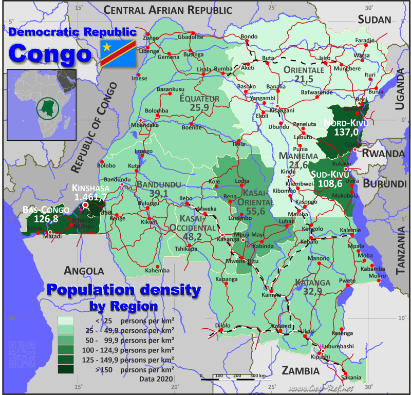
Country map - Administrative structure - Population density of Congo - Kinshasa

Map Congo - Kinshasa - Administrative division - Population density 2020

Congo - Kinshasa - Click on the map to get a enlarged image in PDF format!

Other language versions are easy to generate, the description is in an own layer

Conditions for thematic maps with your own data and logotype
Delivery as printable file by e-mail or plot by post office
Layer 
Province:yes
Streets:yes
Infrastructure:yes
Rivers:yes
Sizebis A2
Supply in7 working days
Price
1 bis 365 €
> 3On request
Buy
All information published herein is free usable quoting the source,
including the maps, if they are not modified

Statistical Data - Population density according to the administrative structure

The population data in the table below is a estimation for 2020.

Click on the column header brings the table in order of the column header. The default order is the Region name.

Region ISO
3166-2
Capital Area
(km²)
Population Density
(pers/km²)
Total     2 345 004 105 586 600 45,0
Last update: 01/10/2024 - 02:23:38
Bandundu CD-BN Bandundu 295 658 11555100 39,1
Bas-Congo CD-BC Matadi 53 920 6838500 126,8
Équateur CD-EQ Mbandaka 403 292 10444200 25,9
Kasai-Occidental CD-KW Kananga 154 742 7462300 48,2
Kasai-Oriental CD-KE Mbuji-Mayi 170 238 9459600 55,6
Katanga CD-KA Lubumbashi 496 877 16357100 32,9
Kinshasa City CD-KN Kinshasa 9 965 14565700 1 461,7
Maniema CD-MA Kindu 132 520 2856300 21,6
Nord-Kivu CD-NK Goma 59 483 8147400 137,0
Orientale CD-OR Kisangani 503 239 10834000 21,5
Sud-Kivu CD-SK Bukavu 65 070 7066400 108,6


The following table shows the regions divided into provinces. Deviations in the population are due to missing data by provinces for 2015, data from 2010 were given in three cases and the value of 2016 was used for Kinshasa.

Province HASC Region Capital Area
(km²)
Population Density
(pers/km²)
Total       2 345 004 105 586 600 45,0
Last update: 01/10/2024 - 02:23:38
Bas-Uele CD-BU Orientale Buta 148 331 1 369 600 9,2
Équateur CD-EQ Équateur Mbandaka 103 902 1 856 000 17,9
Haut-Katanga CD-HK Katanga Lubumbashi 132 425 5 718 800 43,2
Haut-Lomami CD-HL Katanga Kamina 108 204 3 662 800 33,9
Haut-Uele CD-HU Orientale Isiro 89 683 2 242 500 25,0
Ituri CD-IT Orientale Bunia 65 658 4 392 200 66,9
Kasaï CD-KS Kasai-Occidental Tshikapa 93 784 3 417 000 36,4
Kasaï-Central CD-KC Kasai-Occidental Kananga 60 958 4 045 300 66,4
Kasaï-Oriental CD-KE Kasaï-Oriental Mbuji-Mayi 9 481 3 864 300 407,6
Kinshasa CD-KN Kinshasa Kinshasa 9 965 14 565 700 1 461,7
Kongo Central CD-BC Bas-Congo Matadi 53 920 6 838 500 126,8
Kwango CD-KG Bandundu Kenge 89 974 2 618 700 29,1
Kwilu CD-KL Bandundu Bandundu 78 219 6 682 300 85,4
Lomami CD-LO Kasaï-Oriental Kabinda 56 426 3 001 900 53,2
Lualaba CD-LU Katanga Kolwezi 121 308 3 183 300 26,2
Mai-Ndombe CD-MN Bandundu Inongo 127 465 2 254 100 17,7
Maniema CD-MA Maniema Kindu 132 520 2 856 300 21,6
Mongala CD-MO Équateur Lisala 58 141 2 114 100 36,4
Nord-Kivu CD-NK Nord-Kivu Goma 59 483 8 147 400 137,0
Nord-Ubangi CD-NU Équateur Gbadolite 56 644 1 542 500 27,2
Sankuru CD-SA Kasaï-Oriental Lusambo 104 331 2 593 400 24,9
Sud-Kivu CD-SK Sud-Kivu Bukavu 65 070 7 066 400 108,6
Sud-Ubangi CD-SU Équateur Gemena 51 648 2 987 100 57,8
Tanganyika CD-TA Katanga Kalemie 134 940 3 792 200 28,1
Tshopo CD-TO Orientale Kisangani 199 567 2 829 700 14,2
Tshuapa CD-TU Équateur Boende 132 957 1 944 500 14,6


Membership in international organisations and treaties

Expand list

Political Alliances

Regional Unions

Military alliances/Arms control

Law enforcement

Business Alliances

Fishery

Financial

Free Trade Area, Internal Market

Technical alliances

Transport

Cientific

Humanitarian Unions

Cultural Unions


Broken Link

If you have suggestions to include other information or you find missed links, please inform us! Click here ...


International Border disputes

Expand list

See also neighboring states

Angola - Burundi - Central African Republic - Congo - Brazaville - Rwanda - South Sudan - Uganda - Zambia


Fast selection


List of international
organisations
and treaties


Existing
thematical maps

  • Poulation density for 2020

Link-Collection

Country data

Official Web-Portal

National Law

Data Portal Democratic Republic of Congo

National Media

National Holydays
in German

Wikipedia

Diplomatic Relations

German Ministry
of Foreign Affairs

Spanish Foreign Ministry

OECD-iLibarary

CIA - World Factbook


International data

UN-Data

UN-Population Fund

IOM - International Organization
for Migration

UN Refugee Agency

World Health Organisation

UNESCO Profil

UN Children´s Fund

UNCTAD

World Bank

International
Monetary Fund

Development cooperation

USAID

EU AID


Special data

FAO - Statistics

FAO - Country Profile

UN Environment

IRENA
Alternative Energy

Meteorology and Hydrology

Human Development Index

relief
Disaster/Risk data

Amnesty International

Human Rights Watch

INTERPOL Congo - Kinshasa

Global Terrorism Database
historically see also:
Zaire


External links change quickly - If you get a link error - Please inform us!
Broken Link Report