| |
| Capital |
Currency | Government system |
|---|
| Khartoum |
Sudanese Pound (SDG) |
Presidential system |
| Official language | Region |
Population |
|---|
Arabic
English |
Africa |
Estimation 2018 - 41 984 700 |
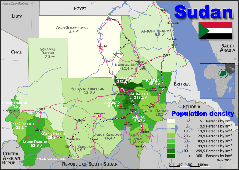
Country map - Administrative structure - Population density of Sudan
Sudan - Click on the map to get a enlarged image in PDF format!
Other language versions are easy to generate, the description is in an own layer
Conditions for thematic maps with your own data and logotype
Delivery as printable file by e-mail or plot by post office |
|---|
| Layer | |
| Province: | yes |
| Streets: | yes |
| Infrastructure: | yes |
| Rivers: | yes |
|
| Size | bis A2 |
| Supply in | 7 working days |
| Price |
| 1 bis 3 | 70 € |
| > 3 | On request |
|
 |
| Observation |
Territorial disputes marked |
All information published herein is free usable quoting the source,
including the maps, if they are not modified |
|---|
Statistical Data - Population density according to the administrative structure
The population data in the table below is a estimation for 2018.
Click on the column header brings the table in order of the column header. The default order is the Province name.
| Province |
ISO
3166-2 |
English |
Capital |
Area
(km²) |
Population |
Density
(pers/km²) |
|---|
| Total |
|
|
|
1 841 507 |
41 984 700 |
22,8 |
|---|
| Last update: 11/04/2020 - 00:43:49 |
| Al-Bahr al-Ahmar |
SD-RS |
Red Sea |
Bur Sudan |
218 887 |
1 482 100 |
6,8 |
| Al-Jazirah |
SD-GZ |
Al Gezira |
Wad Madani |
23 373 |
5 096 900 |
218,1 |
| Al-Khartum |
SD-KH |
Khartoum |
Al-Khartum |
22 142 |
7 993 900 |
361,0 |
| Al-Qadarif |
SD-GD |
Gadaref |
Al-Qadarif |
75 263 |
2 208 400 |
29,3 |
| An-Nil al-Abyad |
SD-NW |
White Nile |
Ad-Duwaym |
30 411 |
2 493 900 |
82,0 |
| An-Nil al-Azraq |
SD-NB |
Blue Nile |
Ad-Damazin |
45 844 |
1 108 400 |
24,2 |
| Ash-Shamaliyah |
SD-NO |
Northern |
Dunqula |
348 765 |
936 300 |
2,7 |
| Gharb al-Darfur |
SD-DW |
West Darfur |
Al-Junaynah |
23 000 |
1 024 500 |
44,5 |
| Gharb Kurdufan |
SD-GK |
West Kordofan |
Al-Fulah |
111 373 |
1 764 800 |
15,8 |
| Janub Darfur |
SD-DS |
South Darfur |
Nyala |
72 000 |
3 765 800 |
52,3 |
| Janub Kurdufan |
SD-KS |
South Kordofan |
Kaduqli |
79 470 |
1 300 700 |
16,4 |
| Kassala |
SD-KA |
Kassala |
Kassala |
36 710 |
2 519 100 |
68,6 |
| Nahr an-Nil |
SD-NR |
River Nile |
Ad-Damir |
122 123 |
1 511 400 |
12,4 |
| Sannar |
SD-SI |
Sennar |
Sannar |
37 844 |
1 918 700 |
50,7 |
| Shamal Darfur |
SD-DN |
North Darfur |
Al-Fashir |
320 000 |
2 305 000 |
7,2 |
| Shamal Kurdufan |
SD-KN |
North Kordofan |
Al-Ubayyid |
185 302 |
2 216 200 |
12,0 |
| Sharq Darfur |
SD-DE |
East Darfur |
Ad-du´ayn |
55 000 |
1 587 200 |
28,9 |
| Wasat Darfur |
SD-DC |
Central Darfur |
Zalingay |
34 000 |
751 400 |
22,1 |
Membership in international organisations and treaties
Expand list
Political Alliances
Regional Unions
Military alliances/Arms control
Law enforcement
Business Alliances
Fishery
Financial
Free Trade Area, Internal Market
Technical alliances
Transport
Cientific
Humanitarian Unions
Cultural Unions
 |
If you have suggestions to include other information or you find missed links, please inform us!
Click here ... |
International Border disputes
Expand list
|
Fast selection
List of international
organisations
and treaties
Existing
thematical maps
|
