| |
| Capital |
Currency | Government system |
|---|
| Cayenne |
Euro (EUR) |
Presidential system |
| Official language | Region |
Population |
|---|
| French |
South America |
Estimation 2021 - 286 618 |
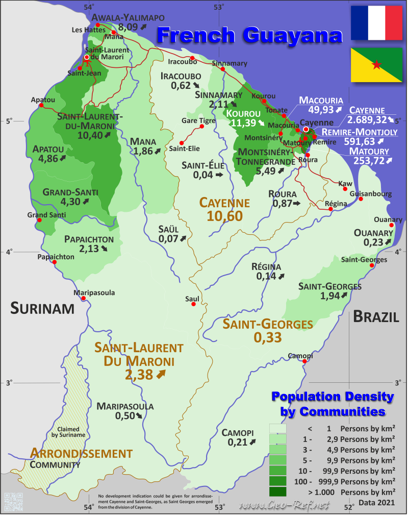
Country map - Administrative structure - Population density of French Guiana
French Guiana - Click on the map to get a enlarged image in PDF format!
Other language versions are easy to generate, the description is in an own layer
Conditions for thematic maps with your own data and logotype
Delivery as printable file by e-mail or plot by post office |
|---|
| Layer | |
| Province: | yes |
| Streets: | yes |
| Infrastructure: | yes |
| Rivers: | yes |
|
| Size | bis A2 |
| Supply in | 7 working days |
| Price |
| 1 bis 3 | 50 € |
| > 3 | On request |
|
 |
All information published herein is free usable quoting the source,
including the maps, if they are not modified |
|---|
Statistical Data - Population density according to the administrative structure
The population data in the table below is a estimation for 2021.
French Guyana is considered by France as an over sea Arrondissement. An classification according ISO 3166-2 doesn't exist.
Click on the column header brings the table in order of the column header. The default order is the Arrondissement name.
| Arrondissement |
INSEE |
Capital |
Area
(km²) |
Population |
Density
(pers/km²) |
|---|
| Total |
|
|
83 544,9 |
286 618 |
3,43 |
|---|
| Last update: 17/01/2023 - 02:14:49 |
| Cayenne |
FR-GF-1 |
Cayenne |
17 028,9 |
180493 |
10,60 |
| Saint-Georges |
FR-GF-2 |
Saint-Georges |
25 560,0 |
8557 |
0,33 |
| Saint-Laurent-du-Maroni |
FR-GF-3 |
Saint-Laurent-du-Maroni |
40 956,0 |
97568 |
2,38 |
Die Arrondissements sind in Gemeinden aufgeteilt, die in der nächsten Tabelle dargestellt sind. Anstelle der nicht vorhandenen ISO 3166-2-Klassifizierung wird die französische INSEE-Kodifizierung verwendet.
| Community |
INSEE |
Arrondissement |
Capital |
Area
(km²) |
Population |
Density
(pers/km²) |
|---|
| Total |
|
|
|
83 544,9 |
286 618 |
3,43 |
|---|
| Last update: 17/01/2023 - 02:14:49 |
| Apatou |
97360 |
Saint-Laurent |
Apatou |
2 020,0 |
9818 |
4,86 |
| Awala-Yalimapo |
97361 |
Saint-Laurent |
Awala-Yalimapo |
187,4 |
1516 |
8,09 |
| Camopi |
97356 |
Saint-Georges |
Camopi |
10 030,0 |
2146 |
0,21 |
| Cayenne |
97302 |
Cayenne |
Cayenne |
23,6 |
63468 |
2 689,32 |
| Grand-Santi |
97357 |
Saint-Laurent |
Grand-Santi |
2 123,0 |
9120 |
4,30 |
| Iracoubo |
97303 |
Cayenne |
Iracoubo |
2 762,0 |
1707 |
0,62 |
| Kourou |
97304 |
Cayenne |
Kourou |
2 160,0 |
24612 |
11,39 |
| Macouria |
97305 |
Cayenne |
Macouria |
377,5 |
18847 |
49,93 |
| Mana |
97306 |
Saint-Laurent |
Mana |
6 332,6 |
11764 |
1,86 |
| Maripasoula |
97353 |
Saint-Laurent |
Maripasoula |
18 360,0 |
9177 |
0,50 |
| Matoury |
97307 |
Cayenne |
Matoury |
137,2 |
34810 |
253,72 |
| Montsinéry-Tonnegrande |
97313 |
Cayenne |
Montsinéry-Tonnegrande |
600,0 |
3295 |
5,49 |
| Ouanary |
97314 |
Saint-Georges |
Ouanary |
1 080,0 |
251 |
0,23 |
| Papaichton |
97362 |
Saint-Laurent |
Papaichton |
2 628,0 |
5606 |
2,13 |
| Régina |
97301 |
Saint-Georges |
Régina |
12 130,0 |
1655 |
0,14 |
| Remire-Montjoly |
97309 |
Cayenne |
Remire-Montjoly |
46,1 |
27274 |
591,63 |
| Roura |
97310 |
Cayenne |
Roura |
3 902,5 |
3409 |
0,87 |
| Saint-Élie |
97358 |
Cayenne |
Saint-Élie |
5 680,0 |
241 |
0,04 |
| Saint-Georges |
97308 |
Saint-Georges |
Saint-Georges |
2 320,0 |
4505 |
1,94 |
| Saint-Laurent-du-Maroni |
97311 |
Saint-Laurent |
Saint-Laurent-du-Maroni |
4 830,0 |
50250 |
10,40 |
| Saül |
97352 |
Saint-Laurent |
Saül |
4 475,0 |
317 |
0,07 |
| Sinnamary |
97312 |
Cayenne |
Sinnamary |
1 340,0 |
2830 |
2,11 |
Membership in international organisations and treaties
Expand list
Political Alliances
Technical alliances
 |
If you have suggestions to include other information or you find missed links, please inform us!
Click here ... |
International Border disputes
Expand list
Land boundaries
Maritime boundaries
|
Fast selection
List of international
organisations
and treaties
Existing
thematical maps
|
