| |
| Capital |
Moneda | Sistema de gobierno |
|---|
| Harare |
Dólar Estadounidense (USD) |
Sistema presidencial |
| Idioma oficial language | Región |
Población |
|---|
Shona
Inglés
y lotros lenguajes locales |
Áfica |
Census 2022 - 15 178 957 |
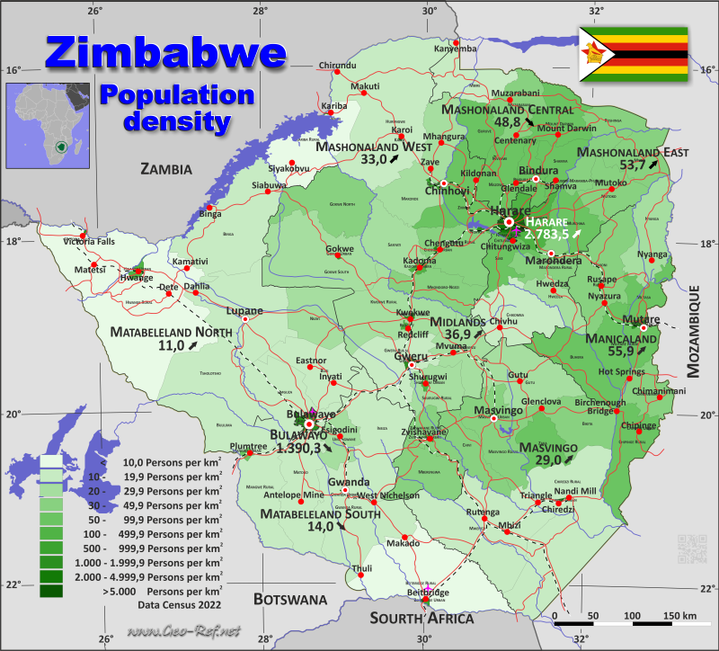
Mapa de la estructura administrativa - Densidad de población de Zimbabue
Zimbabue Double clic para agrandar el mapa en formato PDF!
Otra versión de lenguajes es posible de generar fácilmente, los descriptores de ciudades y provincias se encuentran en una capa separada.
Condiciones para la elaboración de mapas temáticos con sus propios datos
y su logotipo. Entrega como archivo imprimible por e-mail o como plot por oficina de correos |
|---|
| Capas | |
| Provincias: | si |
| Calles: | si |
| Infraestructura: | si |
| Rios: | si |
|
| Tamaño | bis A2 |
| Entrega | 7 días laborables |
| Price |
| 1 bis 3 | 70 € |
| > 3 | ¡Consúltenos por favor! |
|
 |
Toda la información publicada aquí se puede utilizar libre, citando la fuente.
Esto incluye los mapas, si estas no se modifica. |
|---|
Datos estatisticos - de acuerdo a la estructura admnistrativa
Los datos de población de la tabla abajo del censo de 2022, última data disponble.
Pincha en el encabezado de la tabla para ordenarla en el orden del criterio seleccionado. El orden por Provincia es preestablecido.
| Provincia |
ISO
3166-2 |
Capital |
Area
(km²) |
Population |
Density
(pers/km²) |
|---|
| Total |
|
|
390 770 |
15 178 957 |
38,8 |
|---|
| Last update: 04.11.2025 - 00:43:59 |
| Bulawayo |
ZW-BU |
Bulawayo |
546 |
665 952 |
1 219,7 |
| Harare |
ZW-HA |
Harare |
939 |
2 427 231 |
2 584,9 |
| Manicaland |
ZW-MA |
Mutare |
35 848 |
2 037 703 |
56,8 |
| Mashonaland Central |
ZW-MC |
Bindura |
28 194 |
1 384 891 |
49,1 |
| Mashonaland East |
ZW-ME |
Marondera |
32 170 |
1 731 173 |
53,8 |
| Mashonaland West |
ZW-MW |
Chinhoyi |
57 675 |
1 893 584 |
32,8 |
| Masvingo |
ZW-MV |
Masvingo |
56 457 |
1 638 528 |
29,0 |
| Matabeleland North |
ZW-MN |
Lupane |
75 455 |
827 645 |
11,0 |
| Matabeleland South |
ZW-MS |
Gwanda |
54 124 |
760 345 |
14,0 |
| Midlands |
ZW-MI |
Gweru |
49 362 |
1 811 905 |
36,7 |
Las provincias se dividen en distritos,cuyos datos se muestran en la siguiente tabla.
| Distrito |
Own |
Province |
Capital |
Área
(km²) |
Población |
Densidad
(pers/km²) |
|---|
| Total |
|
|
|
390 770 |
15 178 957 |
38,8 |
|---|
| Última actualización: 04.11.2025 - 00:43:59 |
| Beitbridge Rural |
MS-01 |
Matabeleland South |
Beitbridge |
12 719 |
94 001 |
7,4 |
| Beitbridge Urban |
MS-02 |
Matabeleland South |
Beitbridge |
89 |
58 574 |
658,1 |
| Bikita |
MV-01 |
Masvingo |
Bikita |
5 180 |
176 835 |
34,1 |
| Bindura Rural |
MC-01 |
Mashonaland Central |
Bindura |
2 242 |
169 841 |
75,8 |
| Bindura Urban |
MC-02 |
Mashonaland Central |
Bindura |
20 |
51 394 |
2 569,7 |
| Binga |
MN-01 |
Matabeleland North |
Binga |
13 338 |
159 982 |
12,0 |
| Bubi |
MN-02 |
Matabeleland North |
Bubi |
6 079 |
74 084 |
12,2 |
| Buhera |
MA-01 |
Manicaland |
Buhera |
5 357 |
271 920 |
50,8 |
| Bulawayo |
BU-01 |
Bulawayo |
Bulawayo |
546 |
665 952 |
1 219,7 |
| Bulilima |
MS-03 |
Matabeleland South |
Bulilima |
6 439 |
85 600 |
13,3 |
| Chegutu Rural |
MW-01 |
Mashonaland West |
Chegutu |
5 329 |
178 911 |
33,6 |
| Chegutu Urban |
MW-02 |
Mashonaland West |
Chegutu |
41 |
66 260 |
1 616,1 |
| Chikomba |
ME-01 |
Mashonaland East |
Chikomba |
6 503 |
123 932 |
19,1 |
| Chimanimani |
MA-02 |
Manicaland |
Chimanimani |
3 345 |
153 619 |
45,9 |
| Chinhoyi |
MW-03 |
Mashonaland West |
Chinhoyi |
150 |
103 657 |
691,0 |
| Chipinge Rural |
MA-03 |
Manicaland |
Chipinge |
5 220 |
375 259 |
71,9 |
| Chipinge Urban |
MA-04 |
Manicaland |
Chipinge |
29 |
34 959 |
1 205,5 |
| Chiredzi Rural |
MV-02 |
Masvingo |
Chiredzi |
17 401 |
303 503 |
17,4 |
| Chiredzi Urban |
MV-03 |
Masvingo |
Chiredzi |
22 |
40 457 |
1 839,0 |
| Chirumhanzu |
MI-01 |
Midlands |
Chirumhanzu |
4 749 |
95 272 |
20,1 |
| Chitungwiza |
HA-01 |
Harare |
Harare |
49 |
371 246 |
7 576,4 |
| Chivi |
MV-04 |
Masvingo |
Chivi |
3 543 |
172 979 |
48,8 |
| Epworth |
HA-02 |
Harare |
Harare |
35 |
206 368 |
5 896,2 |
| Gokwe North |
MI-02 |
Midlands |
Gokwe |
7 268 |
249 723 |
34,4 |
| Gokwe South |
MI-03 |
Midlands |
Gokwe |
11 124 |
317 554 |
28,5 |
| Gokwe Urban |
MI-04 |
Midlands |
Gokwe |
19 |
33 073 |
1 740,7 |
| Goromonzi |
ME-02 |
Mashonaland East |
Goromonzi |
2 520 |
386 203 |
153,3 |
| Guruve |
MC-03 |
Mashonaland Central |
Guruve |
2 994 |
153 606 |
51,3 |
| Gutu |
MV-05 |
Masvingo |
Gutu |
7 054 |
208 149 |
29,5 |
| Gwanda Rural |
MS-04 |
Matabeleland South |
Gwanda |
10 712 |
124 548 |
11,6 |
| Gwanda Urban |
MS-05 |
Matabeleland South |
Gwanda |
23 |
27 143 |
1 180,1 |
| Gweru Rural |
MI-05 |
Midlands |
Gweru |
5 889 |
121 712 |
20,7 |
| Gweru Urban |
MI-06 |
Midlands |
Gweru |
164 |
161 294 |
983,5 |
| Harare Rural |
HA-03 |
Harare |
Harare |
195 |
357 863 |
1 835,2 |
| Harare Urban |
HA-04 |
Harare |
Harare |
660 |
1 491 754 |
2 260,2 |
| Hurungwe (Karoi Rural) |
MW-04 |
Mashonaland West |
Karoi |
19 843 |
390 897 |
19,7 |
| Hwange Rural |
MN-03 |
Matabeleland North |
Hwange |
26 974 |
69 357 |
2,6 |
| Hwange Urban |
MN-04 |
Matabeleland North |
Hwange |
310 |
40 241 |
129,8 |
| Hwedza |
ME-03 |
Mashonaland East |
Hwedza |
2 560 |
74 870 |
29,2 |
| Insiza |
MS-06 |
Matabeleland South |
Insiza |
8 221 |
122 903 |
14,9 |
| Kadoma Urban |
MW-05 |
Mashonaland West |
Kadoma |
254 |
117 381 |
462,1 |
| Kariba Rural |
MW-06 |
Mashonaland West |
Kariba |
8 191 |
45 774 |
5,6 |
| Kariba Urban |
MW-07 |
Mashonaland West |
Kariba |
24 |
27 910 |
1 162,9 |
| Karoi |
MW-08 |
Mashonaland West |
Karoi |
17 |
37 564 |
2 209,6 |
| Kwekwe Rural |
MI-07 |
Midlands |
Kwekwe |
8 748 |
197 062 |
22,5 |
| Kwekwe Urban |
MI-08 |
Midlands |
Kwekwe |
86 |
119 863 |
1 393,8 |
| Lupane |
MN-05 |
Matabeleland North |
Lupane |
10 107 |
107 248 |
10,6 |
| Makonde |
MW-09 |
Mashonaland West |
Makonde |
8 564 |
209 960 |
24,5 |
| Makoni |
MA-05 |
Manicaland |
Makoni |
7 834 |
288 441 |
36,8 |
| Mangwe Rural |
MS-07 |
Matabeleland South |
Mangwe |
5 722 |
65 562 |
11,5 |
| Mangwe Urban (Plumtree) |
MS-08 |
Matabeleland South |
Mangwe |
174 |
14 460 |
83,1 |
| Marondera Rural |
ME-04 |
Mashonaland East |
Marondera |
3 414 |
136 173 |
39,9 |
| Marondera Urban |
ME-05 |
Mashonaland East |
Marondera |
59 |
66 204 |
1 122,1 |
| Masvingo Rural |
MV-06 |
Masvingo |
Masvingo |
6 849 |
238 103 |
34,8 |
| Masvingo Urban |
MV-07 |
Masvingo |
Masvingo |
72 |
90 286 |
1 254,0 |
| Matobo |
MS-09 |
Matabeleland South |
Matobo |
7 245 |
95 694 |
13,2 |
| Mazowe |
MC-04 |
Mashonaland Central |
Mazowe |
4 354 |
293 363 |
67,4 |
| Mberengwa |
MI-09 |
Midlands |
Mberengwa |
5 066 |
208 458 |
41,1 |
| Mbire |
MC-05 |
Mashonaland Central |
Mbire |
4 696 |
83 720 |
17,8 |
| Mhondoro-Ngezi |
MW-10 |
Mashonaland West |
Mhondoro |
4 295 |
140 994 |
32,8 |
| Mount Darwin |
MC-06 |
Mashonaland Central |
Pfura |
4 596 |
240 728 |
52,4 |
| Mudzi |
ME-06 |
Mashonaland East |
Mudzi |
4 158 |
158 478 |
38,1 |
| Murehwa |
ME-07 |
Mashonaland East |
Murehwa |
3 556 |
205 440 |
57,8 |
| Mutare Rural |
MA-06 |
Manicaland |
Mutare |
5 523 |
306 760 |
55,5 |
| Mutare Urban |
MA-07 |
Manicaland |
Mutare |
191 |
224 804 |
1 177,0 |
| Mutasa |
MA-08 |
Manicaland |
Mutasa |
2 548 |
197 808 |
77,6 |
| Mutoko |
ME-08 |
Mashonaland East |
Mutoko |
4 050 |
161 091 |
39,8 |
| Muzarabani (Centenary) |
MC-07 |
Mashonaland Central |
Muzarabani |
4 266 |
134 076 |
31,4 |
| Mvurwi |
MC-08 |
Mashonaland Central |
Mvurwi |
3 |
15 646 |
5 215,3 |
| Mwenezi |
MV-08 |
Masvingo |
Mwenezi |
13 210 |
209 327 |
15,8 |
| Nkayi |
MN-06 |
Matabeleland North |
Nkayi |
4 831 |
112 471 |
23,3 |
| Norton |
MW-11 |
Mashonaland West |
Norton |
62 |
87 039 |
1 403,9 |
| Nyanga |
MA-09 |
Manicaland |
Nyanga |
5 781 |
146 227 |
25,3 |
| Redcliff |
MI-10 |
Midlands |
Redcliff |
113 |
41 526 |
367,5 |
| Rusape |
MA-10 |
Manicaland |
Rusape |
20 |
37 906 |
1 895,3 |
| Rushinga |
MC-09 |
Mashonaland Central |
Rushinga |
2 328 |
76 876 |
33,0 |
| Ruwa |
ME-09 |
Mashonaland East |
Ruwa |
40 |
94 078 |
2 352,0 |
| Sanyati |
MW-12 |
Mashonaland West |
Sanyati |
4 833 |
139 235 |
28,8 |
| Seke |
ME-10 |
Mashonaland East |
Seke |
2 637 |
200 478 |
76,0 |
| Shamva |
MC-10 |
Mashonaland Central |
Shamva |
2 695 |
165 641 |
61,5 |
| Shurugwi Rural |
MI-11 |
Midlands |
Shurugwi |
3 464 |
98 315 |
28,4 |
| Shurugwi Urban |
MI-12 |
Midlands |
Shurugwi |
134 |
23 304 |
173,9 |
| Tsholotsho |
MN-07 |
Matabeleland North |
Tsholotsho |
7 745 |
115 782 |
14,9 |
| Umguza |
MN-08 |
Matabeleland North |
Umguza |
6 043 |
113 265 |
18,7 |
| Umzingwane |
MS-10 |
Matabeleland South |
Umzingwane |
2 780 |
71 860 |
25,8 |
| Uzumba-Maramba-Pfungwe |
ME-11 |
Mashonaland East |
Murehwa |
2 673 |
124 226 |
46,5 |
| Victoria Falls |
MN-09 |
Matabeleland North |
Victoria Falls |
28 |
35 215 |
1 257,7 |
| Zaka |
MV-09 |
Masvingo |
Zaka |
3 126 |
198 889 |
63,6 |
| Zvimba |
MW-13 |
Mashonaland West |
Zvimba |
6 072 |
348 002 |
57,3 |
| Zvishavane Rural |
MI-13 |
Midlands |
Zvishavane |
2 476 |
85 035 |
34,3 |
| Zvishavane Urban |
MI-14 |
Midlands |
Zvishavane |
62 |
59 714 |
963,1 |
Membresía en organizaciones internacionales y tratados
Expandir lista
Political Alliances
Regional Unions
Military alliances/Arms control
Law enforcement
Business Alliances
Financial
Free Trade Area, Internal Market
Technical alliances
Transport
Cientific
Humanitarian Unions
Cultural Unions
 |
Si tiene sugerencias para incluir otra información o encuentra enlaces perdidos, infórmenos!
Pincha aquí ... |
Disputas fronterizas internacionales
Expandir lista
|
Selección rápida
Listado de
organisationes
y tratados
internationales
Mapas temáticos existentes
|
