| |
República de las Maldivas
|
| Capital |
Moneda | Sistema de gobierno |
|---|
| Malé |
Rufiyaa (MVR) |
Sistema presidencial |
| Idioma oficial language | Región |
Población |
|---|
| Maldivo |
Asia del Sur |
Census 2022 - 515 132 |
Mapa de la estructura administrativa - Densidad de población de Islas Maldivas
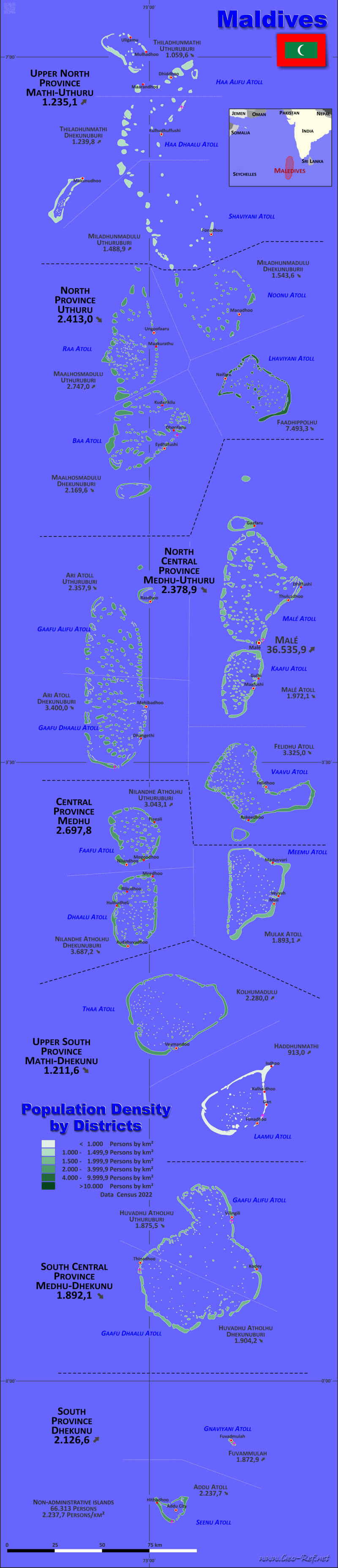
Islas Maldivas Double clic para agrandar el mapa en formato PDF!
Otra versión de lenguajes es posible de generar fácilmente, los descriptores de ciudades y provincias se encuentran en una capa separada.
Condiciones para la elaboración de mapas temáticos con sus propios datos
y su logotipo. Entrega como archivo imprimible por e-mail o como plot por oficina de correos |
|---|
| Capas | |
| Provincias: | si |
| Calles: | no |
| Infraestructura: | si |
| Rios: | no |
|
| Tamaño | bis A2 |
| Entrega | 7 días laborables |
| Price |
| 1 bis 3 | 75 € |
| > 3 | ¡Consúltenos por favor! |
|
 |
Toda la información publicada aquí se puede utilizar libre, citando la fuente.
Esto incluye los mapas, si estas no se modifica. |
|---|
Datos estatisticos - de acuerdo a la estructura admnistrativa
Los datos de población de la tabla abajo del censo de 2022, última data disponble.
Pincha en el encabezado de la tabla para ordenarla en el orden del criterio seleccionado. El orden por Provincia es preestablecido.
| Provincia |
ISO
3166-2 |
Capital |
Area
(km²) |
Population |
Density
(pers/km²) |
|---|
| Total |
|
|
199,4 |
515 132 |
2 583,4 |
|---|
| Last update: 01.06.2025 - 19:53:33 |
| Central |
MV-CE |
Kudahuvadhoo |
6,3 |
16996 |
2 697,8 |
| Malé |
MV-MLE |
Male |
5,8 |
211908 |
36 535,9 |
| Non-administrative islands |
MV-XX |
Male |
61,2 |
66313 |
1 083,5 |
| North |
MV-NO |
Felivaru |
20,6 |
49707 |
2 413,0 |
| North Central |
MV-NC |
Maafushi |
16,1 |
38301 |
2 378,9 |
| South |
MV-SU |
Hithadhoo |
16,1 |
34239 |
2 126,6 |
| South Central |
MV-SC |
Gan |
11,6 |
21948 |
1 892,1 |
| Upper North |
MV-UN |
Kulhudhuffushi |
41,1 |
50761 |
1 235,1 |
| Upper South |
MV-US |
Thinadhoo |
20,6 |
24959 |
1 211,6 |
La próxima tabla muestra la división de las provincias en distritos.
| Distrito |
ISO
3166-2 |
Province |
Capital |
Área
(km²) |
Población |
Densidad
(pers/km²) |
|---|
| Total |
|
|
|
199,4 |
515 132 |
2 583,4 |
|---|
| Última actualización: 01.06.2025 - 19:53:33 |
| Addu Atoll |
MV-AD |
South |
Hithadhoo |
11,2 |
25 062 |
2 237,7 |
| Ari Atoll Dhekunuburi |
MV-ADH |
North Central |
Mahibadhoo |
3,1 |
10 540 |
3 400,0 |
| Ari Atoll Uthuruburi |
MV-AA |
North Central |
Rasdhoo |
3,4 |
8 017 |
2 357,9 |
| Faadhippolhu |
MV-LH |
North |
Naifaru |
1,2 |
8 992 |
7 493,3 |
| Felidhu Atoll |
MV-V |
North Central |
Fulidhoo |
0,6 |
1 995 |
3 325,0 |
| Fuvammulah |
MV-GN |
South |
Fuvammulah |
4,9 |
9 177 |
1 872,9 |
| Haddhunmathi |
MV-L |
Upper South |
Fonadhoo |
16,1 |
14 699 |
913,0 |
| Huvadhu Atholhu Dhekunuburi |
MV-GDH |
South Central |
Thinadhoo |
6,7 |
12 758 |
1 904,2 |
| Huvadhu Atholhu Uthuruburi |
MV-GA |
South Central |
Viligili |
4,9 |
9 190 |
1 875,5 |
| Kolhumadulu |
MV-TH |
Upper South |
Veymandhoo |
4,5 |
10 260 |
2 280,0 |
| Maalhosmadulu Dhekunuburi |
MV-B |
North |
Eydhafushi |
4,9 |
10 631 |
2 169,6 |
| Maalhosmadulu Uthuruburi |
MV-R |
North |
Ugoofaaru |
6,4 |
17 581 |
2 747,0 |
| Malé |
|
Malé |
Malé |
5,8 |
211 908 |
36 535,9 |
| Malé Atoll |
MV-K |
North Central |
Thulusdhoo |
9,0 |
17 749 |
1 972,1 |
| Miladhunmadulu Dhekunuburi |
MV-N |
North |
Manadhoo |
8,1 |
12 503 |
1 543,6 |
| Miladhunmadulu Uthuruburi |
MV-SH |
Upper North |
Funadhoo |
9,2 |
13 698 |
1 488,9 |
| Mulak Atoll |
MV-M |
Central |
Muli |
2,9 |
5 490 |
1 893,1 |
| Nilandhe Atholhu Dhekunuburi |
MV-DH |
Central |
Kudahuvadhoo |
1,8 |
6 637 |
3 687,2 |
| Nilandhe Atholhu Uthuruburi |
MV-F |
Central |
Magoodhoo |
1,6 |
4 869 |
3 043,1 |
| Non-administrative islands |
MV-XX |
|
Malé |
61,2 |
66 313 |
1 083,5 |
| Thiladhunmathi Dhekunuburi |
MV-HDH |
Upper North |
Kulhudhuffushi |
18,1 |
22 440 |
1 239,8 |
| Thiladhunmathi Uthuruburi |
MV-HA |
Upper North |
Dhidhdhoo |
13,8 |
14 623 |
1 059,6 |
Membresía en organizaciones internacionales y tratados
Expandir lista
Political Alliances
Regional Unions
Military alliances/Arms control
Law enforcement
Business Alliances
Fishery
Financial
Free Trade Area, Internal Market
Technical alliances
Transport
Cientific
Humanitarian Unions
Cultural Unions
 |
Si tiene sugerencias para incluir otra información o encuentra enlaces perdidos, infórmenos!
Pincha aquí ... |
Disputas fronterizas internacionales
Expandir lista
Ver también los estados vecinos
India
|
Selección rápida
Listado de
organisationes
y tratados
internationales
Mapas temáticos existentes
|
