Mobil Version header


Pridnestrovian Moldavian Republic

Capital CurrencyGovernment system
Tiraspol Transnistrian Ruble (PRB) De facto government
Official languageRegion Population
Russiana
Moldovan
Ukrainian
Europe Census 2018 - 468 987

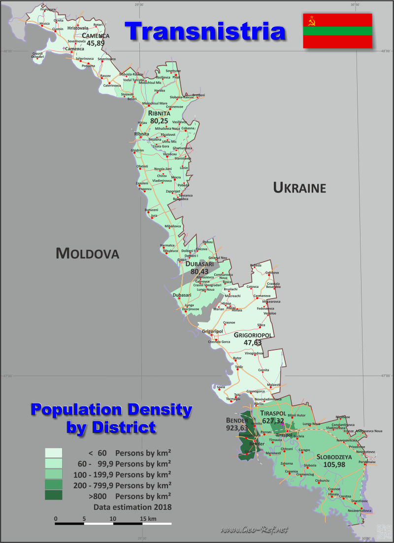
Country map - Administrative structure - Population density of Transnistria

Map Transnistria - Administrative division - Population density 2018

Transnistria - Click on the map to get a enlarged image in PDF format!

Other language versions are easy to generate, the description is in an own layer

Conditions for thematic maps with your own data and logotype
Delivery as printable file by e-mail or plot by post office
Layer 
Province:yes
Streets:yes
Infrastructure:yes
Rivers:yes
Sizebis A2
Supply in7 working days
Price
1 bis 370 €
> 3On request
Buy
All information published herein is free usable quoting the source,
including the maps, if they are not modified

Statistical Data - Population density according to the administrative structure

The population data in the table below is the census data from 2018, last available data.

Transnistria is a de facto state, which has declared itself in 1991 as independent, cleaved from Moldova. The country is only diplomatically recognized by 3 other de facto states.

A dedicated ISO 3166 code does not exist.

Click on the column header brings the table in order of the column header. The default order is the District name.

District ISO
3166-2
Capital Area
(km²)
Population Density
(pers/km²)
Total     3 663 468 987 128,02
Last update: 01/16/2024 - 22:31:39
Camenca n.d. Camenca 434,5 19 939 45,89
City of Bender n.d. Bender 97,3 89 869 923,63
City of Tiraspol  n.d. Tiraspol 205 128 600 627,32
Dubasari n.d. Dubasari 381,2 30 661 80,43
Grigoripol n.d. Grigoripol 822 39 155 47,63
Ribnita n.d. Ribnita 850,2 68 225 80,25
Slobodzeya n.d. Slobozia 873,2 92 538 105,98


Membership in international organisations and treaties

Expand list


Broken Link

If you have suggestions to include other information or you find missed links, please inform us! Click here ...


See also neighboring states

Moldova - Ukraine


Fast selection


List of international
organisations
and treaties


Existing
thematical maps

  • Poulation density for 2018

Link-Collection

Country data

Official Web-Portal

National Bureau of Statistics

Links national institutions

National Media

Wikipedia

Diplomatic Relations


International data


Special data

UN Environment

IRENA
Alternative Energy


External links change quickly - If you get a link error - Please inform us!

Broken Link Report