| |
Hong Kong Special Administrative Region of the People's Republic of China
|
| Capital |
Currency | Government system |
|---|
| Hong Kong |
Hong Kong Dollar (HKD) |
Special Administrative Region of China |
| Official language | Region |
Population |
|---|
Chinese
English |
Far East |
Census 2021 - 7 413 070 |
Country map - Administrative structure - Population density of Hong Kong SAR
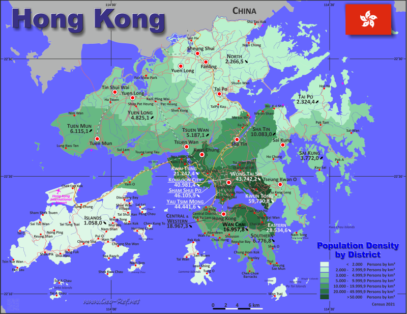
Hong Kong SAR - Click on the map to get a enlarged image in PDF format!
Other language versions are easy to generate, the description is in an own layer
Conditions for thematic maps with your own data and logotype
Delivery as printable file by e-mail or plot by post office |
|---|
| Layer | |
| Province: | yes |
| Streets: | yes |
| Infrastructure: | yes |
| Rivers: | yes |
|
| Size | bis A2 |
| Supply in | 7 working days |
| Price |
| 1 bis 3 | 90 € |
| > 3 | On request |
|
 |
All information published herein is free usable quoting the source,
including the maps, if they are not modified |
|---|
Statistical Data - Population density according to the administrative structure
The population data in the table below is the census data from 2021, last available data.
Currently no ISO 3166-2 codes are defined for Hong Kong.
Click on the column header brings the table in order of the column header. The default order is the Region name.
| Region |
HASC |
Capital |
Area
(km²) |
Population |
Density
(pers/km²) |
|---|
| Total |
|
|
1079,25 |
7 413 070 |
6 868,7 |
|---|
| Last update: 01/16/2024 - 22:31:38 |
| Hong Kong Island |
HK-I |
- |
79,68 |
1 195 529 |
15 004,1 |
| Kowloon |
HK-K |
- |
46,93 |
2 232 339 |
47 567,4 |
| New Territories |
HK-N |
- |
952,64 |
3 984 077 |
4 182,1 |
| On house boats |
- |
- |
0 |
1 125 |
0,0 |
The regions are divided into districts, which are shown in the following table in their assignment to the regions.
| District |
HASC |
Region |
Capital |
Area
(km²) |
Population |
Density
(pers/km²) |
|---|
| Total |
|
|
|
1 079,25 |
7 413 070 |
6 868,7 |
|---|
| Last update: 01/16/2024 - 22:31:38 |
| Central and Western |
HK CW |
Hong Kong Island |
Central (Victoria) |
12,44 |
235 953 |
18 967,3 |
| Eastern |
HK EA |
Hong Kong Island |
Sai Wan Ho |
18,56 |
529 603 |
28 534,6 |
| Islands |
HK IS |
New Territories |
Mui Wo, Cheung Chau |
175,12 |
185 282 |
1 058,0 |
| Kowloon City |
HK KC |
Kowloon |
Hung Hom |
10,02 |
410 634 |
40 981,4 |
| Kwai Tsing |
HK KI |
New Territories |
Kwai Chung |
23,34 |
495 798 |
21 242,4 |
| Kwun Tong |
HK KU |
Kowloon |
Kwun Tong |
11,27 |
673 166 |
59 730,8 |
| Living on house boats |
HK |
On house boats |
|
0,00 |
1 125 |
0,0 |
| North |
HK NO |
New Territories |
Fanling |
136,61 |
309 631 |
2 266,5 |
| Sai Kung |
HK SK |
New Territories |
Tseung Kwan O |
129,65 |
489 037 |
3 772,0 |
| Sha Tin |
HK ST |
New Territories |
Shatin Station |
68,71 |
692 806 |
10 083,0 |
| Sham Shui Po |
HK SS |
Kowloon |
Sham Shui Po |
9,35 |
431 090 |
46 105,9 |
| Southern |
HK SO |
Hong Kong Island |
Aberdeen |
38,85 |
263 278 |
6 776,8 |
| Tai Po |
HK TP |
New Territories |
Tai Po |
136,15 |
316 470 |
2 324,4 |
| Tsuen Wan |
HK TW |
New Territories |
Tsuen Wan |
61,71 |
320 094 |
5 187,1 |
| Tuen Mun |
HK TM |
New Territories |
Tuen Mun |
82,89 |
506 879 |
6 115,1 |
| Wan Chai |
HK WC |
Hong Kong Island |
Wan Chai |
9,83 |
166 695 |
16 957,8 |
| Wong Tai Sin |
HK WT |
Kowloon |
San Po Kong |
9,30 |
406 802 |
43 742,2 |
| Yau Tsim Mong |
HK YT |
Kowloon |
Mongkok |
6,99 |
310 647 |
44 441,6 |
| Yuen Long |
HK YL |
New Territories |
Yuen Long |
138,46 |
668 080 |
4 825,1 |
Membership in international organisations and treaties
Expand list
Law enforcement
Financial
Free Trade Area, Internal Market
Technical alliances
Transport
Cientific
Cultural Unions
 |
If you have suggestions to include other information or you find missed links, please inform us!
Click here ... |
|
Fast selection
List of international
organisations
and treaties
Existing
thematical maps
|
