| |
Collectivité de Saint-Barthélemy
|
| Capital |
Currency | Government system |
|---|
| Gustavia |
Euro (EUR) |
Dependent from France |
| Official language | Region |
Population |
|---|
| French |
Central America & Caribbean |
Estimation 2024 - 10 945 |
Country map - Administrative structure - Population density of Saint Barthélemy
Saint Barthélemy - Click on the map to get a enlarged image in PDF format!
Other language versions are easy to generate, the description is in an own layer
Conditions for thematic maps with your own data and logotype
Delivery as printable file by e-mail or plot by post office |
|---|
| Layer | |
| Province: | yes |
| Streets: | yes |
| Infrastructure: | yes |
| Rivers: | no |
|
| Size | bis A2 |
| Supply in | 7 working days |
| Price |
| 1 bis 3 | 60 € |
| > 3 | On request |
|
 |
All information published herein is free usable quoting the source,
including the maps, if they are not modified |
|---|
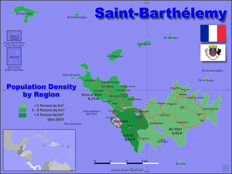
Statistical Data - Population density according to the administrative structure
The population data in the table below is a estimation for 2024.
No detailed data avialable.
Click on the column header brings the table in order of the column header. The default order is the District name.
| District |
ISO
3166-2 |
Capital |
Area
(km²) |
Population |
Density
(pers/km²) |
|---|
| Total |
|
|
20,9 |
10 945 |
523,7 |
|---|
| Last update: 01/02/2026 - 20:37:31 |
| Au Vent |
AVT |
Lorient |
11,6 |
4 520 |
389,7 |
| Centre |
CEN |
Gustavia |
3,4 |
2 855 |
839,7 |
| Sous le Vent |
SLV |
Corossol |
5,9 |
3 570 |
605,1 |
International Border disputes
Expand list
|
Fast selection
List of international
organisations
and treaties
Existing
thematical maps
|

