Federative Republic of Brazil
| Capital |
Currency | Government system |
|---|
| Brasília |
Real (BRL) |
Presidential system |
| Official language | Region |
Population |
|---|
| Portuguese |
South America |
Estimation 2025
213 421 037 |
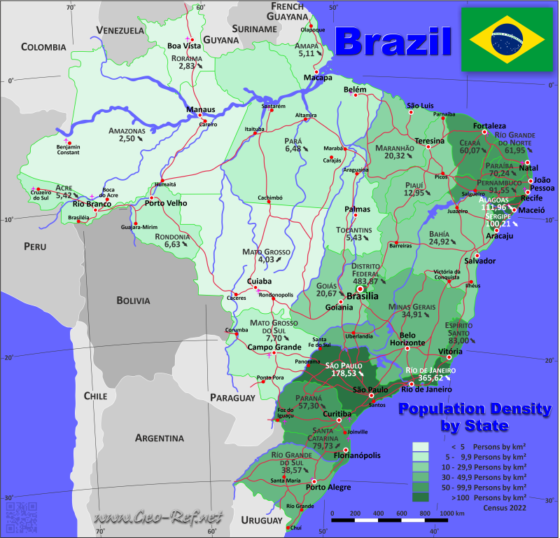
Country map - Administrative structure - Population density of Brazil

Brazil map - Click the map to get map as PDF file.
Other language versions are easy to generate, the descriptions are in own layers
Conditions for thematic maps with your own data and logotype
Delivery as printable file by e-mail or plot by post office
|
|---|
| Layers | |
| Provinces: | yes |
| Streets: | yes |
| Infrastructure: | yes |
| Rivers: | yes |
|
| Size | Till A2 |
| Delivery time | 7 working days | | Price |
| 1 bis 3 | 75 € | | > 3 | On request |
|
 |
All information published herein is free usable quoting the source,
including the maps, if they are not modified
|
|---|
Statistical data - Population density according to the administrative structure
The population data of the table below is an estimation form 2025, last available data.
Click on the column header brings the table in order of the column header.
The default order is the state name.
| State |
ISO
3166-2 |
Capital |
Area
(km²) |
Population |
Density
(pers/km²) |
| Total |
|
|
8 544 418 |
213 421 037 |
25,0 |
|---|
| Last update: 09/07/2025 - 20:59:48 |
|---|
| Acre |
BR-AC |
Rio Branco |
153 150 |
884 372 |
5,8 |
| Alagoas |
BR-AL |
Maceió |
27 933 |
3 220 848 |
115,3 |
| Amapá |
BR-AP |
Macapá |
143 454 |
806 517 |
5,6 |
| Amazonas |
BR-AM |
Manaus |
1 577 820 |
4 321 616 |
2,7 |
| Bahia |
BR-BA |
Salvador |
567 295 |
14 870 907 |
26,2 |
| Ceará |
BR-CE |
Fortaleza |
146 348 |
9 268 836 |
63,3 |
| Distrito Federal |
BR-DF |
Brasília |
5 822 |
2 996 899 |
514,8 |
| Espírito Santo |
BR-ES |
Vitória |
46 184 |
4 126 854 |
89,4 |
| Goiás |
BR-GO |
Goiânia |
341 290 |
7 423 629 |
21,8 |
| Maranhão |
BR-MA |
São Luís |
333 366 |
7 018 211 |
21,1 |
| Mato Grosso |
BR-MT |
Cuiabá |
906 807 |
3 893 659 |
4,3 |
| Mato Grosso do Sul |
BR-MS |
Campo Grande |
358 159 |
2 924 631 |
8,2 |
| Minas Gerais |
BR-MG |
Belo Horizonte |
588 384 |
21 393 441 |
36,4 |
| Pará |
BR-PA |
Belém |
1 253 165 |
8 711 196 |
7,0 |
| Paraíba |
BR-PB |
João Pessoa |
56 585 |
4 164 468 |
73,6 |
| Paraná |
BR-PR |
Curitiba |
199 709 |
11 890 517 |
59,5 |
| Pernambuco |
BR-PE |
Recife |
98 938 |
9 562 007 |
96,6 |
| Piauí |
BR-PI |
Teresina |
252 378 |
3 384 547 |
13,4 |
| Rio de Janeiro |
BR-RJ |
Rio de Janeiro |
43 910 |
17 223 547 |
392,2 |
| Rio Grande do Norte |
BR-RN |
Natal |
53 307 |
3 455 236 |
64,8 |
| Rio Grande do Sul |
BR-RS |
Porto Alegre |
282 062 |
11 233 263 |
39,8 |
| Rondônia |
BR-RO |
Porto Velho |
238 513 |
1 751 950 |
7,3 |
| Roraima |
BR-RR |
Boa Vista |
225 116 |
738 772 |
3,3 |
| Santa Catarina |
BR-SC |
Florianópolis |
95 443 |
8 187 029 |
85,8 |
| São Paulo |
BR-SP |
São Paulo |
248 809 |
46 081 801 |
185,2 |
| Sergipe |
BR-SE |
Aracaju |
22 050 |
2 299 425 |
104,3 |
| Tocantins |
BR-TO |
Palmas |
278 421 |
1 586 859 |
5,7 |
Existing thematic maps
|
External links change quickly - If you get a link error - Please inform us!
 |
Membership in international organisations and treaties
Expand list
Political Alliances
Regional Unions
Military alliances/Arms control
Law enforcement
Business Alliances
Fishery
Financial
Free Trade Area, Internal Market
Technical alliances
Environment
Transport
Cientific
Humanitarian Unions
Cultural Unions
 |
If you have suggestions to include other information or you find missed links, please inform us!
Click here ... |
International Border disputes
Expand list
Land boundaries
Maritime boundaries
See also neighboring states
|
| |


