Syrian Arab Republic
| Capital |
Currency | Government system |
|---|
| Damascus |
Syrian Pound (SYP) |
One-party system |
| Official language | Region |
Population |
|---|
| Arabic |
Middle East |
Census 2021
22 922 000 |
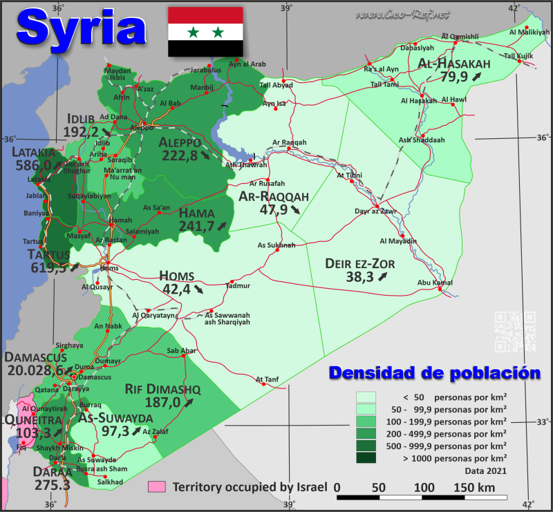
Country map - Administrative structure - Population density of Syria
Syria map - Click the map to get map as PDF file.
Other language versions are easy to generate, the descriptions are in own layers
Conditions for thematic maps with your own data and logotype
Delivery as printable file by e-mail or plot by post office
|
|---|
| Layers | |
| Provinces: | yes |
| Streets: | yes |
| Infrastructure: | yes |
| Rivers: | yes |
|
| Size | Till A2 |
| Delivery time | 7 working days | | Price |
| 1 bis 3 | 65 € | | > 3 | On request |
|
 |
All information published herein is free usable quoting the source,
including the maps, if they are not modified
|
|---|
Statistical data - Population density according to the administrative structure
The population data of the table below is census data from 2021, last available data.
Click on the column header brings the table in order of the column header.
The default order is the governorate name.
| Governorate |
ISO
3166-2 |
Arabic |
Capital |
Area
(km²) |
Population |
Density
(pers/km²) |
| Total |
|
|
|
185 677 |
22 922 000 |
123,5 |
|---|
| Last update: 01.10.2024 - 02:24:07 |
|---|
| Aleppo |
SY-HL |
حلب |
Aleppo |
18 482 |
4 118 000 |
222,8 |
| Al-Hasakah |
SY-HA |
الحسكة |
Al-Hasakah |
23 334 |
1 865 000 |
79,9 |
| Ar-Raqqah |
SY-RA |
الرقة |
Ar-Raqqah |
19 616 |
940 000 |
47,9 |
| As-Suwayda |
SY-SU |
السويداء |
As-Suwayda |
5 550 |
540 000 |
97,3 |
| Damascus |
SY-DI |
دِمَشق |
Damascus |
105 |
2 103 000 |
20 028,6 |
| Dara`a |
SY-DR |
درعا |
Dara`a |
3 730 |
966 000 |
259 |
| Deir ez-Zor |
SY-DY |
دير الزور |
Deir ez-Zor |
33 060 |
1 267 000 |
38,3 |
| Hama |
SY-HM |
حماه |
Hama |
8 883 |
2 147 000 |
241,7 |
| Homs |
SY-HI |
حمص |
Homs |
42 223 |
1 790 000 |
42,4 |
| Idlib |
SY-ID |
ادلب: |
Idlib |
6 097 |
1 172 000 |
192,2 |
| Latakia |
SY-LA |
اللاذقية |
Latakia |
2 297 |
1 346 000 |
586 |
| Quneitra |
SY-QU |
القنيطرة |
Quneitra |
1 200 |
124 000 |
103,3 |
| Rif Dimashq |
SY-RD |
ريف دمشق |
- |
18 032 |
3 372 000 |
187 |
| Tartus |
SY-TA |
طرطوس |
Tartus |
1 892 |
1 172 000 |
619,5 |
| |-> Israel occupied area |
- |
- |
- |
1 176 |
- |
|
Existing thematic maps
|
External links change quickly - If you get a link error - Please inform us!
 |
Membership in international organisations and treaties
Expand list
Political Alliances
Regional Unions
Military alliances/Arms control
Law enforcement
Business Alliances
Fishery
Financial
Free Trade Area, Internal Market
Technical alliances
Transport
Cientific
Humanitarian Unions
Cultural Unions
|
|
If you have suggestions to include other information or you find missed links, please inform us!
Click here ... |
See also neighboring states
|


