Lebanese Republic
| Capital |
Currency | Government system |
|---|
| Beirut |
Lebanese Pound (LBP) |
Confessional Parliamentary Democracy |
| Official language | Region |
Population |
|---|
| Arabic |
Middle East |
Estimation 2018
5 416 225 |
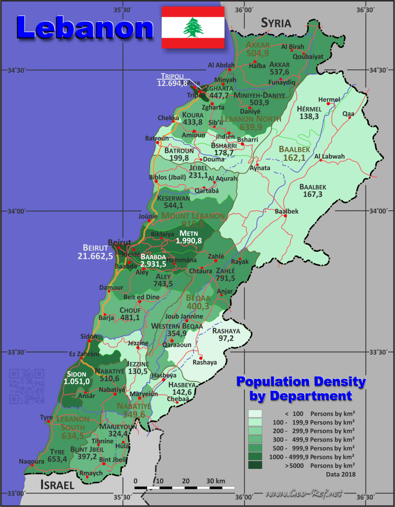
Country map - Administrative structure - Population density of Lebanon
Lebanon map - Click the map to get map as PDF file.
Other language versions are easy to generate, the descriptions are in own layers
Conditions for thematic maps with your own data and logotype
Delivery as printable file by e-mail or plot by post office
|
|---|
| Layers | |
| Provinces: | yes |
| Streets: | yes |
| Infrastructure: | yes |
| Rivers: | yes |
|
| Size | Till A2 |
| Delivery time | 7 working days | | Price |
| 1 bis 3 | 70 € | | > 3 | On request |
|
 |
All information published herein is free usable quoting the source,
including the maps, if they are not modified
|
|---|
Statistical data - Population density according to the administrative structure
The population data of the table below is form 2018, last available data.
The ources are very controversial, also the same governmental statistic service is not so helpful. The population and area data is not coherent with the sum of the district data.
Click on the column header brings the table in order of the column header.
The default order is the governorate name.
| Governorate |
ISO
3166-2 |
Capital |
Area
(km²) |
Population |
Density
(pers/km²) |
| Total |
|
|
10 200 |
5 416 225 |
531,0 |
|---|
| Last update: 05.06.2025 - 00:37:40 |
|---|
| Akkar |
LB-AK |
Halba |
788 |
423 596 |
537,6 |
| Baalbek |
LB-BH |
Baalbek |
2 825 |
457 932 |
162,1 |
| Beirut |
LB-BA |
Beirut |
20 |
433 249 |
21 662,5 |
| Beqaa |
LB-BI |
Zahle |
1 335 |
534 342 |
400,3 |
| Lebanon-North |
LB-AS |
Tripoli |
1 236 |
790 951 |
639,9 |
| Lebanon-South |
LB-JA |
Sidon |
930 |
590 078 |
634,5 |
| Mount-Lebanon |
LB-JL |
Baabda |
1 968 |
1 802 238 |
915,8 |
| Nabatiye |
LB-NA |
Nabatiye |
1 098 |
383 839 |
349,6 |
The following table is organized by districts, in which the governorates are divided.
| District |
ISO
3166-2 |
Governorate |
Capital
| Area
(km²) |
Population |
Density
(pers/km²) |
| Total |
|
|
|
10 200 |
5 416 225 |
531,0 |
|---|
| Last update: 05.06.2025 - 00:37:40 |
|---|
| Akkar |
AK-AK |
Akkar |
Halba |
788 |
423 596 |
537,6 |
| Aley |
JL-AL |
Mount-Lebanon |
Aley |
264 |
196 282 |
743,5 |
| Baabda |
JL-BD |
Mount-Lebanon |
Baabda |
194 |
568 714 |
2 931,5 |
| Baalbek |
BH-BB |
Baalbek |
Baalbek |
2 319 |
387 935 |
167,3 |
| Batroun |
AS-BT |
Lebanon-North |
Batroun |
287 |
57 339 |
199,8 |
| Beirut |
BA-BA |
Beirut |
Beirut |
20 |
433 249 |
21 662,5 |
| Bint Jbeil |
NA-BJ |
Nabatiye |
Bint Jbeil |
264 |
104 862 |
397,2 |
| Bsharri |
AS-BC |
Lebanon-North |
Bsharri |
158 |
28 231 |
178,7 |
| Chouf |
JL-CH |
Mount-Lebanon |
Beiteddine |
481 |
231 427 |
481,1 |
| Hasbaya |
NA-HA |
Nabatiye |
Hasbaya |
265 |
37 784 |
142,6 |
| Hermel |
BH-HE |
Baalbek |
Hermel |
506 |
69 997 |
138,3 |
| Jbeil |
JL-JB |
Mount-Lebanon |
Byblos |
430 |
99 388 |
231,1 |
| Jezzine |
JA-JE |
Liban-South |
Jezzine |
242 |
31 575 |
130,5 |
| Keserwan |
JL-KE |
Mount-Lebanon |
Jounieh |
336 |
182 834 |
544,1 |
| Koura |
AS-KO |
Lebanon-North |
Amioun |
173 |
75 056 |
433,8 |
| Marjeyoun |
NA-MJ |
Nabatiye |
Marjeyoun |
265 |
85 960 |
324,4 |
| Metn |
JL-MT |
Mount-Lebanon |
Jdeideh |
263 |
523 593 |
1 990,8 |
| Miniyeh-Danniyeh |
AS-MD |
Lebanon-North |
Miniyeh |
409 |
206 075 |
503,9 |
| Nabatieh |
NA-NA |
Nabatiye |
Nabatieh |
304 |
155 233 |
510,6 |
| Rashaya |
BI-RA |
Beqaa |
Rashaya |
485 |
47 122 |
97,2 |
| Sidon |
JA-SA |
Liban-South |
Sidon |
274 |
287 987 |
1 051,0 |
| Tripoli |
AS-TR |
Lebanon-North |
Tripoli |
27 |
342 760 |
12 694,8 |
| Tyre |
JA-SU |
Liban-South |
Tyre |
414 |
270 516 |
653,4 |
| Western Beqaa |
BI-BW |
Beqaa |
Joub Jannine |
425 |
150 838 |
354,9 |
| Zahlé |
BI-ZA |
Beqaa |
Zahlé |
425 |
336 382 |
791,5 |
| Zgharta |
AS-ZG |
Lebanon-North |
Zgharta |
182 |
81 490 |
447,7 |
Existing thematic maps
|
External links change quickly - If you get a link error - Please inform us!
 |
Membership in international organisations and treaties
Expand list
Political Alliances
Regional Unions
Military alliances/Arms control
Law enforcement
Business Alliances
Financial
Free Trade Area, Internal Market
Technical alliances
Transport
Cientific
Humanitarian Unions
Cultural Unions
|
|
If you have suggestions to include other information or you find missed links, please inform us!
Click here ... |
International Border disputes
Expand list
Land boundaries
Maritime boundaries
See also neighboring states
|
| |


