Republic of Korea
| Capital |
Currency | Government system |
|---|
| Seoul |
Won (KRW) |
Semi-presidential system |
| Official language | Region |
Population |
|---|
| Korean |
Far East |
Census 2020
51 829 136 |
Country map - Administrative structure - Population density of Korea South
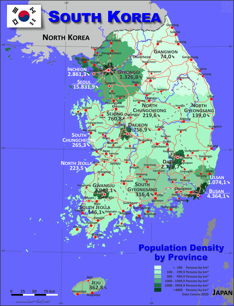
Korea South map - Click the map to get map as PDF file.
Other language versions are easy to generate, the descriptions are in own layers
Conditions for thematic maps with your own data and logotype
Delivery as printable file by e-mail or plot by post office
|
|---|
| Layers | |
| Provinces: | yes |
| Streets: | yes |
| Infrastructure: | yes |
| Rivers: | yes |
|
| Size | Till A2 |
| Delivery time | 7 working days | | Price |
| 1 bis 3 | 85 € | | > 3 | On request |
|
 |
All information published herein is free usable quoting the source,
including the maps, if they are not modified
|
|---|
Statistical data - Population density according to the administrative structure
The population data of the table below is census data from 2020, last available data.
Click on the column header brings the table in order of the column header.
The default order is the province name.
| Province |
ISO
3166-2 |
Type |
Capital |
Area
(km²) |
Population |
Density
(pers/km²) |
| Total |
|
|
|
103 965,8 |
51 829 136 |
36 397,3 |
|---|
| Last update: 17.01.2023 - 22:59:25 |
|---|
| Busan |
KR-26 |
Metropolitan city |
Busan |
767,4 |
3 349 016 |
4 364,1 |
| Daegu |
KR-27 |
Metropolitan city |
Daegu |
884,1 |
2 410 700 |
2 726,7 |
| Daejeon |
KR-30 |
Metropolitan city |
Daejeon |
539,9 |
1 488 435 |
2 756,9 |
| Gangwon |
KR-42 |
Province |
Chuncheon |
20 569,0 |
1 521 763 |
74 |
| Gwangju |
KR-29 |
Metropolitan city |
Gwangju |
501,2 |
1 477 573 |
2 948,1 |
| Gyeonggi |
KR-41 |
Province |
Suwon |
10 184,0 |
13 511 676 |
1 326,8 |
| Incheon |
KR-28 |
Metropolitan city |
Incheon |
1 029,4 |
2 945 454 |
2 861,3 |
| Jeju |
KR-49 |
Special Autonom Province |
Jeju City |
1 849,0 |
670 858 |
362,8 |
| North Chungcheong |
KR-43 |
Province |
Cheongju |
7 433,0 |
1 632 088 |
219,6 |
| North Gyeongsang |
KR-47 |
Province |
Daegu |
19 030,0 |
2 644 757 |
139 |
| North Jeolla |
KR-45 |
Province |
Jeonju |
8 067,0 |
1 802 766 |
223,5 |
| Sejong |
KR-50 |
Autonomous city |
Sejong |
465,2 |
353 933 |
760,8 |
| Seoul |
KR-11 |
Special city |
Seoul |
605,5 |
9 586 195 |
15 831,9 |
| South Chungcheong |
KR-44 |
Province |
Hongseong |
8 204,0 |
2 176 636 |
265,3 |
| South Gyeongsang |
KR-48 |
Province |
Changwon |
10 533,0 |
3 333 056 |
316,4 |
| South Jeolla |
KR-46 |
Province |
Muan |
12 247,0 |
1 788 807 |
146,1 |
| Ulsan |
KR-31 |
Metropolitan city |
Ulsan |
1 057,1 |
1 135 423 |
1 074,1 |
Existing thematic maps
|
External links change quickly - If you get a link error - Please inform us!
 |
Membership in international organisations and treaties
Expand list
Political Alliances
Regional Unions
Military alliances/Arms control
Law enforcement
Business Alliances
Fishery
Financial
Free Trade Area, Internal Market
Technical alliances
Environment
Transport
Cientific
Humanitarian Unions
Cultural Unions
|
|
If you have suggestions to include other information or you find missed links, please inform us!
Click here ... |
International Border disputes
Expand list
See also neighboring states
|
| |


