Senkaku / Diaoyu Islands
| Capital |
Currency | Government system |
|---|
| none |
Differentes |
Different claims |
| Official language | Region |
Population |
|---|
Chinese
Japanese |
Far East |
0 |
Country map - Administrative structure - Population density of Senkaku Islands
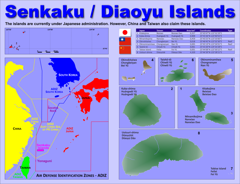
Senkaku Islands map - Click the map to get map as PDF file.
Other language versions are easy to generate, the descriptions are in own layers
Conditions for thematic maps with your own data and logotype
Delivery as printable file by e-mail or plot by post office
|
|---|
| Layers |
|
| Provinces: | yes |
| Streets: | no |
| Infrastructure: | no |
| Rivers: | yes |
|
| Size | Till A2 |
| Delivery time | 7 working days | | Price |
| 1 bis 3 | 60 € | | > 3 | On request |
|
 |
All information published herein is free usable quoting the source,
including the maps, if they are not modified
|
|---|
Statistical data - Population density according to the administrative structure
The islands are not populated. (2021)
The
order of the islands corresponds to the graph above.
| Island name in |
Area
(km²) |
Coordinates |
|---|
| Japan |
Taiwan |
China |
| |
|
|
6,100 |
|
|---|
| Updated: 08.09.2023 - 16:30:34 |
| Kitakojima |
Beixiao |
Beixiao Dao |
0,327 |
25°43'47"N 123°32'29"E |
| Kuba-shima |
Huángwei Yu |
Huángwei Yu |
0,909 |
25°55'26"N 123°40'55"E |
| Minamikojima |
Nanxiao |
Nanxiao Dao |
0,459 |
25°43'25"N 123°33'00"E |
| Okinokitaiwa |
Chongbeiyan |
Bei Yu |
0,018 |
25°46'45"N 123°32'30"E |
| Okinominamiiwa |
Chongnanyan |
Nan Yu |
0,005 |
25°45'19"N 123°34'01"E |
| Taishō-tō |
Chìwei Yu |
Chìwei Yu |
0,061 |
25°55'20"N 124°33'28"E |
| Tobise Island |
Feilai |
Fei Yu |
0,001 |
25°44'08"N 123°30'22"E |
| Uotsuri-shima |
Diàoyútái |
Diàoyú Dao |
4,320 |
25°44'39"N 123°28'21"E |
Existing thematic maps
|
External links change quickly - If you get a link error - Please inform us!
 |
See also neighboring states
|


