Republic of Guinea
| Capital |
Currency | Government system |
|---|
| Conakry |
Guinean Franc (GNF) |
Presidential system |
| Official language | Region |
Population |
|---|
| French |
Africa |
Census 2014
10 523 261 |
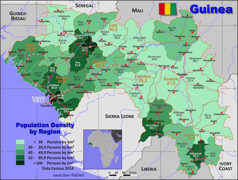
Country map - Administrative structure - Population density of Guinea
Guinea map - Click the map to get map as PDF file.
Other language versions are easy to generate, the descriptions are in own layers
Conditions for thematic maps with your own data and logotype
Delivery as printable file by e-mail or plot by post office
|
|---|
| Layers | |
| Provinces: | yes |
| Streets: | yes |
| Infrastructure: | yes |
| Rivers: | yes |
|
| Size | Till A2 |
| Delivery time | 7 working days | | Price |
| 1 bis 3 | 75 € | | > 3 | On request |
|
 |
All information published herein is free usable quoting the source,
including the maps, if they are not modified
|
|---|
Statistical data - Population density according to the administrative structure
The population data of the table below is census data from 2014, last available data.
Click on the column header brings the table in order of the column header.
The default order is the prefectue name.
| Prefectue |
ISO
3166-2 |
Region |
Capital |
Area
(km²) |
Population |
Density
(pers/km²) |
| Total |
|
|
|
246 021 |
10 523 261 |
42,8 |
|---|
| Last update: 17.03.2025 - 20:19:49 |
|---|
| Beyla |
GN-BE |
Nzérékoré |
Beyla |
12 608 |
326 082 |
25,9 |
| Boffa |
GN-BF |
Boké |
Boffa |
5 225 |
212 583 |
40,7 |
| Boké |
GN-BK |
Boké |
Boké |
10 693 |
450 278 |
42,1 |
| Conakry |
GN-C |
Conakry |
Conakry |
405 |
1 660 973 |
4 101,2 |
| Coyah |
GN-CO |
Kindia |
Coyah |
1 148 |
263 861 |
229,8 |
| Dabola |
GN-DB |
Faranah |
Dabola |
5 207 |
181 137 |
34,8 |
| Dalaba |
GN-DL |
Mamou |
Dalaba |
3 115 |
133 677 |
42,9 |
| Dinguiraye |
GN-DI |
Faranah |
Dinguiraye |
11 544 |
196 469 |
17,0 |
| Dubréka |
GN-DU |
Kindia |
Dubréka |
3 981 |
330 548 |
83,0 |
| Faranah |
GN-FA |
Faranah |
Faranah |
12 960 |
280 170 |
21,6 |
| Forécariah |
GN-FO |
Kindia |
Forécariah |
4 399 |
242 942 |
55,2 |
| Fria |
GN-FR |
Boké |
Fria |
1 588 |
96 700 |
60,9 |
| Gaoual |
GN-GA |
Boké |
Gaoual |
11 252 |
193 612 |
17,2 |
| Guéckédou |
GN-GU |
Nzérékoré |
Guéckédou |
4 242 |
290 611 |
68,5 |
| Kankan |
GN-KA |
Kankan |
Kankan |
17 422 |
473 359 |
27,2 |
| Kérouane |
GN-KE |
Kankan |
Kérouane |
9 430 |
207 547 |
22,0 |
| Kindia |
GN-KD |
Kindia |
Kindia |
8 904 |
439 614 |
49,4 |
| Kissidougou |
GN-KS |
Faranah |
Kissidougou |
6 225 |
283 778 |
45,6 |
| Koubia |
GN-KB |
Labé |
Koubia |
3 564 |
100 170 |
28,1 |
| Koundara |
GN-KN |
Boké |
Koundara |
5 297 |
129 974 |
24,5 |
| Kouroussa |
GN-KO |
Kankan |
Kouroussa |
15 866 |
268 630 |
16,9 |
| Labé |
GN-LA |
Labé |
Labé |
2 120 |
318 938 |
150,4 |
| Lélouma |
GN-LE |
Labé |
Lélouma |
2 733 |
163 069 |
59,7 |
| Lola |
GN-LO |
Nzérékoré |
Lola |
4 569 |
171 561 |
37,5 |
| Macenta |
GN-MC |
Nzérékoré |
Macenta |
8 059 |
278 456 |
34,6 |
| Mali |
GN-ML |
Labé |
Mali |
8 400 |
288 001 |
34,3 |
| Mamou |
GN-MM |
Mamou |
Mamou |
10 254 |
318 981 |
31,1 |
| Mandiana |
GN-MD |
Kankan |
Mandiana |
11 701 |
335 999 |
28,7 |
| Nzérékoré |
GN-NZ |
Nzérékoré |
Nzérékoré |
3 994 |
396 949 |
99,4 |
| Pita |
GN-PI |
Mamou |
Pita |
4 524 |
278 530 |
61,6 |
| Siguiri |
GN-SI |
Kankan |
Siguiri |
17 760 |
687 002 |
38,7 |
| Télimélé |
GN-TE |
Kindia |
Télimélé |
7 574 |
284 409 |
37,6 |
| Tougué |
GN-TO |
Labé |
Tougué |
6 026 |
124 280 |
20,6 |
| Yomou |
GN-YO |
Nzérékoré |
Yomou |
3 232 |
114 371 |
35,4 |
The Prefectures are divided into Sub-Prefectures, the same are illustrated in the next table.
| Sub-Prefecture |
HASC |
Prefecture |
Capital
| Area
(km²) |
Population |
Density
(pers/km²) |
| Total |
|
|
|
246 021 |
10 523 261 |
42,8 |
|---|
| Last update: 17.03.2025 - 20:19:50 |
|---|
| Alassoya |
FO.AL |
Forécariah |
Alassoya |
570 |
14 817 |
26,0 |
| Albadariah |
KS.AL |
Kissidougou |
Albadariah |
708 |
16 864 |
23,8 |
| Arfamoussaya |
DB.AR |
Dabola |
Arfamoussaya |
573 |
16 523 |
28,8 |
| Babila |
KO.BB |
Kouroussa |
Babila |
131 |
15 795 |
120,6 |
| Badi |
DU.BA |
Dubréka |
Badi |
299 |
10 651 |
35,6 |
| Baguinet |
FR.BT |
Fria |
Baguinet |
452 |
13 843 |
30,6 |
| Balaki |
ML.BA |
Mali |
Balaki |
2 727 |
11 561 |
4,2 |
| Balandougou |
KA.BA |
Kankan |
Balandougou |
924 |
26 371 |
28,5 |
| Balandougouba |
MD.BA |
Mandiana |
Balandougouba |
572 |
28 686 |
50,2 |
| Balato |
KO.BL |
Kouroussa |
Balato |
246 |
16 403 |
66,7 |
| Balaya |
LE.BA |
Lélouma |
Balaya |
253 |
10 212 |
40,4 |
| Balizia |
MC.BA |
Macenta |
Balizia |
407 |
14 692 |
36,1 |
| Banama |
KS.BN |
Kissidougou |
Banama |
346 |
8 842 |
25,6 |
| Banankoro |
KE.BA |
Kérouane |
Banankoro |
1 089 |
66 597 |
61,2 |
| Banfélé |
KO.BN |
Kouroussa |
Banfélé |
2 101 |
24 650 |
11,7 |
| Bangouyah |
KD.BA |
Kindia |
Bangouyah |
1 133 |
52 923 |
46,7 |
| Banguingny |
FR.BY |
Fria |
Banguingny |
399 |
8 662 |
21,7 |
| Banian |
FA.BA |
Faranah |
Banian |
1 957 |
36 634 |
18,7 |
| Banié |
YO.BA |
Yomou |
Banié |
185 |
11 818 |
63,9 |
| Banko |
DB.BA |
Dabola |
Banko |
767 |
23 610 |
30,8 |
| Bankon |
SI.BA |
Siguiri |
Bankon |
330 |
18 263 |
55,3 |
| Banora |
DI.BA |
Dinguiraye |
Banora |
3 201 |
33 823 |
10,6 |
| Bantignel |
PI.BA |
Pita |
Bantignel |
264 |
14 032 |
53,2 |
| Bardou |
KS.BR |
Kissidougou |
Bardou |
379 |
9 715 |
25,6 |
| Baro |
KO.BR |
Kouroussa |
Baro |
257 |
15 514 |
60,4 |
| Bate-Nafadji |
KA.BN |
Kankan |
Bate-Nafadji |
1 304 |
48 278 |
37,0 |
| Beindou |
FA.BE |
Faranah |
Beindou |
1 849 |
16 630 |
9,0 |
| Beindou |
KS.BE |
Kissidougou |
Beindou |
407 |
14 750 |
36,2 |
| Benty |
FO.BE |
Forécariah |
Benty |
374 |
24 159 |
64,6 |
| Beyla-Centre |
BE.BE |
Beyla |
Beyla-Centre |
427 |
32 212 |
75,4 |
| Bheeta |
YO.BH |
Yomou |
Bheeta |
245 |
10 560 |
43,1 |
| Bignamou |
YO.BI |
Yomou |
Bignamou |
259 |
14 859 |
57,4 |
| Binikala |
MC.BI |
Macenta |
Binikala |
806 |
17 687 |
21,9 |
| Bintimodiya |
BK.BI |
Boké |
Bintimodiya |
335 |
25 901 |
77,3 |
| Bissikrima |
DB.BI |
Dabola |
Bissikrima |
619 |
28 638 |
46,3 |
| Bodié |
DL.BO |
Dalaba |
Bodié |
365 |
8 967 |
24,6 |
| Boffa-Centre |
BF.BF |
Boffa |
Boffa-Centre |
674 |
27 130 |
40,3 |
| Bofossou |
MC.BO |
Macenta |
Bofossou |
282 |
13 803 |
48,9 |
| Boké-Centre |
BK.BK |
Boké |
Boké-Centre |
237 |
61 758 |
260,6 |
| Bolodou |
GU.BO |
Guéckédou |
Bolodou |
526 |
13 643 |
25,9 |
| Boola |
BE.BO |
Beyla |
Boola |
1 041 |
22 542 |
21,7 |
| Bossou |
LO.BO |
Lola |
Bossou |
212 |
9 883 |
46,6 |
| Boula |
KA.BO |
Kankan |
Boula |
3 512 |
15 699 |
4,5 |
| Bouliwel |
MM.BO |
Mamou |
Bouliwel |
540 |
20 881 |
38,7 |
| Bounouma |
NZ.BO |
Nzérékoré |
Bounouma |
500 |
21 988 |
44,0 |
| Bourouwal |
TE.BO |
Télimélé |
Bourouwal |
263 |
25 410 |
96,6 |
| Bourouwal-Tappé |
PI.BT |
Pita |
Bourouwal-Tappé |
179 |
9 740 |
54,4 |
| Bowé |
YO.BO |
Yomou |
Bowé |
494 |
14 294 |
28,9 |
| Cisséla |
KO.CI |
Kouroussa |
Cisséla |
1 161 |
41 740 |
36,0 |
| Colia |
BF.CO |
Boffa |
Colia |
1 717 |
35 737 |
20,8 |
| Coyah-Centre |
CO.CO |
Coyah |
Coyah-Centre |
24 |
49 738 |
2 072,4 |
| Dabiss |
BK.DA |
Boké |
Dabiss |
2 596 |
29 897 |
11,5 |
| Dabola-Centre |
DB.DB |
Dabola |
Dabola-Centre |
226 |
38 464 |
170,2 |
| Dalaba-Centre |
DL.DL |
Dalaba |
Dalaba-Centre |
204 |
24 193 |
118,6 |
| Dalein |
LA.DL |
Labé |
Dalein |
320 |
17 733 |
55,4 |
| Damankanyah |
KD.DA |
Kindia |
Damankanyah |
184 |
25 897 |
140,7 |
| Damaro |
KE.DA |
Kérouane |
Damaro |
392 |
27 395 |
69,9 |
| Daralabe |
LA.DB |
Labé |
Daralabe |
96 |
9 087 |
94,7 |
| Daramagnaky |
TE.DA |
Télimélé |
Daramagnaky |
821 |
33 229 |
40,5 |
| Daro |
MC.DA |
Macenta |
Daro |
291 |
14 545 |
50,0 |
| Dialakoro |
MD.DI |
Mandiana |
Dialakoro |
1 379 |
63 051 |
45,7 |
| Dialakoro |
DI.DL |
Dinguiraye |
Dialakoro |
278 |
14 882 |
53,5 |
| Diara-Guerela |
BE.DR |
Beyla |
Diara-Guerela |
1 111 |
11 340 |
10,2 |
| Diari |
LA.DR |
Labé |
Diari |
197 |
14 705 |
74,6 |
| Diassadou |
BE.DS |
Beyla |
Diassadou |
608 |
16 922 |
27,8 |
| Diatiféré |
DI.DT |
Dinguiraye |
Diatiféré |
1 466 |
33 658 |
23,0 |
| Diécké |
YO.DI |
Yomou |
Diécké |
750 |
31 799 |
42,4 |
| Dinguiraye-Centre |
DI.DI |
Dinguiraye |
Dinguiraye-Centre |
1 922 |
47 207 |
24,6 |
| Dionfo |
LA.DF |
Labé |
Dionfo |
94 |
12 633 |
134,4 |
| Ditinn |
DL.DI |
Dalaba |
Ditinn |
289 |
13 121 |
45,4 |
| Dixinn |
CK.DI |
Conakry |
Dixinn |
7 |
135 788 |
19 398,3 |
| Djountou |
LE.DJ |
Lélouma |
Djountou |
149 |
17 928 |
120,3 |
| Dogomet |
DB.DO |
Dabola |
Dogomet |
595 |
27 748 |
46,6 |
| Doko |
SI.DO |
Siguiri |
Doko |
1 620 |
86 782 |
53,6 |
| Donghol-Sigon |
ML.DS |
Mali |
Donghol-Sigon |
412 |
25 222 |
61,2 |
| Dongol-Touma |
PI.DT |
Pita |
Dongol-Touma |
362 |
23 569 |
65,1 |
| Douako |
KO.DK |
Kouroussa |
Douako |
2 872 |
23 416 |
8,2 |
| Dougountouny |
ML.DO |
Mali |
Dougountouny |
296 |
36 496 |
123,3 |
| Dounet |
MM.DO |
Mamou |
Dounet |
404 |
30 534 |
75,6 |
| Douprou |
BF.DO |
Boffa |
Douprou |
274 |
21 405 |
78,1 |
| Doura |
KO.DR |
Kouroussa |
Doura |
720 |
18 664 |
25,9 |
| Dubréka-Centre |
DU.DU |
Dubréka |
Dubréka-Centre |
155 |
170 388 |
1 099,3 |
| Fafaya |
KB.FA |
Koubia |
Fafaya |
664 |
20 202 |
30,4 |
| Falessade |
DU.FA |
Dubréka |
Falessade |
430 |
11 186 |
26,0 |
| Fangamadou |
GU.FA |
Guéckédou |
Fangamadou |
376 |
24 516 |
65,2 |
| Faralako |
MD.FA |
Mandiana |
Faralako |
1 279 |
23 954 |
18,7 |
| Faranah-Centre |
FA.FA |
Faranah |
Faranah-Centre |
400 |
77 918 |
194,8 |
| Farmoriah |
FO.FA |
Forécariah |
Farmoriah |
733 |
33 057 |
45,1 |
| Fassankoni |
MC.FA |
Macenta |
Fassankoni |
430 |
13 892 |
32,3 |
| Fatako |
TO.FA |
Tougué |
Fatako |
207 |
9 734 |
47,0 |
| Fello-Koundoua |
TO.FK |
Tougué |
Fello-Koundoua |
1 101 |
7 926 |
7,2 |
| Fermesadou-Pombo |
KS.FP |
Kissidougou |
Fermesadou-Pombo |
422 |
19 550 |
46,3 |
| Firawa |
KS.FI |
Kissidougou |
Firawa |
365 |
11 355 |
31,1 |
| Forécariah-Centre |
FO.FO |
Forécariah |
Forécariah-Centre |
10 |
20 275 |
2 027,5 |
| Fouala |
BE.FO |
Beyla |
Fouala |
335 |
16 619 |
49,6 |
| Fougou |
ML.FO |
Mali |
Fougou |
216 |
20 132 |
93,2 |
| Foulamory |
GA.FO |
Gaoual |
Foulamory |
1 510 |
10 174 |
6,7 |
| Foumbadou |
LO.FO |
Lola |
Foumbadou |
1 072 |
19 081 |
17,8 |
| Franwalia |
SI.FR |
Siguiri |
Franwalia |
849 |
29 272 |
34,5 |
| Fria-Centre |
FR.FR |
Fria |
Fria-Centre |
448 |
61 582 |
137,5 |
| Friguiagbé |
KD.FR |
Kindia |
Friguiagbé |
421 |
34 062 |
80,9 |
| Gadha-Woundou |
KB.GW |
Koubia |
Gadha-Woundou |
1 179 |
6 964 |
5,9 |
| Gagnakali |
DI.GA |
Dinguiraye |
Gagnakali |
2 652 |
12 659 |
4,8 |
| Gama |
LO.GB |
Lola |
Gama |
490 |
16 450 |
33,6 |
| Gaoual-Centre |
GA.GA |
Gaoual |
Gaoual-Centre |
139 |
20 570 |
148,0 |
| Garambé |
LA.GA |
Labé |
Garambé |
72 |
9 418 |
130,8 |
| Gayah |
ML.GA |
Mali |
Gayah |
239 |
13 163 |
55,1 |
| Gbackédou |
BE.GK |
Beyla |
Gbackédou |
395 |
22 474 |
56,9 |
| Gbangbadou |
KS.GB |
Kissidougou |
Gbangbadou |
276 |
13 867 |
50,2 |
| Gbérédou-Baranama |
KA.GB |
Kankan |
Gbérédou-Baranama |
863 |
17 770 |
20,6 |
| Gbéssoba |
BE.GS |
Beyla |
Gbéssoba |
2 197 |
35 372 |
16,1 |
| Gnaléah |
FA.GN |
Faranah |
Gnaléah |
1 052 |
14 642 |
13,9 |
| Gongore |
PI.GO |
Pita |
Gongore |
482 |
16 876 |
35,0 |
| Gongoret |
MM.GO |
Mamou |
Gongoret |
283 |
8 731 |
30,9 |
| Gouécké |
NZ.GO |
Nzérékoré |
Gouécké |
134 |
19 177 |
143,1 |
| Gougoudjé |
TE.GO |
Télimélé |
Gougoudjé |
178 |
10 790 |
60,6 |
| Guéassou |
LO.GU |
Lola |
Guéassou |
922 |
20 846 |
22,6 |
| Guéckédou-Centre |
GU.GU |
Guéckédou |
Guéckédou-Centre |
126 |
66 761 |
529,8 |
| Guéndembou |
GU.GD |
Guéckédou |
Guéndembou |
714 |
31 405 |
44,0 |
| Guingan |
KN.GU |
Koundara |
Guingan |
1 224 |
14 293 |
11,7 |
| Hafia |
LA.HA |
Labé |
Hafia |
194 |
14 497 |
74,7 |
| Herémakonon |
FA.HE |
Faranah |
Herémakonon |
1 143 |
13 078 |
11,4 |
| Hérico |
LE.HE |
Lélouma |
Hérico |
397 |
18 092 |
45,6 |
| Hidayatou |
ML.HI |
Mali |
Hidayatou |
377 |
12 190 |
32,3 |
| Kaala |
DL.KL |
Dalaba |
Kaala |
101 |
7 024 |
69,5 |
| Kaalan |
LA.KA |
Labé |
Kaalan |
115 |
10 213 |
88,8 |
| Kaback |
FO.KB |
Forécariah |
Kaback |
139 |
20 090 |
144,5 |
| Kakony |
GA.KA |
Gaoual |
Kakony |
1 595 |
32 632 |
20,5 |
| Kakossa |
FO.KK |
Forécariah |
Kakossa |
172 |
9 389 |
54,6 |
| Kalinko |
DI.KA |
Dinguiraye |
Kalinko |
900 |
31 970 |
35,5 |
| Kallia |
FO.KL |
Forécariah |
Kallia |
548 |
19 272 |
35,2 |
| Kaloum |
CK.KA |
Conakry |
Kaloum |
5 |
62 507 |
12 501,4 |
| Kamaby |
KN.KA |
Koundara |
Kamaby |
1 052 |
16 129 |
15,3 |
| Kamsar |
BK.KM |
Boké |
Kamsar |
516 |
113 350 |
219,7 |
| Kanfarandé |
BK.KF |
Boké |
Kanfarandé |
1 349 |
29 407 |
21,8 |
| Kankalabé |
DL.KN |
Dalaba |
Kankalabé |
382 |
15 955 |
41,8 |
| Kankama |
DB.KA |
Dabola |
Kankama |
416 |
13 297 |
32,0 |
| Kankan-Centre |
KA.KA |
Kankan |
Kankan-Centre |
155 |
194 671 |
1 255,9 |
| Kansangui |
TO.KA |
Tougué |
Kansangui |
453 |
8 703 |
19,2 |
| Kantoumania |
MD.KA |
Mandiana |
Kantoumania |
1 018 |
11 711 |
11,5 |
| Karala |
BE.KA |
Beyla |
Karala |
1 665 |
10 815 |
6,5 |
| Karifamoriyah |
KA.KM |
Kankan |
Karifamoriyah |
851 |
24 785 |
29,1 |
| Kassadou |
GU.KA |
Guéckédou |
Kassadou |
771 |
19 881 |
25,8 |
| Kébali |
DL.KE |
Dalaba |
Kébali |
209 |
11 540 |
55,2 |
| Kégnéko |
MM.KE |
Mamou |
Kégnéko |
1 285 |
19 134 |
14,9 |
| Kérouane-Centre |
KE.KE |
Kérouane |
Kérouane-Centre |
870 |
36 314 |
41,7 |
| Khorira |
DU.KH |
Dubréka |
Khorira |
1 157 |
25 505 |
22,0 |
| Kindia-Centre |
KD.KI |
Kindia |
Kindia-Centre |
907 |
170 557 |
188,0 |
| Kindoyé |
DB.KI |
Dabola |
Kindoyé |
743 |
6 382 |
8,6 |
| Kiniébakoura |
SI.KB |
Siguiri |
Kiniébakoura |
495 |
28 684 |
57,9 |
| Kiniéran |
MD.KI |
Mandiana |
Kiniéran |
406 |
37 877 |
93,3 |
| Kiniéro |
KO.KI |
Kouroussa |
Kiniéro |
946 |
22 478 |
23,8 |
| Kintinian |
SI.KT |
Siguiri |
Kintinian |
1 728 |
124 847 |
72,2 |
| Kissidougou-Centre |
KS.KS |
Kissidougou |
Kissidougou-Centre |
202 |
103 335 |
511,6 |
| Koba |
DL.KO |
Télimélé |
Koba |
747 |
9 439 |
12,6 |
| Koba |
TE.KB |
Dalaba |
Koba |
489 |
16 876 |
34,5 |
| Koba-Tatema |
BF.KT |
Boffa |
Koba-Tatema |
558 |
51 111 |
91,6 |
| Kobéla |
NZ.KB |
Nzérékoré |
Kobéla |
325 |
15 198 |
46,8 |
| Kobikoro |
FA.KO |
Faranah |
Kobikoro |
629 |
13 909 |
22,1 |
| Koin |
TO.KI |
Tougué |
Koin |
219 |
13 969 |
63,8 |
| Kokota |
LO.KO |
Lola |
Kokota |
212 |
14 610 |
68,9 |
| Kolaboui |
BK.KO |
Boké |
Kolaboui |
349 |
57 442 |
164,6 |
| Kolangui |
TO.KG |
Tougué |
Kolangui |
392 |
7 287 |
18,6 |
| Kolenté |
KD.KO |
Kindia |
Kolenté |
878 |
31 312 |
35,7 |
| Kollet |
TO.KL |
Tougué |
Kollet |
1 423 |
17 393 |
12,2 |
| Kollet |
TE.KL |
Télimélé |
Kollet |
498 |
21 191 |
42,6 |
| Komodou |
KE.KM |
Kérouane |
Komodou |
1 466 |
21 584 |
14,7 |
| Komola-Koura |
KO.KK |
Kouroussa |
Komola-Koura |
3 174 |
14 038 |
4,4 |
| Konah |
TO.KN |
Tougué |
Konah |
333 |
13 680 |
41,1 |
| Kondianakoro |
MD.KK |
Mandiana |
Kondianakoro |
392 |
31 503 |
80,4 |
| Konindou |
DB.KO |
Dabola |
Konindou |
474 |
10 013 |
21,1 |
| Konkouré |
MM.KO |
Mamou |
Konkouré |
479 |
13 039 |
27,2 |
| Konsotamy |
TE.KS |
Télimélé |
Konsotamy |
879 |
12 979 |
14,8 |
| Korbé |
LE.KO |
Lélouma |
Korbé |
142 |
7 462 |
52,5 |
| Koropara |
NZ.KR |
Nzérékoré |
Koropara |
761 |
19 035 |
25,0 |
| Kouankan |
MC.KK |
Macenta |
Kouankan |
1 281 |
30 225 |
23,6 |
| Koubia-Centre |
KB.KB |
Koubia |
Koubia-Centre |
376 |
21 889 |
58,2 |
| Koulé |
NZ.KL |
Nzérékoré |
Koulé |
236 |
18 922 |
80,2 |
| Koumana |
KO.KM |
Kouroussa |
Koumana |
448 |
12 804 |
28,6 |
| Koumandou |
BE.KO |
Beyla |
Koumandou |
996 |
13 119 |
13,2 |
| Koumban |
KA.KO |
Kankan |
Koumban |
840 |
21 145 |
25,2 |
| Koumbia |
GA.KM |
Gaoual |
Koumbia |
3 643 |
46 419 |
12,7 |
| Koundara-Centre |
KN.KD |
Koundara |
Koundara-Centre |
80 |
27 296 |
341,2 |
| Koundian |
MD.KD |
Mandiana |
Koundian |
845 |
32 353 |
38,3 |
| Koundiatou |
KS.KO |
Kissidougou |
Koundiatou |
484 |
15 020 |
31,0 |
| Koundou |
GU.KO |
Guéckédou |
Koundou |
454 |
28 337 |
62,4 |
| Kounsankoro |
KE.KS |
Kérouane |
Kounsankoro |
943 |
6 913 |
7,3 |
| Kounsitel |
GA.KN |
Gaoual |
Kounsitel |
1 878 |
18 457 |
9,8 |
| Kouramangui |
LA.KO |
Labé |
Kouramangui |
181 |
14 498 |
80,1 |
| Kouratongo |
TO.KR |
Tougué |
Kouratongo |
891 |
11 232 |
12,6 |
| Kouriah |
CO.KO |
Coyah |
Kouriah |
487 |
10 009 |
20,6 |
| Kouroussa-Centre |
KO.KO |
Kouroussa |
Kouroussa-Centre |
685 |
39 412 |
57,5 |
| Koyamah |
MC.KY |
Macenta |
Koyamah |
447 |
25 012 |
56,0 |
| Labé-Centre |
LA.LA |
Labé |
Labé-Centre |
76 |
141 730 |
1 864,9 |
| Lafou |
LE.LA |
Lélouma |
Lafou |
203 |
20 184 |
99,4 |
| Lain (Laine) |
LO.LA |
Lola |
Lain (Laine) |
425 |
16 309 |
38,4 |
| Lansanya |
DI.LA |
Dinguiraye |
Lansanya |
471 |
9 106 |
19,3 |
| Lébékére |
ML.LE |
Mali |
Lébékére |
1 151 |
11 675 |
10,1 |
| Lélouma-Centre |
LE.LE |
Lélouma |
Lélouma-Centre |
70 |
14 491 |
207,0 |
| Ley-Miro |
PI.LM |
Pita |
Ley-Miro |
421 |
19 375 |
46,0 |
| Linko |
KE.LI |
Kérouane |
Linko |
1 545 |
11 583 |
7,5 |
| Linsan |
LE.LS |
Lélouma |
Linsan |
512 |
10 369 |
20,3 |
| Lisso |
BF.LI |
Boffa |
Lisso |
858 |
11 830 |
13,8 |
| Lola-Centre |
LO.LO |
Lola |
Lola-Centre |
360 |
47 995 |
133,3 |
| Macenta-Centre |
MC.MC |
Macenta |
Macenta-Centre |
110 |
65 755 |
597,8 |
| Maci |
PI.MA |
Pita |
Maci |
415 |
21 977 |
53,0 |
| Madina-Oula |
KD.MO |
Kindia |
Madina-Oula |
1 432 |
23 381 |
16,3 |
| Madina-Wora |
ML.MW |
Mali |
Madina-Wora |
693 |
30 283 |
43,7 |
| Mafara |
DL.MA |
Dalaba |
Mafara |
526 |
8 182 |
15,6 |
| Maférinya |
FO.MA |
Forécariah |
Maférinya |
524 |
43 730 |
83,5 |
| Malanta |
GA.MA |
Gaoual |
Malanta |
404 |
14 173 |
35,1 |
| Malapouyah |
BK.MA |
Boké |
Malapouyah |
579 |
10 271 |
17,7 |
| Maléa |
SI.MA |
Siguiri |
Maléa |
1 537 |
27 471 |
17,9 |
| Mali-Centre |
ML.ML |
Mali |
Mali-Centre |
494 |
39 808 |
80,6 |
| Mambia |
KD.MA |
Kindia |
Mambia |
808 |
26 500 |
32,8 |
| Mamou-Centre |
MM.MM |
Mamou |
Mamou-Centre |
176 |
83 008 |
471,6 |
| Mamouroudou |
KA.MA |
Kankan |
Mamouroudou |
1 547 |
14 696 |
9,5 |
| Manda |
LE.MA |
Lélouma |
Manda |
66 |
7 925 |
120,1 |
| Mandiana-Centre |
MD.MD |
Mandiana |
Mandiana-Centre |
573 |
22 719 |
39,6 |
| Manéah |
CO.MA |
Coyah |
Manéah |
60 |
167 531 |
2 792,2 |
| Manfran |
KS.MA |
Kissidougou |
Manfran |
869 |
13 971 |
16,1 |
| Mankountan |
BF.MA |
Boffa |
Mankountan |
318 |
17 148 |
53,9 |
| Maréla |
FA.MA |
Faranah |
Maréla |
667 |
32 646 |
48,9 |
| Matakaou |
KB.MA |
Koubia |
Matakaou |
401 |
16 515 |
41,2 |
| Matam |
CK.MM |
Conakry |
Matam |
7 |
143 255 |
20 465,0 |
| Matoto |
CK.MO |
Conakry |
Matoto |
211 |
666 640 |
3 159,4 |
| Missamana |
KA.MI |
Kankan |
Missamana |
1 170 |
17 962 |
15,4 |
| Missira |
TE.MI |
Koubia |
Missira |
355 |
11 159 |
31,4 |
| Missira |
KB.MI |
Télimélé |
Missira |
1 224 |
43 681 |
35,7 |
| Mitty |
DL.MI |
Dalaba |
Mitty |
338 |
13 737 |
40,6 |
| Molota |
KD.ML |
Kindia |
Molota |
468 |
12 109 |
25,9 |
| Mombéyah |
DL.MO |
Dalaba |
Mombéyah |
212 |
14 082 |
66,4 |
| Moribayah |
KA.MO |
Kankan |
Moribayah |
1 736 |
14 385 |
8,3 |
| Morodou |
MD.MO |
Mandiana |
Morodou |
859 |
28 431 |
33,1 |
| Moussadou |
BE.MO |
Beyla |
Moussadou |
682 |
15 638 |
22,9 |
| Moussaya |
FO.MO |
Forécariah |
Moussaya |
688 |
38 005 |
55,2 |
| Naboun |
SI.NA |
Siguiri |
Naboun |
1 675 |
25 348 |
15,1 |
| N`Déma |
DB.ND |
Dabola |
N`Déma |
794 |
16 462 |
20,7 |
| Niagassola |
SI.NG |
Siguiri |
Niagassola |
3 070 |
30 640 |
10,0 |
| Niandankoro |
SI.ND |
Siguiri |
Niandankoro |
745 |
23 855 |
32,0 |
| Niantania |
MD.NI |
Mandiana |
Niantania |
860 |
14 523 |
16,9 |
| Ninguélandé |
PI.NI |
Pita |
Ninguélandé |
323 |
25 868 |
80,1 |
| Nionsomoridou |
BE.NI |
Beyla |
Nionsomoridou |
816 |
15 627 |
19,2 |
| Nongoa |
GU.NO |
Guéckédou |
Nongoa |
119 |
14 959 |
125,7 |
| Norassoba |
SI.NO |
Siguiri |
Norassoba |
2 690 |
40 137 |
14,9 |
| Nounkounkan |
n.d. |
Siguiri |
Nounkounkan |
9 |
12 875 |
1 430,6 |
| Noussy |
LA.NO |
Labé |
Noussy |
210 |
13 797 |
65,7 |
| Nyagara |
MM.NY |
Mamou |
Nyagara |
431 |
12 319 |
28,6 |
| N`Zébéla |
MC.NZ |
Macenta |
N`Zébéla |
657 |
16 268 |
24,8 |
| Nzérékoré-Centre |
NZ.NZ |
Nzérékoré |
Nzérékoré-Centre |
92 |
195 330 |
2 123,2 |
| N`Zoo |
LO.NZ |
Lola |
N`Zoo |
538 |
15 057 |
28,0 |
| Ouassou |
DU.OU |
Dubréka |
Ouassou |
402 |
15 647 |
38,9 |
| Ouéndé-Kénéma |
GU.OK |
Guéckédou |
Ouéndé-Kénéma |
210 |
30 705 |
146,2 |
| Ouré-Kaba |
MM.OK |
Mamou |
Ouré-Kaba |
1 683 |
31 804 |
18,9 |
| Ourémai |
MC.OU |
Macenta |
Ourémai |
735 |
9 002 |
12,2 |
| Palé |
NZ.PA |
Nzérékoré |
Palé |
136 |
10 125 |
74,4 |
| Panziazou |
MC.PA |
Macenta |
Panziazou |
239 |
8 440 |
35,3 |
| Parawol |
LE.PA |
Lélouma |
Parawol |
271 |
14 561 |
53,7 |
| Passayah |
FA.PA |
Faranah |
Passayah |
2 968 |
19 862 |
6,7 |
| Péla |
YO.PE |
Yomou |
Péla |
981 |
15 881 |
16,2 |
| Pilimini |
KB.PI |
Koubia |
Pilimini |
589 |
23 441 |
39,8 |
| Pita-Centre |
PI.PI |
Pita |
Pita-Centre |
41 |
28 124 |
686,0 |
| Popodara |
LA.PO |
Labé |
Popodara |
187 |
24 857 |
132,9 |
| Porédaka |
MM.PO |
Mamou |
Porédaka |
385 |
22 153 |
57,5 |
| Ratoma |
CK.RA |
Conakry |
Ratoma |
175 |
652 783 |
3 730,2 |
| Sabadou-Baranama |
KA.SB |
Kankan |
Sabadou-Baranama |
1 239 |
23 244 |
18,8 |
| Sagalé |
LE.SA |
Lélouma |
Sagalé |
280 |
15 521 |
55,4 |
| Saladou |
MD.SL |
Mandiana |
Saladou |
2 928 |
18 246 |
6,2 |
| Salambandé |
ML.SA |
Mali |
Salambandé |
393 |
15 620 |
39,7 |
| Samana |
BE.SA |
Beyla |
Samana |
922 |
24 213 |
26,3 |
| Samayah |
KD.SA |
Kindia |
Samayah |
871 |
21 292 |
24,4 |
| Sambailo |
KN.SM |
Koundara |
Sambailo |
935 |
15 667 |
16,8 |
| Samoé |
NZ.SA |
Nzérékoré |
Samoé |
652 |
37 543 |
57,6 |
| Sandéniah |
FA.SA |
Faranah |
Sandéniah |
1 006 |
17 577 |
17,5 |
| Sangardo |
KS.SA |
Kissidougou |
Sangardo |
1 146 |
21 944 |
19,1 |
| Sangaréah |
PI.SA |
Pita |
Sangaréah |
1 328 |
37 165 |
28,0 |
| Sangarédi |
BK.SG |
Boké |
Sangarédi |
1 268 |
76 425 |
60,3 |
| Sanguiana |
KO.SA |
Kouroussa |
Sanguiana |
3 125 |
23 716 |
7,6 |
| Sannou |
LA.SA |
Labé |
Sannou |
229 |
20 463 |
89,4 |
| Sansalé |
BK.SS |
Boké |
Sansalé |
1 458 |
11 873 |
8,1 |
| Sansando |
MD.SS |
Mandiana |
Sansando |
590 |
22 945 |
38,9 |
| Santou |
TE.ST |
Télimélé |
Santou |
405 |
13 832 |
34,2 |
| Saramoussaya |
MM.SA |
Mamou |
Saramoussaya |
819 |
23 216 |
28,3 |
| Saréboido |
KN.SR |
Koundara |
Saréboido |
558 |
33 508 |
60,1 |
| Sarekaly |
TE.SR |
Télimélé |
Sarekaly |
120 |
14 889 |
124,1 |
| Sélouma |
DI.SE |
Dinguiraye |
Sélouma |
654 |
13 164 |
20,1 |
| Sengbédou |
MC.SB |
Macenta |
Sengbédou |
599 |
13 764 |
23,0 |
| Sérédou |
MC.SR |
Macenta |
Sérédou |
693 |
20 249 |
29,2 |
| Sibiribaro |
KE.SI |
Kérouane |
Sibiribaro |
1 434 |
16 919 |
11,8 |
| Siguiri-Centre |
SI.SI |
Siguiri |
Siguiri-Centre |
928 |
183 875 |
198,1 |
| Siguirini |
SI.SN |
Siguiri |
Siguirini |
2 084 |
54 953 |
26,4 |
| Sikhourou |
FO.SI |
Forécariah |
Sikhourou |
641 |
20 148 |
31,4 |
| Sinko |
BE.SI |
Beyla |
Sinko |
859 |
80 104 |
93,3 |
| Sinta |
TE.SI |
Télimélé |
Sinta |
377 |
20 614 |
54,7 |
| Sintali |
PI.SI |
Pita |
Sintali |
114 |
9 097 |
79,8 |
| Sogolon |
TE.SO |
Télimélé |
Sogolon |
586 |
25 653 |
43,8 |
| Sokourala |
BE.SO |
Beyla |
Sokourala |
554 |
9 085 |
16,4 |
| Songoyah |
FA.SO |
Faranah |
Songoyah |
680 |
13 330 |
19,6 |
| Soromaya |
KE.SO |
Kérouane |
Soromaya |
1 691 |
20 242 |
12,0 |
| Souguéta |
KD.SO |
Kindia |
Souguéta |
1 802 |
41 581 |
23,1 |
| Soulouta (Soulouma) |
NZ.SO |
Nzérékoré |
Soulouta (Soulouma) |
259 |
21 789 |
84,1 |
| Soyah |
MM.SO |
Mamou |
Soyah |
1 995 |
22 782 |
11,4 |
| Tamita |
BF.TA |
Boffa |
Tamita |
329 |
14 287 |
43,4 |
| Tanéné |
BK.TA |
Boké |
Tanéné |
2 006 |
33 954 |
16,9 |
| Tanéné |
DU.TA |
Dubréka |
Tanéné |
670 |
48 051 |
71,7 |
| Tangali |
TO.TA |
Tougué |
Tangali |
300 |
7 463 |
24,9 |
| Tarihoye |
TE.TA |
Télimélé |
Tarihoye |
527 |
14 655 |
27,8 |
| Téguéréya |
MM.TE |
Mamou |
Téguéréya |
1 331 |
9 298 |
7,0 |
| Tékoulo |
GU.TE |
Guéckédou |
Tékoulo |
424 |
30 724 |
72,5 |
| Télimélé-Centre |
TE.TE |
Télimélé |
Télimélé-Centre |
312 |
24 761 |
79,4 |
| Téliré |
ML.TE |
Mali |
Téliré |
199 |
18 106 |
91,0 |
| Termessadou-Dibo |
GU.TD |
Guéckédou |
Termessadou-Dibo |
522 |
29 680 |
56,9 |
| Termesse |
KN.TE |
Koundara |
Termesse |
606 |
15 267 |
25,2 |
| Thionthian |
TE.TH |
Télimélé |
Thionthian |
637 |
13 286 |
20,9 |
| Timbi-Madina |
PI.TM |
Pita |
Timbi-Madina |
342 |
51 988 |
152,0 |
| Timbi-Touny |
PI.TT |
Pita |
Timbi-Touny |
253 |
20 719 |
81,9 |
| Timbo |
MM.TI |
Mamou |
Timbo |
276 |
13 364 |
48,4 |
| Tindo |
KA.TO |
Faranah |
Tindo |
9 |
5 052 |
561,3 |
| Tinti-Oulen |
n.d. |
Kankan |
Tinti-Oulen |
2 152 |
21 488 |
10,0 |
| Tiro |
FA.TI |
Faranah |
Tiro |
600 |
18 892 |
31,5 |
| Tokounou |
KA.TK |
Kankan |
Tokounou |
1 129 |
32 865 |
29,1 |
| Tolo |
MM.TO |
Mamou |
Tolo |
167 |
8 718 |
52,2 |
| Tondon |
DU.TO |
Dubréka |
Tondon |
868 |
49 120 |
56,6 |
| Tormelin |
FR.TO |
Fria |
Tormelin |
289 |
12 613 |
43,6 |
| Touba |
ML.TO |
Mali |
Touba |
778 |
18 735 |
24,1 |
| Touba |
GA.TO |
Gaoual |
Touba |
570 |
26 089 |
45,8 |
| Tougnifili |
BF.TO |
Boffa |
Tougnifili |
497 |
33 935 |
68,3 |
| Tougué-Centre |
TO.TO |
Tougué |
Tougué-Centre |
707 |
26 893 |
38,0 |
| Tounkarata |
LO.TO |
Lola |
Tounkarata |
338 |
11 330 |
33,5 |
| Tountouroun |
LA.TO |
Labé |
Tountouroun |
149 |
15 307 |
102,7 |
| Tyanguel-Bori |
LE.TB |
Lélouma |
Tyanguel-Bori |
390 |
26 324 |
67,5 |
| Vasérédou |
MC.VA |
Macenta |
Vasérédou |
747 |
8 603 |
11,5 |
| Watanka |
MC.WA |
Macenta |
Watanka |
335 |
6 519 |
19,5 |
| Wendou M`Bour |
GA.WM |
Gaoual |
Wendou M`Bour |
1 513 |
25 098 |
16,6 |
| Womey |
NZ.WO |
Nzérékoré |
Womey |
494 |
12 828 |
26,0 |
| Wonkifong |
CO.WO |
Coyah |
Wonkifong |
577 |
36 583 |
63,4 |
| Yalenzou |
NZ.YA |
Nzérékoré |
Yalenzou |
405 |
25 014 |
61,8 |
| Yendé-Millimou |
KS.YM |
Kissidougou |
Yendé-Millimou |
248 |
20 291 |
81,8 |
| Yimbéring |
ML.YI |
Mali |
Yimbéring |
425 |
35 010 |
82,4 |
| Yombiro |
KS.YO |
Kissidougou |
Yombiro |
373 |
14 274 |
38,3 |
| Yomou-Centre |
YO.YO |
Yomou |
Yomou-Centre |
318 |
15 160 |
47,7 |
| Youkounkoun |
KN.YO |
Koundara |
Youkounkoun |
842 |
7 814 |
9,3 |
Existing thematic maps
|
External links change quickly - If you get a link error - Please inform us!
 |
Membership in international organisations and treaties
Expand list
Political Alliances
Regional Unions
Military alliances/Arms control
Law enforcement
Business Alliances
Fishery
Financial
Free Trade Area, Internal Market
Technical alliances
Transport
Cientific
Humanitarian Unions
Cultural Unions
|
|
If you have suggestions to include other information or you find missed links, please inform us!
Click here ... |
International Border disputes
Expand list
See also neighboring states
|
| |


