Republic of Senegal
Country map - Administrative structure - Population density of Senegal
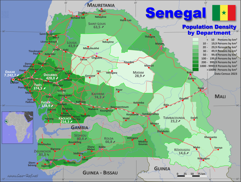
Senegal map - Click the map to get map as PDF file.
Other language versions are easy to generate, the descriptions are in own layers
Conditions for thematic maps with your own data and logotype
Delivery as printable file by e-mail or plot by post office
|
|---|
| Layers | |
| Provinces: | yes |
| Streets: | yes |
| Infrastructure: | yes |
| Rivers: | yes |
|
| Size | Till A2 |
| Delivery time | 7 working days | | Price |
| 1 bis 3 | 70 € | | > 3 | On request |
|
 |
All information published herein is free usable quoting the source,
including the maps, if they are not modified
|
|---|
Statistical data - Population density according to the administrative structure
The population data of the table below is census data from 2023, last available data.
Click on the column header brings the table in order of the column header.
The default order is the region name.
| Region |
ISO
3166-2 |
Capital |
Area
(km²) |
Population |
Density
(pers/km²) |
| Total |
|
|
196 685 |
18 032 471 |
91,7 |
|---|
| Last update: 12.06.2025 - 08:44:39 |
|---|
| Dakar |
SN-DK |
Dakar |
538 |
3 896 563 |
7 242,7 |
| Diourbel |
SN-DB |
Diourbel |
4 862 |
2 080 810 |
428,0 |
| Fatick |
SN-FK |
Fatick |
7 049 |
908 858 |
128,9 |
| Kaffrine |
SN-KA |
Kaffrine |
11 047 |
821 287 |
74,3 |
| Kaolack |
SN-KL |
Kaolack |
5 264 |
1 338 672 |
254,3 |
| Kéodugou |
SN-KE |
Kéodugou |
16 795 |
245 288 |
14,6 |
| Kolda |
SN-KD |
Kolda |
13 727 |
916 513 |
66,8 |
| Louga |
SN-LG |
Louga |
25 658 |
1 127 119 |
43,9 |
| Matam |
SN-MT |
Matam |
28 857 |
833 656 |
28,9 |
| Saint-Louis |
SN-SL |
Saint-Louis |
18 971 |
1 204 863 |
63,5 |
| Sédhiou |
SN-SE |
Sédhiou |
7 348 |
590 784 |
80,4 |
| Tambacounda |
SN-TC |
Tambacounda |
42 625 |
988 193 |
23,2 |
| Thies |
SN-TH |
Thies |
6 589 |
2 467 522 |
374,5 |
| Ziguinchor |
SN-ZG |
Ziguinchor |
7 355 |
612 343 |
83,3 |
The regions are divided into departments , the data of which are shown in the table below.
| Department |
Own |
Region |
Capital
| Area
(km²) |
Population |
Density
(pers/km²) |
| Total |
|
|
|
196 685 |
18 032 471 |
91,7 |
|---|
| Last update: 12.06.2025 - 08:44:39 |
|---|
| Bakel |
TC-1 |
Tambacounda |
Bakel |
6 707 |
190 501 |
28,4 |
| Bambey |
DB-1 |
Diourbel |
Bambey |
1 335 |
376 945 |
282,4 |
| Bignona |
ZG-1 |
Ziguinchor |
Bignona |
5 324 |
284 897 |
53,5 |
| Birkelane |
KA-1 |
Kaffrine |
Birkelane |
1 151 |
151 205 |
131,4 |
| Bounkiling |
SE-1 |
Sédhiou |
Bounkiling |
2 863 |
208 380 |
72,8 |
| Dagana |
SL-1 |
Saint-Louis |
Dagana |
5 247 |
330 130 |
62,9 |
| Dakar |
DK-1 |
Dakar |
Dakar |
80 |
1 182 417 |
14 780,2 |
| Diourbel |
DB-2 |
Diourbel |
Diourbel |
1 288 |
344 108 |
267,2 |
| Fatick |
FK-1 |
Fatick |
Fatick |
2 627 |
409 283 |
155,8 |
| Foundiougne |
FK-2 |
Fatick |
Foundiougne |
2 968 |
376 408 |
126,8 |
| Gossas |
FK-3 |
Fatick |
Gossas |
1 454 |
123 167 |
84,7 |
| Goudiry |
TC-2 |
Tambacounda |
Goudiry |
15 658 |
170 816 |
10,9 |
| Goudomp |
SE-2 |
Sédhiou |
Goudomp |
1 736 |
188 537 |
108,6 |
| Guédiawaye |
DK-2 |
Dakar |
Guédiawaye |
14 |
373 638 |
26 688,4 |
| Guinguinéo |
KL-1 |
Kaolack |
Guinguinéo |
1 082 |
160 483 |
148,3 |
| Kaffrine |
KA-2 |
Kaffrine |
Kaffrine |
2 661 |
280 969 |
105,6 |
| Kanel |
MT-1 |
Matam |
Kanel |
8 692 |
342 507 |
39,4 |
| Kaolack |
KL-2 |
Kaolack |
Kaolack |
1 882 |
665 008 |
353,4 |
| Kébémer |
LG-1 |
Louga |
Kébémer |
3 968 |
336 401 |
84,8 |
| Kédougou |
KE-1 |
Kédougou |
Kédougou |
7 067 |
124 265 |
17,6 |
| Keur Massar |
DK-5 |
Dakar |
Keur Massar Nord |
46 |
759 849 |
16 518,5 |
| Kolda |
KD-1 |
Kolda |
Kolda |
3 577 |
324 434 |
90,7 |
| Koumpentoum |
TC-3 |
Tambacounda |
Koumpentoum |
6 888 |
199 457 |
29,0 |
| Koungheul |
KA-3 |
Kaffrine |
Koungheul |
4 538 |
253 710 |
55,9 |
| Linguère |
LG-2 |
Louga |
Linguère |
16 020 |
312 831 |
19,5 |
| Louga |
LG-3 |
Louga |
Louga |
5 670 |
477 887 |
84,3 |
| Malem Hodar |
KA-4 |
Kaffrine |
Malem Hodar |
2 697 |
135 403 |
50,2 |
| Matam |
MT-2 |
Matam |
Matam |
5 754 |
387 866 |
67,4 |
| Mbacké |
DB-3 |
Diourbel |
Mbacké |
2 239 |
1 359 757 |
607,3 |
| Mbour |
TH-1 |
Thiès |
Mbour |
1 897 |
937 189 |
494,0 |
| Médina Yoro Foulah |
KD-2 |
Kolda |
Médina Yoro Foulah |
4 706 |
185 575 |
39,4 |
| Nioro du Rip |
KL-3 |
Kaolack |
Nioro du Rip |
2 300 |
513 181 |
223,1 |
| Oussouye |
ZG-2 |
Ziguinchor |
Oussouye |
890 |
52 883 |
59,4 |
| Pikine |
DK-3 |
Dakar |
Pikine |
42 |
758 554 |
18 060,8 |
| Podor |
SL-2 |
Saint-Louis |
Podor |
12 920 |
487 220 |
37,7 |
| Ranérou-Ferlo |
MT-3 |
Matam |
Ranérou |
14 411 |
103 283 |
7,2 |
| Rufisque |
DK-4 |
Dakar |
Rufisque |
356 |
822 105 |
2 309,3 |
| Saint-Louis |
SL-3 |
Saint-Louis |
Saint-Louis |
804 |
387 513 |
482,0 |
| Salémata |
KE-2 |
Kédougou |
Salémata |
1 918 |
28 111 |
14,7 |
| Saraya |
KE-3 |
Kédougou |
Saraya |
7 810 |
92 912 |
11,9 |
| Sédhiou |
SE-3 |
Sédhiou |
Sédhiou |
2 749 |
193 867 |
70,5 |
| Tambacounda |
TC-4 |
Tambacounda |
Tambacounda |
13 372 |
427 419 |
32,0 |
| Thiès |
TH-2 |
Thiès |
Thiès |
1 607 |
880 266 |
547,8 |
| Tivaouane |
TH-3 |
Thiès |
Tivaouane |
3 085 |
650 067 |
210,7 |
| Vélingara |
KD-3 |
Kolda |
Vélingara |
5 444 |
406 504 |
74,7 |
| Ziguinchor |
ZG-3 |
Ziguinchor |
Ziguinchor |
1 141 |
274 563 |
240,6 |
Existing thematic maps
|
External links change quickly - If you get a link error - Please inform us!
 |
Membership in international organisations and treaties
Expand list
Political Alliances
Regional Unions
Military alliances/Arms control
Law enforcement
Business Alliances
Fishery
Financial
Free Trade Area, Internal Market
Technical alliances
Transport
Cientific
Humanitarian Unions
Cultural Unions
|
|
If you have suggestions to include other information or you find missed links, please inform us!
Click here ... |
International Border disputes
Expand list
See also neighboring states
|
| |


