Central African Republic
Country map - Administrative structure - Population density of Central African Republic
Central African Republic map - Click the map to get map as PDF file.
Other language versions are easy to generate, the descriptions are in own layers
Conditions for thematic maps with your own data and logotype
Delivery as printable file by e-mail or plot by post office
|
|---|
| Layers | |
| Provinces: | yes |
| Streets: | yes |
| Infrastructure: | yes |
| Rivers: | yes |
|
| Size | Till A2 |
| Delivery time | 7 working days | | Price |
| 1 bis 3 | 70 € | | > 3 | On request |
|
 |
All information published herein is free usable quoting the source,
including the maps, if they are not modified
|
|---|
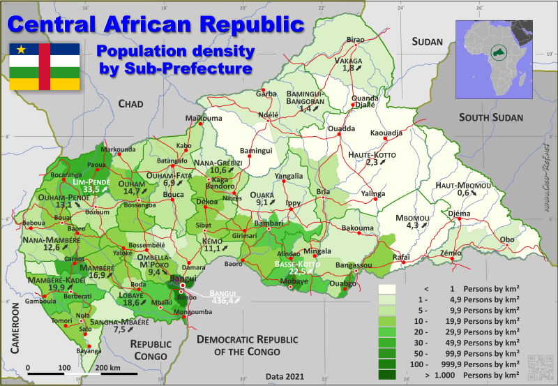
Statistical data - Population density according to the administrative structure
The population data of the table below is an estimation form 2021, last available data.
Click on the column header brings the table in order of the column header.
The default order is the prefecture name.
| Prefecture |
ISO
3166-2 |
Capital |
Area
(km²) |
Population |
Density
(pers/km²) |
| Total |
|
|
620 301 |
6 091 097 |
9,8 |
|---|
| Last update: 11/04/202 - 00:44:04 |
|---|
| Bamingui-Bangoran |
CF-BB |
Ndélé |
58 460 |
82 108 |
1,4 |
| Bangui |
CF-BGF |
Bangui |
3 266 |
1 425 276 |
436,4 |
| Basse-Kotto |
CF-BK |
Mobaye |
16 897 |
380 172 |
22,5 |
| Haute-Kotto |
CF-HK |
Bria |
56 349 |
128 342 |
2,3 |
| Haut-Mbomou |
CF-HM |
Obo |
86 050 |
52 314 |
0,6 |
| Kémo |
CF-KG |
Sibut |
16 506 |
183 742 |
11,1 |
| Lim-Pendé |
n.d. 1 |
Paoua |
13 208 |
442 151 |
33,5 |
| Lobaye |
CF-LB |
Mbaïki |
18 517 |
345 108 |
18,6 |
| Mambéré |
n.d. 2 |
Carnot |
15 736 |
265 479 |
16,9 |
| Mambéré-Kadéï |
CF-HS |
Berbérati |
13 737 |
273 166 |
19,9 |
| Mbomou |
CF-MB |
Bangassou |
60 241 |
257 803 |
4,3 |
| Nana-Gribizi |
CF-KB |
Kaga-Bandoro |
19 668 |
208 821 |
10,6 |
| Nana-Mambéré |
CF-NM |
Bouar |
27 200 |
341 796 |
12,6 |
| Ombella-M´Poko |
CF-MP |
Boali |
28 709 |
269 809 |
9,4 |
| Ouaka |
CF-UK |
Bambari |
49 130 |
446 354 |
9,1 |
| Ouham |
CF-AC |
Bossangoa |
20 245 |
297 904 |
14,7 |
| Ouham-Fafa |
n.d. 3 |
Batangoa |
32 533 |
225 479 |
6,9 |
| Ouham-Pendé |
CF-OP |
Bozoum |
18 519 |
243 315 |
13,1 |
| Sangha-Mbaéré |
CF-SE |
Nola |
18 591 |
138 770 |
7,5 |
| Vakaga |
CF-VR |
Birao |
46 739 |
83 188 |
1,8 |
The prefectiures are divided into sub-prefectiures, the data of which are shown in the table below
| Sub-Prefecture |
Own |
Prefecture |
Capital
| Area
(km²) |
Population |
Density
(pers/km²) |
| Total |
|
|
|
620 301 |
6 091 097 |
9,8 |
|---|
| Last update: 11/04/202 - 00:44:04 |
|---|
| Abba |
NM-1 |
Nana-Mambéré |
Abba |
3 900 |
31 257 |
8,0 |
| Alindao |
BK-1 |
Basse-Kotto |
Alindao |
4 860 |
125 040 |
25,7 |
| Amada-Gaza |
ND-2-1 |
Mambéré |
Amada-Gaza |
3 116 |
15 151 |
4,9 |
| Baboua |
NM-2 |
Nana-Mambéré |
Baboua |
8 964 |
77 278 |
8,6 |
| Bakala |
UK-1 |
Ouaka |
Bakala |
11 440 |
11 492 |
1,0 |
| Bakouma |
MB-1 |
Mbomou |
Bakouma |
17 510 |
28 703 |
1,6 |
| Bambari |
UK-2 |
Ouaka |
Bambari |
7 972 |
216 534 |
27,2 |
| Bambio |
SE-1 |
Sangha-Mbaéré |
Bambio |
5 711 |
24 664 |
4,3 |
| Bambouti |
HM-1 |
Haut-Mbomou |
Bambouti |
4 722 |
310 |
0,1 |
| Bamingui |
BB-1 |
Bamingui-Bangoran |
Bamingui |
22 030 |
10 284 |
0,5 |
| Bangassou |
MB-2 |
Mbomou |
Bangassou |
7 367 |
111 208 |
15,1 |
| Bangui |
BGF-1 |
Bangui |
Bangui |
66 |
812 407 |
12 309,2 |
| Baoro |
NM-3 |
Nana-Mambéré |
Baoro |
5 324 |
58 207 |
10,9 |
| Batangafo |
ND-3-1 |
Ouham-Fafa |
Batangafo |
9 407 |
88 407 |
9,4 |
| Bayanga |
SE-2 |
Sangha-Mbaéré |
Bayanga |
3 996 |
18 556 |
4,6 |
| Bégoua |
BGF-2 |
Bangui |
Bégoua |
1 300 |
264 067 |
203,1 |
| Berbérati |
HS-1 |
Mambéré-Kadéï |
Berbérati |
9 042 |
189 813 |
21,0 |
| Bimbo |
BGF-3 |
Bangui |
Bimbo |
1 900 |
348 802 |
183,6 |
| Birao |
VR-1 |
Vakaga |
Birao |
37 830 |
76 267 |
2,0 |
| Boali |
MP-1 |
Ombella-M´Poko |
Boali |
4 760 |
62 071 |
13,0 |
| Bocaranga |
OP-1 |
Ouham-Pendé |
Bocaranga |
4 586 |
102 297 |
22,3 |
| Boda |
LB-1 |
Lobaye |
Boda |
3 111 |
64 013 |
20,6 |
| Boganangone |
LB-2 |
Lobaye |
Boganangone |
2 974 |
39 115 |
13,2 |
| Boganda |
LB-3 |
Lobaye |
Boganda |
2 753 |
19 823 |
7,2 |
| Bogangolo |
MP-2 |
Ombella-M´Poko |
Bogangolo |
4 809 |
9 801 |
2,0 |
| Bossangoa |
AC-1 |
Ouham |
Bossangoa |
11 730 |
167 214 |
14,3 |
| Bossembélé |
MP-3 |
Ombella-M´Poko |
Bossembélé |
7 403 |
58 504 |
7,9 |
| Bossemptélé |
OP-2 |
Ouham-Pendé |
Bossemptélé |
3 659 |
24 328 |
6,6 |
| Bouar |
NM-4 |
Nana-Mambéré |
Bouar |
9 012 |
175 054 |
19,4 |
| Bouca |
ND-3-2 |
Ouham-Fafa |
Bouca |
14 610 |
80 531 |
5,5 |
| Bozoum |
OP-3 |
Ouham-Pendé |
Bozoum |
7 812 |
75 139 |
9,6 |
| Bria |
HK-1 |
Haute-Kotto |
Bria |
16 230 |
102 356 |
6,3 |
| Carnot |
ND-2-2 |
Mambéré |
Carnot |
3 707 |
159 987 |
43,2 |
| Damara |
MP-4 |
Ombella-M´Poko |
Damara |
6 880 |
56 755 |
8,2 |
| Dédé-Makouba |
HS-2 |
Mambéré-Kadéï |
Dédé-Makouba |
1 063 |
23 708 |
22,3 |
| Dékoa |
KG-1 |
Kémo |
Dékoa |
3 701 |
57 254 |
15,5 |
| Djemah |
HM-2 |
Haut-Mbomou |
Djemah |
36 230 |
2 484 |
0,1 |
| Gadzi |
ND-2-3 |
Mambéré |
Gadzi |
6 423 |
72 071 |
11,2 |
| Gambo |
MB-3 |
Mbomou |
Gambo |
6 419 |
33 294 |
5,2 |
| Gamboula |
HS-3 |
Mambéré-Kadéï |
Gamboula |
2 778 |
41 196 |
14,8 |
| Grimari |
UK-3 |
Ouaka |
Grimari |
5 037 |
51 275 |
10,2 |
| Ippy |
UK-4 |
Ouaka |
Ippy |
17 120 |
59 290 |
3,5 |
| Kabo |
ND-3-3 |
Ouham-Fafa |
Kabo |
1 830 |
16 064 |
8,8 |
| Kaga-Bandoro |
KB-1 |
Nana-Grébizi |
Kaga-Bandoro |
8 494 |
143 186 |
16,9 |
| Kembé |
BK-2 |
Basse-Kotto |
Kembé |
2 280 |
46 050 |
20,2 |
| Kodi |
ND-1-1 |
Lim-Pendé |
Kodi |
2 100 |
43 985 |
20,9 |
| Kouango |
UK-5 |
Ouaka |
Kouango |
7 561 |
107 763 |
14,3 |
| Koui |
OP-4 |
Ouham-Pendé |
Koui |
2 462 |
41 551 |
16,9 |
| Mala |
KG-2 |
Kémo |
Mala |
2 099 |
19 680 |
9,4 |
| Markounda |
AC-2 |
Ouham |
Markounda |
4 402 |
37 399 |
8,5 |
| Mbaïki |
LB-4 |
Lobaye |
Mbaïki |
8 694 |
188 263 |
21,7 |
| Mbrès |
KB-2 |
Nana-Grébizi |
Mbrès |
3 490 |
33 323 |
9,5 |
| Mingala |
BK-3 |
Basse-Kotto |
Mingala |
4 586 |
39 672 |
8,7 |
| Mobaye |
BK-4 |
Basse-Kotto |
Mobaye |
1 525 |
81 498 |
53,4 |
| Mongoumba |
LB-5 |
Lobaye |
Mongoumba |
985 |
33 894 |
34,4 |
| Nana-Bakassa |
AC-3 |
Ouham |
Nana-Bakassa |
1 966 |
55 642 |
28,3 |
| Nana-Outa |
KB-3 |
Nana-Grébizi |
Nana-Outa |
7 684 |
32 312 |
4,2 |
| Nanga Boguila |
AC-4 |
Ouham |
Nanga Boguila |
2 147 |
37 649 |
17,5 |
| Ndélé |
BB-2 |
Bamingui-Bangoran |
Ndélé |
36 430 |
71 824 |
2,0 |
| Ndjoukou |
KG-3 |
Kémo |
Galabadja |
5 908 |
46 627 |
7,9 |
| Ngaoundaye |
ND-1-2 |
Lim-Pendé |
Ngaoundaye |
2 191 |
90 994 |
41,5 |
| Nola |
SE-3 |
Sangha-Mbaéré |
Nola |
8 884 |
95 550 |
10,8 |
| Obo |
HM-3 |
Haut-Mbomou |
Obo |
7 206 |
20 100 |
2,8 |
| Ouadda |
HK-2 |
Haute-Kotto |
Ouadda |
28 490 |
21 424 |
0,8 |
| Ouanda Djallé |
VR-2 |
Vakaga |
Ouanda Djallé |
8 909 |
6 921 |
0,8 |
| Ouango |
MB-4 |
Mbomou |
Ouango |
1 335 |
62 662 |
46,9 |
| Paoua |
ND-1-3 |
Lim-Pendé |
Paoua |
8 917 |
307 172 |
34,4 |
| Rafaï |
MB-5 |
Mbomou |
Rafaï |
27 610 |
21 936 |
0,8 |
| Satéma |
BK-5 |
Basse-Kotto |
Satéma |
1 308 |
37 097 |
28,4 |
| Senkpa-Mbaéré |
ND-2-4 |
Mambéré |
Senkpa-Mbaéré |
2 490 |
18 270 |
7,3 |
| Sibut |
KG-4 |
Kémo |
Sibut |
4 798 |
60 181 |
12,5 |
| Sido |
ND-3-4 |
Ouham-Fafa |
Sido |
6 686 |
40 477 |
6,1 |
| Sosso-Nakombo |
HS-4 |
Mambéré-Kadéï |
Sosso-Nakombo |
854 |
18 449 |
21,6 |
| Yalinga |
HK-3 |
Haute-Kotto |
Yalinga |
41 330 |
4 562 |
0,1 |
| Yaloké |
MP-5 |
Ombella-M´Poko |
Yaloké |
4 857 |
82 678 |
17,0 |
| Zangba |
BK-6 |
Basse-Kotto |
Zangba |
2 338 |
50 815 |
21,7 |
| Zémio |
HM-4 |
Haut-Mbomou |
Zémio |
8 191 |
29 420 |
3,6 |
Existing thematic maps
|
External links change quickly - If you get a link error - Please inform us!
 |
Membership in international organisations and treaties
Expand list
Political Alliances
Regional Unions
Military alliances/Arms control
Law enforcement
Business Alliances
Financial
Free Trade Area, Internal Market
Technical alliances
Transport
Cientific
Humanitarian Unions
Cultural Unions
|
|
If you have suggestions to include other information or you find missed links, please inform us!
Click here ... |
International Border disputes
Expand list
See also neighboring states
|
| |


