Republic of South Sudan
| Capital |
Currency | Government system |
|---|
| Juba |
South Sudanese Pound (SSP) |
Presidential system |
| Official language | Region |
Population |
|---|
| English |
Africa |
Estimation 2017
11 843 929 |
Country map - Administrative structure - Population density of South Sudan
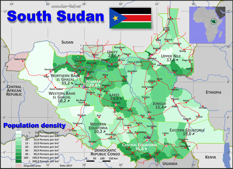
South Sudan map - Click the map to get map as PDF file.
Other language versions are easy to generate, the descriptions are in own layers
Conditions for thematic maps with your own data and logotype
Delivery as printable file by e-mail or plot by post office
|
|---|
| Layers | |
| Provinces: | yes |
| Streets: | yes |
| Infrastructure: | yes |
| Rivers: | yes |
|
| Size | Till A2 |
| Delivery time | 7 working days | | Price |
| 1 bis 3 | 65 € | | > 3 | On request |
|
 |
All information published herein is free usable quoting the source,
including the maps, if they are not modified
|
|---|
Statistical data - Population density according to the administrative structure
The population data of the table below is an estimation form 2017, last available data.
Click on the column header brings the table in order of the column header.
The default order is the state name.
| State |
ISO
3166-2 |
Capital |
Area
(km²) |
Population |
Density
(pers/km²) |
| Total |
|
|
643 662 |
11 843 929 |
18,4 |
|---|
| Last update: 11/04/202 - 00:44:04 |
|---|
| Central Equatoria |
SS-CE |
Juba |
43 104 |
1 576 286 |
36,6 |
| Eastern Equatoria |
SS-EE |
Torit |
73 175 |
1 393 764 |
19,0 |
| Jonglei |
SS-JG |
Bor |
121 873 |
1 878 795 |
15,4 |
| Lakes |
SS-LK |
Rumbek |
43 236 |
1 053 176 |
24,4 |
| Northern Bahr el Ghazal |
SS-BN |
Aweil |
30 828 |
1 023 384 |
33,2 |
| Unity |
SS-UY |
Bentiu |
37 131 |
876 188 |
23,6 |
| Upper Nile |
SS-UN |
Malakal |
77 773 |
1 385 477 |
17,8 |
| Warrap |
SS-WR |
Kuajok |
46 360 |
1 379 959 |
29,8 |
| Western Bahr el Ghazal |
SS-BW |
Wau |
91 254 |
473 636 |
5,2 |
| Western Equatoria |
SS-WE |
Yambio |
78 928 |
803 264 |
10,2 |
The states are divided into counties, the data of which are shown in the table below.
| County |
Own |
State |
Capital
| Area
(km²) |
Population |
Density
(pers/km²) |
| Total |
|
|
|
643 662 |
11 843 929 |
18,4 |
|---|
| Last update: 11/04/202 - 00:44:04 |
|---|
| Abiemnhom |
UY-01 |
Unity |
Abiemnhom |
2 409 |
25 384 |
10,5 |
| Abyei - disputed area |
WR-01 |
Warrap |
Abyei Town |
10 498 |
74 518 |
7,1 |
| Akobo |
JG-01 |
Jonglei |
Akobo |
9 000 |
192 937 |
21,4 |
| Akoka |
UN-01 |
Upper Nile |
Benythieng |
6778 |
14 201 |
2,1 |
| Aweil Centre |
BN-01 |
Northern Bahr el Ghazal |
Aweil |
11 147 |
59 356 |
5,3 |
| Aweil East |
BN-02 |
Northern Bahr el Ghazal |
Wanyjok |
6 363 |
440 055 |
69,2 |
| Aweil North |
BN-03 |
Northern Bahr el Ghazal |
Gok Machar |
6 338 |
183 186 |
28,9 |
| Aweil South |
BN-04 |
Northern Bahr el Ghazal |
Nyamlell |
1 976 |
104 385 |
52,8 |
| Aweil West |
BN-05 |
Northern Bahr el Ghazal |
Aweil West |
5 004 |
236 402 |
47,2 |
| Awerial |
LK-01 |
Lakes |
Awerial |
4 544 |
71 616 |
15,8 |
| Ayod |
JG-02 |
Jonglei |
Ayod |
13 449 |
192 937 |
14,3 |
| Baliet |
UN-02 |
Upper Nile |
Baliet |
5545 |
55 073 |
9,9 |
| Bor South |
JG-03 |
Jonglei |
Bor |
13 932 |
305 328 |
21,9 |
| Budi |
EE-01 |
Eastern Equatoria |
Chukudum |
5 727 |
153 314 |
26,8 |
| Canal/Pigi |
JG-04 |
Jonglei |
Nyintharkmalual |
4 445 |
136 742 |
30,8 |
| Cueibet |
LK-02 |
Lakes |
Cueibet |
4 866 |
177 987 |
36,6 |
| Duk |
JG-05 |
Jonglei |
Duk Padiet |
6 861 |
89 912 |
13,1 |
| Ezo |
WE-01 |
Western Equatoria |
Ezo |
8 068 |
105 228 |
13,0 |
| Fangak |
JG-06 |
Jonglei |
Fam al Zaraf |
7 735 |
151 727 |
19,6 |
| Fashoda |
UN-03 |
Upper Nile |
Kodok |
3 582 |
52 648 |
14,7 |
| Gogrial East |
WR-02 |
Warrap |
Liet-Nhom |
4 425 |
146 276 |
33,1 |
| Gogrial West |
WR-03 |
Warrap |
Kuajok |
4 399 |
346 370 |
78,7 |
| Guit |
UY-02 |
Unity |
Gholyil Rar |
3 456 |
49 018 |
14,2 |
| Ibba |
WE-02 |
Western Equatoria |
Ibba |
9 613 |
54 622 |
5,7 |
| Ikotos |
EE-02 |
Eastern Equatoria |
Ikotos |
3 512 |
129 620 |
36,9 |
| Juba |
CE-01 |
Central Equatoria |
Juba |
18 362 |
525 953 |
28,6 |
| Jur River |
BW-01 |
Western Bahr el Ghazal |
Nyin Akok |
10 044 |
181 402 |
18,1 |
| Kajo-Keji |
CE-02 |
Central Equatoria |
Kajo-Keji |
2 518 |
280 299 |
111,3 |
| Kapoeta East |
EE-03 |
Eastern Equatoria |
Narus |
29 638 |
252 271 |
8,5 |
| Kapoeta North |
EE-04 |
Eastern Equatoria |
Riwoto |
5 732 |
158 889 |
27,7 |
| Kapoeta South |
EE-05 |
Eastern Equatoria |
Kapoeta |
1 199 |
122 651 |
102,3 |
| Koch |
UY-03 |
Unity |
Koch |
4 417 |
112 040 |
25,4 |
| Lafon |
EE-06 |
Eastern Equatoria |
Lafon |
16 330 |
163 071 |
10,0 |
| Lainya |
CE-03 |
Central Equatoria |
Lainya |
3 500 |
127 552 |
36,4 |
| Leer |
UY-04 |
Unity |
Leer |
1 633 |
79 653 |
48,8 |
| Longochuk |
UN-04 |
Upper Nile |
Mathiang |
6 916 |
91 442 |
13,2 |
| Luakpiny/Nasir |
UN-05 |
Upper Nile |
Nasir |
5 188 |
302 034 |
58,2 |
| Maban |
UN-06 |
Upper Nile |
Bunj |
11 818 |
65 117 |
5,5 |
| Magwi |
EE-07 |
Eastern Equatoria |
Magwi |
5 202 |
260 634 |
50,1 |
| Maiwut |
UN-07 |
Upper Nile |
Maiwut |
3 689 |
113 609 |
30,8 |
| Malakal |
UN-08 |
Upper Nile |
Malakal |
754 |
181 498 |
240,7 |
| Manyo |
UN-09 |
Upper Nile |
Kaka |
6 671 |
54 034 |
8,1 |
| Maridi |
WE-03 |
Western Equatoria |
Maridi |
7 692 |
106 834 |
13,9 |
| Mayendit |
UY-05 |
Unity |
Maal |
3 067 |
80 529 |
26,3 |
| Mayom |
UY-06 |
Unity |
Mayom |
4 263 |
180 314 |
42,3 |
| Melut |
UN-10 |
Upper Nile |
Melut |
6 948 |
70 659 |
10,2 |
| Morobo |
CE-04 |
Central Equatoria |
Morobo |
1 304 |
148 023 |
113,5 |
| Mundri East |
WE-04 |
Western Equatoria |
Kediba |
5 079 |
62 655 |
12,3 |
| Mundri West |
WE-05 |
Western Equatoria |
Mundri |
5 878 |
44 179 |
7,5 |
| Mvolo |
WE-06 |
Western Equatoria |
Mvolo |
5 725 |
62 655 |
10,9 |
| Nagero |
WE-07 |
Western Equatoria |
Nagero |
9 192 |
12 852 |
1,4 |
| Nyirol |
JG-07 |
Jonglei |
Thol |
7 087 |
149 854 |
21,1 |
| Nzara |
WE-08 |
Western Equatoria |
Nzara |
6 442 |
85 146 |
13,2 |
| Panyijar |
UY-07 |
Unity |
Tiap |
5 340 |
76 152 |
14,3 |
| Panyikang |
UN-11 |
Upper Nile |
Panyikang |
5 038 |
65 117 |
12,9 |
| Pariang |
UY-08 |
Unity |
Pariang |
8 977 |
123 419 |
13,7 |
| Pibor |
JG-08 |
Jonglei |
Pibor |
32 998 |
204 176 |
6,2 |
| Pochalla |
JG-09 |
Jonglei |
Pochalla |
8 267 |
91 786 |
11,1 |
| Raga |
BW-02 |
Western Bahr el Ghazal |
Raga |
62 013 |
77 203 |
1,2 |
| Renk |
UN-12 |
Upper Nile |
Renk |
10 019 |
198 123 |
19,8 |
| Rubkona |
UY-09 |
Unity |
Rubkona |
3 569 |
149 679 |
41,9 |
| Rumbek Centre |
LK-03 |
Lakes |
Rumbek |
3 856 |
232 752 |
60,4 |
| Rumbek East |
LK-04 |
Lakes |
Thon-Aduel |
3 573 |
186 412 |
52,2 |
| Rumbek North |
LK-05 |
Lakes |
Maper |
4 110 |
65 297 |
15,9 |
| Tambura |
WE-09 |
Western Equatoria |
Tambura |
12 447 |
71 490 |
5,7 |
| Terekeka |
CE-05 |
Central Equatoria |
Terekeka |
10 690 |
206 287 |
19,3 |
| Tonj East |
WR-04 |
Warrap |
Romic |
4 425 |
164 215 |
37,1 |
| Tonj North |
WR-05 |
Warrap |
Lou Paher |
11 232 |
234 593 |
20,9 |
| Tonj South |
WR-06 |
Warrap |
Tonj Town |
7 424 |
122 816 |
16,5 |
| Torit |
EE-08 |
Eastern Equatoria |
Torit |
5 835 |
153 314 |
26,3 |
| Twic |
WR-07 |
Warrap |
Wun Rog |
3 957 |
291 171 |
73,6 |
| Twic East |
JG-10 |
Jonglei |
Kongor |
5 936 |
118 010 |
19,9 |
| Ulang |
UN-13 |
Upper Nile |
Ulang |
4 827 |
121 922 |
25,3 |
| Uror |
JG-11 |
Jonglei |
Uror |
12 163 |
245 386 |
20,2 |
| Wau |
BW-03 |
Western Bahr el Ghazal |
Wau |
19 197 |
215 031 |
11,2 |
| Wulu |
LK-06 |
Lakes |
Wulu |
11 852 |
61 084 |
5,2 |
| Yambio |
WE-10 |
Western Equatoria |
Yambio |
8 792 |
197 603 |
22,5 |
| Yei |
CE-06 |
Central Equatoria |
Yei |
6 730 |
288 172 |
42,8 |
| Yirol East |
LK-07 |
Lakes |
Karair |
5 584 |
102 158 |
18,3 |
| Yirol West |
LK-08 |
Lakes |
Yirol |
4 851 |
155 870 |
32,1 |
Existing thematic maps
|
External links change quickly - If you get a link error - Please inform us!
 |
Membership in international organisations and treaties
Expand list
Political Alliances
Regional Unions
Military alliances/Arms control
Law enforcement
Business Alliances
Financial
Free Trade Area, Internal Market
Technical alliances
Transport
Cientific
Humanitarian Unions
Cultural Unions
|
|
If you have suggestions to include other information or you find missed links, please inform us!
Click here ... |
International Border disputes
Expand list
See also neighboring states
|
| |


