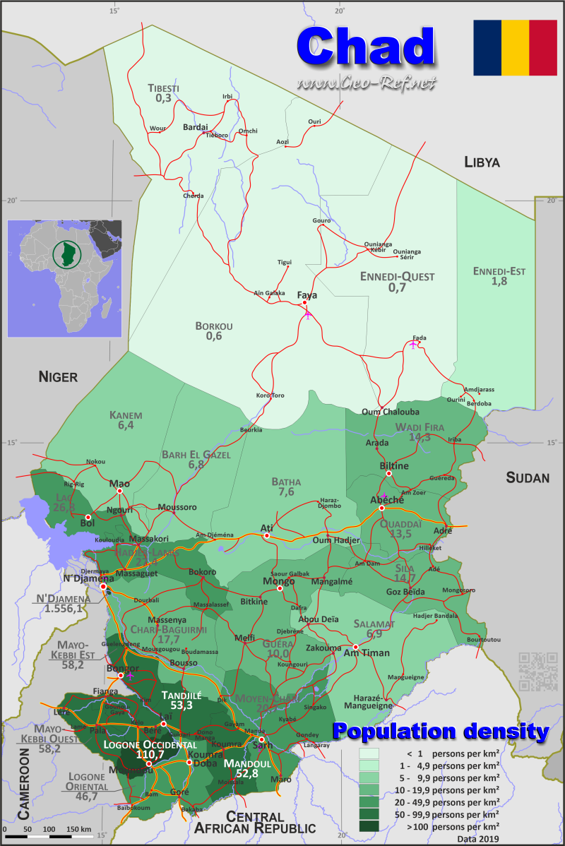
Republic of Chad
Country map - Administrative structure - Population density of Chad

Chad map - Click the map to get map as PDF file.
Other language versions are easy to generate, the descriptions are in own layers
Conditions for thematic maps with your own data and logotype
Delivery as printable file by e-mail or plot by post office
|
|---|
| Layers | |
| Provinces: | yes |
| Streets: | yes |
| Infrastructure: | yes |
| Rivers: | yes |
|
| Size | Till A2 |
| Delivery time | 7 working days | | Price |
| 1 bis 3 | 65 € | | > 3 | On request |
|
 |
All information published herein is free usable quoting the source,
including the maps, if they are not modified
|
|---|
Statistical data - Population density according to the administrative structure
The population data of the table below is an estimation form 2019, last available data.
Click on the column header brings the table in order of the column header.
The default order is the region name.
| Region |
ISO
3166-2 |
Arabic |
Capital |
Area
(km²) |
Population |
Density
(pers/km²) |
| Total |
|
|
|
1 327 263 |
15 775 200 |
11,9 |
|---|
| Last update: 05.06.2025 - 00:37:41 |
|---|
| Barh El Gazel |
TD-BG |
بحر الغزال |
Moussoro |
53 000 |
361 100 |
6,8 |
| Batha |
TD-BA |
البطحة |
Ati |
88 000 |
667 600 |
7,6 |
| Borkou |
TD-BO |
بوركو |
Faya-Largeau |
241 000 |
133 600 |
0,6 |
| Chari-Baguirmi |
TD-CB |
شاري باقرمي |
Massenya |
46 000 |
816 300 |
17,7 |
| Ennedi-Est |
TD-EE |
إنيدي الشرقية |
Amdjarass |
85 000 |
152 900 |
1,8 |
| Ennedi-Ouest |
TD-EO |
منطقة إنيدي |
Fada |
125 000 |
86 400 |
0,7 |
| Guéra |
TD-GR |
قيرا |
Mongo |
62 000 |
622 200 |
10,0 |
| Hadjer-Lamis |
TD-HL |
حجر لميس |
Massakory |
29 000 |
794 300 |
27,4 |
| Kanem |
TD-KA |
كانم |
Mao |
75 000 |
481 100 |
6,4 |
| Lac |
TD-LC |
البحيرة |
Bol |
23 000 |
617 000 |
26,8 |
| Logone Occidental |
TD-LO |
لوقون الغربي |
Moundou |
9 000 |
996 400 |
110,7 |
| Logone Oriental |
TD-LR |
لوقون الشرقي |
Doba |
24 000 |
1 121 000 |
46,7 |
| Mandoul |
TD-MA |
ماندول |
Koumra |
17 000 |
897 100 |
52,8 |
| Mayo-Kebbi Est |
TD-ME |
مايو كيبي الشرقي |
Bongor |
19 000 |
1 106 500 |
58,2 |
| Mayo-Kebbi Ouest |
TD-MO |
مايو كيبي الغربي |
Pala |
14 000 |
815 100 |
58,2 |
| Moyen-Chari |
TD-MC |
شاري الأوسط |
Sarh |
41 000 |
847 500 |
20,7 |
| N´Djamena |
TD-ND |
نجامين |
National capital |
978 |
1 521 900 |
1 556,1 |
| Ouaddaï |
TD-OD |
وداي |
Abéché |
76 240 |
1 032 500 |
13,5 |
| Salamat |
TD-SA |
سلامات |
Am Timan |
63 000 |
434 900 |
6,9 |
| Sila |
TD-SI |
سيلا |
Goz Beïda |
37 000 |
544 200 |
14,7 |
| Tandjilé |
TD-TA |
تانجلي |
Laï |
18 045 |
960 900 |
53,3 |
| Tibesti |
TD-TI |
تبستي |
Bardaï |
130 000 |
36 500 |
0,3 |
| Wadi Fira |
TD-WF |
وادي فيرا |
Biltine |
51 000 |
728 200 |
14,3 |
Existing thematic maps
|
External links change quickly - If you get a link error - Please inform us!
 |
Membership in international organisations and treaties
Expand list
Political Alliances
Regional Unions
Military alliances/Arms control
Law enforcement
Business Alliances
Financial
Free Trade Area, Internal Market
Technical alliances
Transport
Cientific
Humanitarian Unions
Cultural Unions
 |
If you have suggestions to include other information or you find missed links, please inform us!
Click here ... |
International Border disputes
Expand list
See also neighboring states
|
| |


