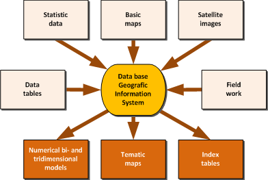
GIS consulting
GIS - system is a geographic information system, used for the
collection of geographic information with the objective to map the
information with special software and in huger format using plotter. The
required equipment for such systems is very specialized and usually only
installed in special enterprises.
 The
usual standard is defined more or less by the enterprise ESRI - mostly
based in the series of products ARC Info … requiring higher
technological equipment in graphics and data processing. Main problem
for such a system is the data base, and the maintenance given to the
same. Usually with the data structure is defined the performance of the
system, using as input the special thematic focus of the data as
parameter for the optimization. Frequently are used the standard data
structure of the ESRI software, degrading so the performance of the
system. Exactly this issues and the graphic conversion is the main
problem of GIS consultations. The
usual standard is defined more or less by the enterprise ESRI - mostly
based in the series of products ARC Info … requiring higher
technological equipment in graphics and data processing. Main problem
for such a system is the data base, and the maintenance given to the
same. Usually with the data structure is defined the performance of the
system, using as input the special thematic focus of the data as
parameter for the optimization. Frequently are used the standard data
structure of the ESRI software, degrading so the performance of the
system. Exactly this issues and the graphic conversion is the main
problem of GIS consultations.
Other problem is the configuration of the ESRI software modules,
which are on one hand very expansive in price, on other hand very
specific in the requests of training. As one possible and frequently
used modification in the modules configuration is used AutoCad instead
of ARC-CAD, using so the lower price of AutoCad and the fact that the
training for AutoCad is more accessible and common. Using the import
functions of ARC Info it`s also a fully valid solution, solving the
problem of training.
Similar is the situation with other GIS products, like mapinfo, etc.
We are prepared for assistance in all GIS related problems ...
|