Federal Republic of Somalia
| Capital |
Currency | Government system |
|---|
| Mogadischu |
Somali Shilling (SOS) |
Parliamentary democracy |
| Official language | Region |
Population |
|---|
Somali
Arabic |
Africa |
Estimation 2019
15 625 900 |
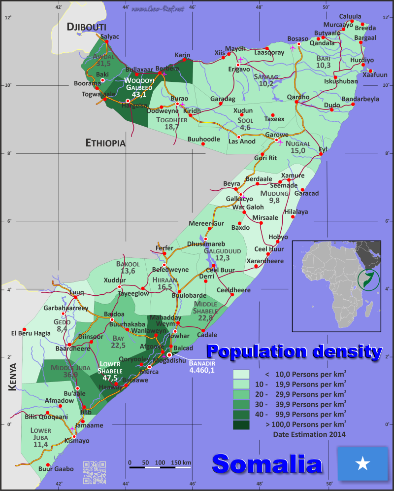
Country map - Administrative structure - Population density of Somalia
Somalia map - Click the map to get map as PDF file.
Other language versions are easy to generate, the descriptions are in own layers
Conditions for thematic maps with your own data and logotype
Delivery as printable file by e-mail or plot by post office
|
|---|
| Layers | |
| Provinces: | yes |
| Streets: | yes |
| Infrastructure: | yes |
| Rivers: | yes |
|
| Size | Till A2 |
| Delivery time | 7 working days | | Price |
| 1 bis 3 | 65 € | | > 3 | On request |
|
 |
All information published herein is free usable quoting the source,
including the maps, if they are not modified
|
|---|
Statistical data - Population density according to the administrative structure
The population data of the table below is an estimation form 2019, last available data.
Click on the column header brings the table in order of the column header.
The default order is the state name.
| State |
ISO
3166-2 |
Arabic |
Capital |
Area
(km²) |
Population |
Density
(pers/km²) |
| Total |
|
|
|
637 657 |
15 625 900 |
24,5 |
|---|
| Last update: 12.06.2025 - 08:44:39 |
|---|
| Awdal |
SO-AW |
أودال |
Borama |
21 374 |
1 010 600 |
47,3 |
| Bakool |
SO-BK |
باكول |
Xuddur |
26 962 |
383 400 |
14,2 |
| Banaadir |
SO-BN |
بنادر |
Mogadishu |
370 |
2 330 700 |
6 299,2 |
| Bari |
SO-BR |
باري |
Bosaso |
70 088 |
949 700 |
13,6 |
| Bay |
SO-BY |
باي |
Baidoa |
35 156 |
1 035 900 |
29,5 |
| Galguduud |
SO-GA |
غالغدود |
Dhusamareb |
46 126 |
634 300 |
13,8 |
| Gedo |
SO-GE |
غدو |
Garbahaarreey |
60 389 |
566 300 |
9,4 |
| Hiiraan |
SO-HI |
هيران |
Beledweyne |
31 510 |
566 400 |
18,0 |
| Lower Juba |
SO-JH |
جوبا السفلى |
Kismayo |
42 876 |
632 900 |
14,8 |
| Lower Shabele |
SO-JH |
شبيلي السفلى |
Merca |
25 285 |
1 218 700 |
48,2 |
| Middle Juba |
SO-JD |
جوبا الوسطى |
Bu´aale |
9 836 |
432 200 |
43,9 |
| Middle Shabele |
SO-JD |
شبيلي الوسطى |
Jowhar |
22 663 |
622 700 |
27,5 |
| Mudug |
SO-MU |
مدق |
Galkacyo |
72 933 |
864 700 |
11,9 |
| Nugaal |
SO-NU |
نوغال |
Garowe |
26 180 |
473 900 |
18,1 |
| Sanaag |
SO-SA |
سناغ |
Erigavo |
53 374 |
578 100 |
10,8 |
| Sool |
SO-SO |
صول |
Las Anod |
25 036 |
618 600 |
24,7 |
| Togdheer |
SO-TO |
توغدير |
Burao |
38 663 |
962 400 |
24,9 |
| Woqooyi Galbeed |
SO-WO |
وقوي غلبيد |
Hargeisa |
28 836 |
1 744 400 |
60,5 |
Existing thematic maps
|
External links change quickly - If you get a link error - Please inform us!
 |
Membership in international organisations and treaties
Expand list
Political Alliances
Regional Unions
Military alliances/Arms control
Law enforcement
Business Alliances
Fishery
Financial
Free Trade Area, Internal Market
Technical alliances
Transport
Cientific
Humanitarian Unions
Cultural Unions
|
|
If you have suggestions to include other information or you find missed links, please inform us!
Click here ... |
International Border disputes
Expand list
See also neighboring states
|
| |


