Republic of Mauritius
| Capital |
Currency | Government system |
|---|
| Port Louis |
Mauritian Rupee (MUR) |
Parliamentary democracy |
| Official language | Region |
Population |
|---|
English
French |
Africa |
Census 2022
1 233 467 |
Country map - Administrative structure - Population density of Mauritius
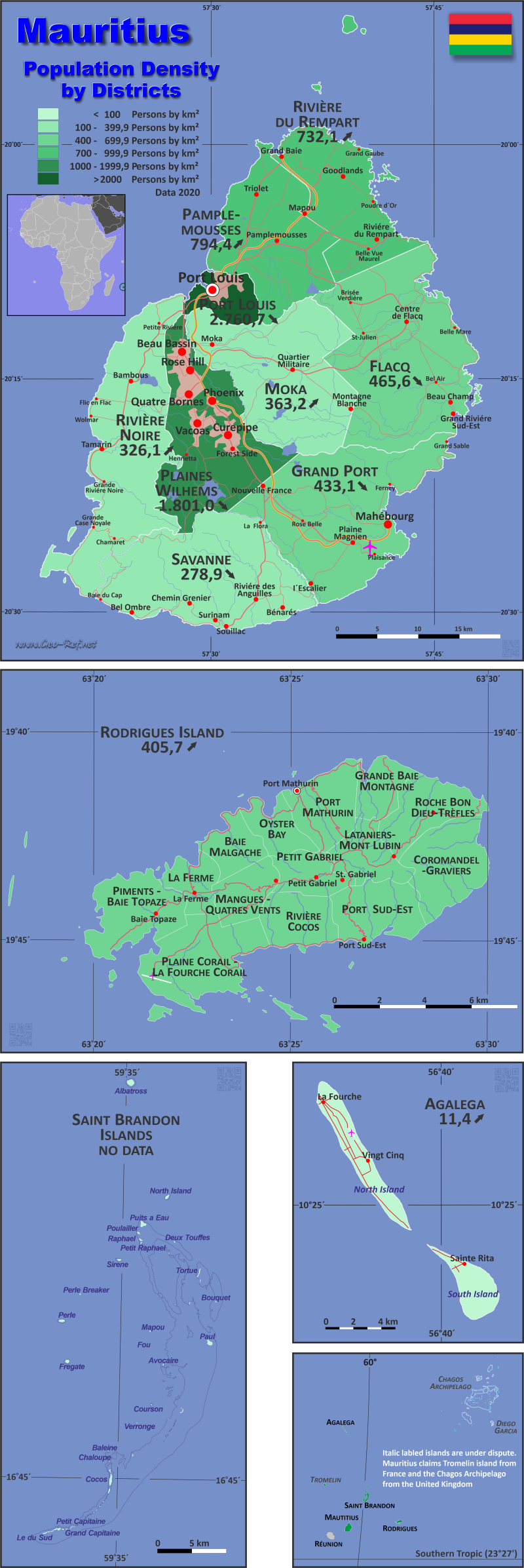
Mauritius map - Click the map to get map as PDF file.
Other language versions are easy to generate, the descriptions are in own layers
Conditions for thematic maps with your own data and logotype
Delivery as printable file by e-mail or plot by post office
|
|---|
| Layers | |
| Provinces: | yes |
| Streets: | yes |
| Infrastructure: | yes |
| Rivers: | yes |
|
| Size | Till A2 |
| Delivery time | 7 working days | | Price |
| 1 bis 3 | 65 € | | > 3 | On request |
|
 |
All information published herein is free usable quoting the source,
including the maps, if they are not modified
|
|---|
Statistical data - Population density according to the administrative structure
The population data of the table below is census data from 2022, last available data.
Click on the column header brings the table in order of the column header.
The default order is the district / dependency name.
| District / Dependency |
ISO
3166-2 |
Type |
Capital |
Area
(km²) |
Population |
Density
(pers/km²) |
| Total |
|
|
|
1 998,9 |
1 233 467 |
617,1 |
|---|
| Last update: 12.06.2025 - 08:44:38 |
|---|
| Agalega Islands |
MU-AG |
Dependency |
Vingt Cinq |
24,0 |
330 |
13,8 |
| Flacq |
MU-FL |
District |
Centre de Flacq |
297,9 |
138 529 |
465,0 |
| Grand Port |
MU-GP |
District |
Mahébourg |
260,3 |
110 783 |
425,6 |
| Moka |
MU-MO |
District |
Moka |
230,5 |
85 538 |
371,1 |
| Pamplemousses |
MU-PA |
District |
Triolet |
178,7 |
140 856 |
788,2 |
| Plaines Wilhems |
MU-PW |
District |
Beau Bassin-Rose Hill |
203,3 |
340 780 |
1 676,2 |
| Port Louis |
MU-PL |
District |
Port Louis |
42,7 |
106 332 |
2 490,2 |
| Rivière du Rempart |
MU-RR |
District |
Mapou |
147,6 |
111 195 |
753,4 |
| Rivière Noire |
MU-BL |
District |
Tamarin |
259,0 |
87 701 |
338,6 |
| Rodrigues Island |
MU-RO |
Dependency |
Port Mathurin |
108,8 |
43 604 |
400,8 |
| Saint Brandon Islands |
MU-CC |
Dependency |
Ile Raphael |
1,3 |
40 |
30,8 |
| Savanne |
MU-SA |
District |
Souillac |
244,8 |
67 779 |
276,9 |
The following table illustrate the division of the island Rodriguez. Community data was is not available. The population data from the year 2000 census is used.
| Community |
ISO
3166-2 |
District |
Capital
| Area
(km²) |
Population |
Density
(pers/km²) |
| Total |
|
|
|
1 996,2 |
1 233 467 |
617,9 |
|---|
| Last update: 12.06.2025 - 08:44:38 |
|---|
| Agalega Islands |
MU-AG |
Dependency |
Vingt Cinq |
24,0 |
330 |
13,8 |
| Albion |
MU-BL-01 |
Rivière Noire |
Albion |
17,5 |
7 506 |
428,9 |
| Amaury |
MU-RR-FL-1 |
Riviere du Rempart, Flacq |
Amaury |
2,9 |
3 073 |
1 059,7 |
| Amitié |
MU-RR-01 |
Riviere du Rempart |
Amitié |
4,7 |
2 587 |
550,4 |
| Arsenal |
MU-PA-01 |
Pamplemousses |
Arsenal |
10,7 |
3 621 |
338,4 |
| Baie aux Huîtres (Region 4) |
MU-RO-04 |
Rodrigues Island |
Baie aux Huîtres |
11,7 |
6 201 |
530,0 |
| Baie du Cap |
MU-SA-01 |
Savanne |
Baie du Cap |
13,7 |
2 433 |
177,6 |
| Baie du Tombeau |
MU-PA-02 |
Pamplemousses |
Baie du Tombeau |
7,2 |
14 263 |
1 981,0 |
| Bambous |
MU-BL-02 |
Rivière Noire |
Bambous |
22,1 |
15 879 |
718,5 |
| Bambous Virieux |
MU-GP-01 |
Grand Port |
Bambous Virieux |
7,7 |
1 493 |
193,9 |
| Bananes |
MU-GP-02 |
Grand Port |
Bananes |
10,1 |
703 |
69,6 |
| Beau Vallon |
MU-GP-03 |
Grand Port |
Beau Vallon |
10,3 |
6 461 |
627,3 |
| Beau-Bassin/Rose-Hill |
MU-PW-01 |
Plaines Wilhems |
Beau-Bassin/Rose-Hill |
20,3 |
92 149 |
4 539,4 |
| Bel Air Rivière Sèche |
MU-FL-01 |
Flacq |
Bel Air Rivière Sèche |
18,4 |
18 030 |
979,9 |
| Bel Ombre |
MU-SA-02 |
Savanne |
Bel Ombre |
42,0 |
2 433 |
57,9 |
| Belle Vue Maurel |
MU-PA-03 |
Pamplemousses |
Belle Vue Maurel |
9,6 |
4 347 |
452,8 |
| Bénarès |
MU-SA-03 |
Savanne |
Bénarès |
9,0 |
1 969 |
218,8 |
| Bois Chéri |
MU-SA-04 |
Savanne |
Bois Chéri |
34,9 |
3 407 |
97,6 |
| Bois des Amourettes |
MU-GP-04 |
Grand Port |
Bois des Amourettes |
8,3 |
1 870 |
225,3 |
| Bon Accueil |
MU-FL-02 |
Flacq |
Bon Accueil |
4,4 |
6 203 |
1 409,8 |
| Bramsthan |
MU-FL-03 |
Flacq |
Bramsthan |
1,6 |
4 267 |
2 666,9 |
| Brisée Verdière |
MU-FL-RR-1 |
Flacq, Rivière du Rempart |
Brisée Verdière |
15,8 |
7 744 |
490,1 |
| Britannia |
MU-SA-05 |
Savanne |
Britannia |
11,3 |
1 502 |
132,9 |
| Calebasses |
MU-PA-04 |
Pamplemousses |
Calebasses |
5,7 |
5 418 |
950,5 |
| Camp Carol |
MU-GP-05 |
Grand Port |
Camp Carol |
7,5 |
2 334 |
311,2 |
| Camp de Masque |
MU-FL-04 |
Flacq |
Camp de Masque |
2,8 |
3 106 |
1 109,3 |
| Camp de Masque Pavé |
MU-FL-05 |
Flacq |
Camp de Masque Pavé |
10,3 |
4 065 |
394,7 |
| Camp Diable |
MU-SA-06 |
Savanne |
Camp Diable |
7,3 |
4 886 |
669,3 |
| Camp Ithier |
MU-FL-06 |
Flacq |
Camp Ithier |
5,5 |
4 805 |
873,6 |
| Camp Thorel |
MU-MO-01 |
Moka |
Camp Thorel |
17,8 |
2 030 |
114,0 |
| Cap Malheureux |
MU-RR-02 |
Riviere du Rempart |
Cap Malheureux |
10,1 |
5 740 |
568,3 |
| Cascavelle |
MU-BL-PW-1 |
Rivière Noire, Plaines Wilhems |
Cascavelle |
18,8 |
3 121 |
166,0 |
| Case Noyale |
MU-BL-03 |
Rivière Noire |
Case Noyale |
10,6 |
1 687 |
159,2 |
| Centre de Flacq |
MU-FL-07 |
Flacq |
Centre de Flacq |
20,1 |
16 310 |
811,4 |
| Chamarel |
MU-BL-SA-1 |
Rivière Noire, Savanne |
Chamarel |
29,3 |
755 |
25,8 |
| Chamouny |
MU-SA-07 |
Savanne |
Chamouny |
18,6 |
4 533 |
243,7 |
| Chemin Grenier |
MU-SA-08 |
Savanne |
Chemin Grenier |
8,4 |
12 780 |
1 521,4 |
| Clémencia |
MU-FL-08 |
Flacq |
Clémencia |
16,0 |
1 872 |
117,0 |
| Cluny |
MU-GP-06 |
Grand Port |
Cluny |
11,1 |
1 931 |
174,0 |
| Congomah |
MU-PA-05 |
Pamplemousses |
Congomah |
8,7 |
1 875 |
215,5 |
| Cottage |
MU-RR-03 |
Riviere du Rempart |
Cottage |
3,3 |
4 733 |
1 434,2 |
| Crève Coeur |
MU-PA-06 |
Pamplemousses |
Crève Coeur |
6,6 |
2 743 |
415,6 |
| Curepipe |
MU-PW-02 |
Plaines Wilhems |
Curepipe |
23,6 |
70 008 |
2 966,4 |
| Dagotière |
MU-MO-02 |
Moka |
Dagotière |
10,8 |
7 544 |
698,5 |
| D'Épinay |
MU-PA-07 |
Pamplemousses |
D'Épinay |
15,4 |
6 439 |
418,1 |
| Dubreuil |
MU-MO-FL-1 |
Moka, Flacq |
Dubreuil |
80,2 |
3 421 |
42,7 |
| Écroignard |
MU-FL-09 |
Flacq |
Écroignard |
2,2 |
2 520 |
1 145,5 |
| Espérance |
MU-MO-03 |
Moka |
Espérance |
7,7 |
1 875 |
243,5 |
| Espérance Trébuchet |
MU-RR-04 |
Riviere du Rempart |
Espérance Trébuchet |
2,3 |
2 215 |
963,0 |
| Flic en Flac |
MU-BL-04 |
Rivière Noire |
Flic en Flac |
21,2 |
3 917 |
184,8 |
| Fond du Sac |
MU-PA-08 |
Pamplemousses |
Fond du Sac |
10,7 |
5 550 |
518,7 |
| Goodlands |
MU-RR-05 |
Riviere du Rempart |
Goodlands |
16,8 |
21 103 |
1 256,1 |
| Grand Baie |
MU-RR-PP-1 |
Riviere du Rempart, Pamplemousses |
Grand Baie |
14,8 |
11 239 |
759,4 |
| Grand Bel Air |
MU-GP-07 |
Grand Port |
Grand Bel Air |
2,8 |
1 505 |
537,5 |
| Grand Bois |
MU-SA-09 |
Savanne |
Grand Bois |
5,9 |
4 836 |
819,7 |
| Grand Gaube |
MU-RR-06 |
Riviere du Rempart |
Grand Gaube |
6,2 |
7 852 |
1 266,5 |
| Grand River South East |
MU-FL-10 |
Flacq |
Grand River South East |
9,5 |
2 121 |
223,3 |
| Grand Sable |
MU-GP-08 |
Grand Port |
Grand Sable |
5,1 |
1 988 |
389,8 |
| Grande Montagne (Region 6) |
MU-RO-06 |
Rodrigues Island |
Grande Montagne |
25,3 |
7 344 |
290,3 |
| Grande Retraite |
MU-FL-11 |
Flacq |
Grande Retraite |
6,9 |
2 568 |
372,2 |
| Grande Rivière Noire |
MU-BL-05 |
Rivière Noire |
Grande Rivière Noire |
43,7 |
2 972 |
68,0 |
| Gros Cailloux |
MU-BL-06 |
Rivière Noire |
Gros Cailloux |
15,4 |
4 086 |
265,3 |
| La Ferme (Region 1) |
MU-RO-01 |
Rodrigues Island |
La Ferme |
29,2 |
7 578 |
259,5 |
| La Flora |
MU-GP-SA-1 |
Grand Port, Savanne |
La Flora |
4,2 |
2 992 |
712,4 |
| La Gaulette |
MU-BL-07 |
Rivière Noire |
La Gaulette |
9,2 |
2 514 |
273,3 |
| La Laura - Malenga |
MU-MO-04 |
Moka |
La Laura - Malenga |
4,8 |
3 291 |
685,6 |
| Lalmatie |
MU-FL-12 |
Flacq |
Lalmatie |
8,9 |
10 613 |
1 192,5 |
| L'Avenir |
MU-MO-05 |
Moka |
L'Avenir |
8,6 |
1 433 |
166,6 |
| Laventure |
MU-FL-13 |
Flacq |
Laventure |
7,4 |
3 272 |
442,2 |
| Le Hochet |
MU-PA-09 |
Pamplemousses |
Le Hochet |
5,5 |
14 037 |
2 552,2 |
| Le Morne |
MU-BL-08 |
Rivière Noire |
Le Morne |
21,7 |
1 478 |
68,1 |
| L'Escalier |
MU-GP-SA-2 |
Grand Port, Savanne |
L'Escalier |
12,3 |
7 579 |
616,2 |
| Long Mountain |
MU-PA-10 |
Pamplemousses |
Long Mountain |
13,8 |
7 008 |
507,8 |
| Mahébourg |
MU-GP-09 |
Grand Port |
Mahébourg |
2,3 |
13 444 |
5 845,2 |
| Mapou |
MU-RR-PP-2 |
Riviere du Rempart, Pamplemousses |
Mapou |
9,6 |
1 773 |
184,7 |
| Mare d'Albert |
MU-GP-10 |
Grand Port |
Mare d'Albert |
4,6 |
5 210 |
1 132,6 |
| Mare La Chaux |
MU-FL-14 |
Flacq |
Mare La Chaux |
1,9 |
1 839 |
967,9 |
| Mare Tabac |
MU-GP-11 |
Grand Port |
Mare Tabac |
11,1 |
3 148 |
283,6 |
| Maréchal (Region 2) |
MU-RO-02 |
Rodrigues Island |
Maréchal |
14,9 |
6 273 |
421,0 |
| Médine Camp de Masque |
MU-FL-MO-1 |
Flacq, Moka |
Médine Camp de Masque |
9,1 |
7 117 |
782,1 |
| Melrose |
MU-MO-06 |
Moka |
Melrose |
4,3 |
2 398 |
557,7 |
| Midlands |
MU-PW-03 |
Plaines Wilhems |
Midlands |
8,7 |
2 623 |
301,5 |
| Moka |
MU-MO-PW-1 |
Moka, Plaines Wilhems |
Moka |
18,5 |
9 703 |
524,5 |
| Montagne Blanche |
MU-MO-FL-2 |
Moka, Flacq |
Montagne Blanche |
19,5 |
8 801 |
451,3 |
| Morcellement St André |
MU-PA-11 |
Pamplemousses |
Morcellement St André |
7,1 |
5 841 |
822,7 |
| New Grove |
MU-GP-12 |
Grand Port |
New Grove |
20,6 |
10 964 |
532,2 |
| Notre Dame |
MU-PA-12 |
Pamplemousses |
Notre Dame |
4,3 |
5 090 |
1 183,7 |
| Nouvelle Decouverte |
MU-MO-07 |
Moka |
Nouvelle Decouverte |
13,6 |
1 993 |
146,5 |
| Nouvelle France |
MU-GP-13 |
Grand Port |
Nouvelle France |
17,5 |
7 338 |
419,3 |
| Old Grand Port |
MU-GP-14 |
Grand Port |
Old Grand Port |
31,7 |
2 858 |
90,2 |
| Olivia |
MU-FL-15 |
Flacq |
Olivia |
24,6 |
3 756 |
152,7 |
| Pamplemousses |
MU-PA-13 |
Pamplemousses |
Pamplemousses |
13,8 |
9 663 |
700,2 |
| Petit Bel Air |
MU-GP-15 |
Grand Port |
Petit Bel Air |
1,5 |
1 662 |
1 108,0 |
| Petit Raffray |
MU-RR-07 |
Riviere du Rempart |
Petit Raffray |
11,6 |
9 973 |
859,7 |
| Petite Rivière |
MU-BL-09 |
Rivière Noire |
Petite Rivière |
3,4 |
4 818 |
1 417,1 |
| Piton |
MU-RR-PP-3 |
Riviere du Rempart, Pamplemousses |
Piton |
17,1 |
4 936 |
288,7 |
| Plaine des Papayes |
MU-PA-14 |
Pamplemousses |
Plaine des Papayes |
8,6 |
7 964 |
926,0 |
| Plaine Magnien |
MU-GP-16 |
Grand Port |
Plaine Magnien |
14,2 |
10 062 |
708,6 |
| Plaines des Roches |
MU-RR-FL-2 |
Riviere du Rempart, Flacq |
Plaines des Roches |
9,1 |
3 983 |
437,7 |
| Pointe aux Piments |
MU-PA-15 |
Pamplemousses |
Pointe aux Piments |
7,9 |
7 488 |
947,8 |
| Port Mathurin (Region 5) |
MU-RO-05 |
Rodrigues Island |
Port Mathurin |
12,5 |
8 004 |
640,3 |
| Port-Louis |
MU-PL-01 |
Port-Louis |
Port-Louis |
62,0 |
140 403 |
2 264,6 |
| Poste de Flacq |
MU-FL-16 |
Flacq |
Poste de Flacq |
29,2 |
8 281 |
283,6 |
| Poudre d'Or |
MU-RR-08 |
Riviere du Rempart |
Poudre d'Or |
8,5 |
4 541 |
534,2 |
| Poudre d'Or Hamlet |
MU-RR-09 |
Riviere du Rempart |
Poudre d'Or Hamlet |
4,4 |
2 582 |
586,8 |
| Providence |
MU-MO-08 |
Moka |
Providence |
3,8 |
3 605 |
948,7 |
| Quartier Militaire |
MU-MO-09 |
Moka |
Quartier Militaire |
6,9 |
6 542 |
948,1 |
| Quatre Cocos |
MU-FL-17 |
Flacq |
Quatre Cocos |
13,7 |
6 357 |
464,0 |
| Quatre Soeurs |
MU-FL-18 |
Flacq |
Quatre Soeurs |
5,1 |
3 113 |
610,4 |
| Quatre-Bornes |
MU-PW-04 |
Plaines Wilhems |
Quatre-Bornes |
20,1 |
71 076 |
3 536,1 |
| Queen Victoria |
MU-FL-19 |
Flacq |
Queen Victoria |
20,6 |
2 834 |
137,6 |
| Richelieu |
MU-BL-10 |
Rivière Noire |
Richelieu |
3,4 |
8 880 |
2 611,8 |
| Ripailles |
MU-PA-MO-1 |
Pamplemousses, Moka |
Ripailles |
3,1 |
1 081 |
348,7 |
| Rivière des Anguilles |
MU-SA-10 |
Savanne |
Rivière des Anguilles |
10,9 |
4 302 |
394,7 |
| Rivière des Créoles |
MU-GP-17 |
Grand Port |
Rivière des Créoles |
6,3 |
3 155 |
500,8 |
| Rivière du Poste |
MU-GP-SA-3 |
Grand Port, Savanne |
Rivière du Poste |
5,7 |
2 051 |
359,8 |
| Rivière du Rempart |
MU-RR-10 |
Riviere du Rempart |
Rivière du Rempart |
14,6 |
10 664 |
730,4 |
| Roche Terre |
MU-RR-11 |
Riviere du Rempart |
Roche Terre |
2,4 |
3 328 |
1 386,7 |
| Roches Noires |
MU-RR-12 |
Riviere du Rempart |
Roches Noires |
9,1 |
6 650 |
730,8 |
| Rose Belle |
MU-GP-18 |
Grand Port |
Rose Belle |
9,1 |
11 978 |
1 316,3 |
| Saint Brandon Islands |
MU-CC |
Dependency |
Ile Raphael |
1,3 |
40 |
30,8 |
| Saint Gabriel (Region 3) |
MU-RO-03 |
Rodrigues Island |
Saint Gabriel |
15,2 |
8 204 |
539,7 |
| Sébastopol |
MU-FL-20 |
Flacq |
Sébastopol |
25,2 |
5 724 |
227,1 |
| Seizieme Mille |
MU-PW-05 |
Plaines Wilhems |
Seizieme Mille |
24,0 |
2 828 |
117,8 |
| Souillac |
MU-SA-11 |
Savanne |
Souillac |
6,0 |
4 941 |
823,5 |
| St Aubin |
MU-SA-12 |
Savanne |
St Aubin |
30,8 |
1 318 |
42,8 |
| St Hubert |
MU-GP-19 |
Grand Port |
St Hubert |
35,8 |
3 072 |
85,8 |
| St Julien |
MU-FL-21 |
Flacq |
St Julien |
16,9 |
2 546 |
150,7 |
| St Julien d'Hotman |
MU-FL-MO-2 |
Flacq, Moka |
St Julien d'Hotman |
7,2 |
3 719 |
516,5 |
| St Pierre |
MU-MO-10 |
Moka |
St Pierre |
12,8 |
16 025 |
1 252,0 |
| Surinam |
MU-SA-13 |
Savanne |
Surinam |
9,2 |
10 049 |
1 092,3 |
| Tamarin |
MU-BL-11 |
Rivière Noire |
Tamarin |
47,7 |
3 757 |
78,8 |
| Terre Rouge |
MU-PA-16 |
Pamplemousses |
Terre Rouge |
5,4 |
12 041 |
2 229,8 |
| The Vale |
MU-RR-13 |
Riviere du Rempart |
The Vale |
11,1 |
4 495 |
405,0 |
| Triolet |
MU-PA-17 |
Pamplemousses |
Triolet |
14,9 |
23 179 |
1 555,6 |
| Trois Boutiques |
MU-GP-20 |
Grand Port |
Trois Boutiques |
29,5 |
5 307 |
179,9 |
| Trou aux Biches |
MU-PA-18 |
Pamplemousses |
Trou aux Biches |
2,8 |
2 047 |
731,1 |
| Trou d'Eau Douce |
MU-FL-22 |
Flacq |
Trou d'Eau Douce |
11,8 |
5 525 |
468,2 |
| Tyack |
MU-SA-14 |
Savanne |
Tyack |
9,0 |
4 579 |
508,8 |
| Union Park |
MU-GP-21 |
Grand Port |
Union Park |
5,0 |
5 489 |
1 097,8 |
| Vacoas/Phoenix |
MU-PW-06 |
Plaines Wilhems |
Vacoas/Phoenix |
106,0 |
107 433 |
1 013,5 |
| Verdun |
MU-MO-11 |
Moka |
Verdun |
4,1 |
2 175 |
530,5 |
| Villebague |
MU-PA-RR-1 |
Pamplemousses, Rivière du Rempart |
Villebague |
13,2 |
2 736 |
207,3 |
Existing thematic maps
|
External links change quickly - If you get a link error - Please inform us!
 |
Membership in international organisations and treaties
Expand list
Political Alliances
Regional Unions
Military alliances/Arms control
Law enforcement
Business Alliances
Financial
Free Trade Area, Internal Market
Technical alliances
Environment
Transport
Cientific
Humanitarian Unions
Cultural Unions
|
|
If you have suggestions to include other information or you find missed links, please inform us!
Click here ... |
International Border disputes
Expand list
See also neighboring states
|
| |


