Republic of Ghana
| Capital |
Currency | Government system |
|---|
| Accra |
Cedi (GHS) |
Presidential system |
| Official language | Region |
Population |
|---|
| English |
Africa |
Census 2021
30 832 019 |
Country map - Administrative structure - Population density of Ghana
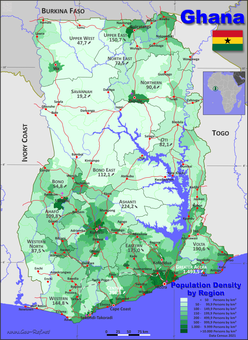
Ghana map - Click the map to get map as PDF file.
Other language versions are easy to generate, the descriptions are in own layers
Conditions for thematic maps with your own data and logotype
Delivery as printable file by e-mail or plot by post office
|
|---|
| Layers | |
| Provinces: | yes |
| Streets: | yes |
| Infrastructure: | yes |
| Rivers: | yes |
|
| Size | Till A2 |
| Delivery time | 7 working days | | Price |
| 1 bis 3 | 75 € | | > 3 | On request |
|
 |
All information published herein is free usable quoting the source,
including the maps, if they are not modified
|
|---|
Statistical data - Population density according to the administrative structure
The population data of the table below is census data from 2021, last available data.
Click on the column header brings the table in order of the column header.
The default order is the region name.
| Region |
ISO
3166-2 |
Capital |
Area
(km²) |
Population |
Density
(pers/km²) |
| Total |
|
|
230 492 |
30 832 019 |
133,8 |
|---|
| Last update: 01.10.2024 - 02:24:03 |
|---|
| Ahafo |
GH-AF |
Goaso |
5 141 |
564 668 |
109,8 |
| Ashanti |
GH-AH |
Kumasi |
24 270 |
5 440 463 |
224,2 |
| Bono |
GH-BO |
Sunyani |
21 952 |
1 203 400 |
54,8 |
| Bono East |
GH-BE |
Techiman |
10 778 |
1 208 649 |
112,1 |
| Central |
GH-CP |
Cape Coast |
9 634 |
2 859 821 |
296,8 |
| Eastern |
GH-EP |
Koforidua |
16 715 |
2 925 653 |
175,0 |
| Greater Accra |
GH-AA |
Accra |
3 653 |
5 455 692 |
1 493,5 |
| North East |
GH-NE |
Nalerigu |
9 092 |
658 946 |
72,5 |
| Northern |
GH-NP |
Tamale |
25 552 |
2 310 939 |
90,4 |
| Oti |
GH-OT |
Dambai |
9 104 |
747 248 |
82,1 |
| Savannah |
GH-SV |
Damongo |
34 093 |
653 266 |
19,2 |
| Upper East |
GH-UE |
Bolgatanga |
8 632 |
1 301 226 |
150,7 |
| Upper West |
GH-UW |
Wa |
18 881 |
901 502 |
47,7 |
| Volta |
GH-TV |
Ho |
8 703 |
1 659 040 |
190,6 |
| Western |
GH-WP |
Sekondi-Takoradi |
14 229 |
2 060 585 |
144,8 |
| Western North |
GH-WN |
Wiawso |
10 063 |
880 921 |
87,5 |
The regions are divided into districts, the data of which are shown in the table below
| District |
Own ID |
Region |
Capital
| Area
(km²) |
Population |
Density
(pers/km²) |
| Total |
|
|
|
230 492 |
30 832 019 |
133,8 |
|---|
| Last update: 01.10.2024 - 02:24:03 |
|---|
| Ablekuma Central |
AA-01 |
Greater Accra |
Lartebiokorshie |
10 |
169 145 |
16 914,5 |
| Ablekuma North |
AA-02 |
Greater Accra |
Darkuman |
12 |
159 208 |
13 267,3 |
| Ablekuma West |
AA-03 |
Greater Accra |
Dansoman |
12 |
153 490 |
12 790,8 |
| Abuakwa North |
EP-01 |
Eastern |
Kukurantumi |
212 |
91 297 |
430,6 |
| Abuakwa South |
EP-02 |
Eastern |
Kibi |
313 |
73 949 |
236,3 |
| Abura-Asebu-Kwamankese |
CP-01 |
Central |
Dunkwa |
386 |
124 465 |
322,4 |
| Accra Metropolitan |
AA-04 |
Greater Accra |
Accra |
23 |
284 124 |
12 353,2 |
| Achiase |
EP-03 |
Eastern |
Achiase |
505 |
56 348 |
111,6 |
| Ada East |
AA-05 |
Greater Accra |
Ada Foah |
269 |
76 411 |
284,1 |
| Ada West |
AA-06 |
Greater Accra |
Sege |
326 |
76 087 |
233,4 |
| Adaklu |
TV-01 |
Volta |
Adaklu Waya |
322 |
38 649 |
120,0 |
| Adansi Asokwa |
AH-01 |
Ashanti |
Adansi Asokwa |
623 |
71 844 |
115,3 |
| Adansi North |
AH-02 |
Ashanti |
Fomena |
230 |
54 155 |
235,5 |
| Adansi South |
AH-03 |
Ashanti |
New Edubiase |
767 |
85 200 |
111,1 |
| Adenta |
AA-07 |
Greater Accra |
Adenta |
79 |
237 546 |
3 006,9 |
| Afadzato South |
TV-02 |
Volta |
Ve-Golokuati |
500 |
73 146 |
146,3 |
| Afigya Kwabre North |
AH-04 |
Ashanti |
Boamang |
268 |
73 330 |
273,6 |
| Afigya Kwabre South |
AH-05 |
Ashanti |
Kodie |
160 |
234 667 |
1 466,7 |
| Agona East |
CP-02 |
Central |
Nsaba |
318 |
98 324 |
309,2 |
| Agona West |
CP-03 |
Central |
Swedru |
354 |
136 882 |
386,7 |
| Agotime Ziope |
TV-03 |
Volta |
Agotime Kpetoe |
791 |
39 553 |
50,0 |
| Ahafo Ano North |
AH-06 |
Ashanti |
Tepa |
614 |
92 742 |
151,0 |
| Ahafo Ano South East |
AH-07 |
Ashanti |
Adugyama |
550 |
63 468 |
115,4 |
| Ahafo Ano South West |
AH-08 |
Ashanti |
Mankranso |
649 |
65 770 |
101,3 |
| Ahanta West |
WP-01 |
Western |
Agona Nkwanta |
555 |
153 140 |
275,9 |
| Ajumako-Enyan-Essiam |
CP-04 |
Central |
Ajumako |
543 |
120 586 |
222,1 |
| Akatsi North |
TV-04 |
Volta |
Ave Dakpa |
316 |
32 541 |
103,0 |
| Akatsi South |
TV-05 |
Volta |
Akatsi |
519 |
92 494 |
178,2 |
| Akrofuom |
AH-09 |
Ashanti |
Akrofuom |
568 |
49 291 |
86,8 |
| Akuapim North |
EP-04 |
Eastern |
Akropong |
265 |
105 315 |
397,4 |
| Akwapim South |
EP-05 |
Eastern |
Aburi |
229 |
76 922 |
335,9 |
| Akyemansa |
EP-06 |
Eastern |
Ofoase |
611 |
91 038 |
149,0 |
| Amansie Central |
AH-10 |
Ashanti |
Jacobu |
848 |
93 052 |
109,7 |
| Amansie South |
AH-11 |
Ashanti |
Manso Adubia |
774 |
116 366 |
150,3 |
| Amansie West |
AH-12 |
Ashanti |
Manso Nkwanta |
458 |
109 416 |
238,9 |
| Anloga |
TV-06 |
Volta |
Anloga |
314 |
94 895 |
302,2 |
| Aowin |
WN-01 |
Western North |
Enchi |
2 603 |
129 721 |
49,8 |
| Asante Akim Central |
AH-13 |
Ashanti |
Konongo-Odumase |
298 |
91 673 |
307,6 |
| Asante Akim North |
AH-14 |
Ashanti |
Agogo |
1 089 |
85 788 |
78,8 |
| Asante Akim South |
AH-15 |
Ashanti |
Juaso |
1 152 |
123 633 |
107,3 |
| Asene Manso-Akroso |
EP-07 |
Eastern |
Manso |
420 |
77 498 |
184,5 |
| Ashaiman |
AA-08 |
Greater Accra |
Ashaiman |
20 |
208 060 |
10 403,0 |
| Asikuma-Odoben-Brakwa |
CP-05 |
Central |
Breman Asikuma |
725 |
126 993 |
175,2 |
| Asokore Mampong |
AH-16 |
Ashanti |
Asokore Mampong |
24 |
191 402 |
7 975,1 |
| Asokwa |
AH-17 |
Ashanti |
Asokwa |
25 |
125 642 |
5 025,7 |
| Assin Central |
CP-06 |
Central |
Nanton |
370 |
88 753 |
239,9 |
| Assin North |
CP-07 |
Central |
Assin Bereku |
624 |
80 539 |
129,1 |
| Assin South |
CP-08 |
Central |
Nsuaem-Kyekyewere |
1 110 |
105 995 |
95,5 |
| Asunafo North |
AF-01 |
Ahafo |
Goaso |
1 413 |
150 198 |
106,3 |
| Asunafo South |
AF-02 |
Ahafo |
Kukuom |
912 |
91 693 |
100,5 |
| Asuogyaman |
EP-08 |
Eastern |
Atimpoku |
469 |
101 256 |
215,9 |
| Asutifi North |
AF-03 |
Ahafo |
Kenyasi |
929 |
73 556 |
79,2 |
| Asutifi South |
AF-04 |
Ahafo |
Hwidiem |
574 |
68 394 |
119,2 |
| Atebubu-Amantin |
BE-01 |
Bono East |
Atebubu |
2 605 |
144 947 |
55,6 |
| Atiwa East |
EP-09 |
Eastern |
Anyinam |
490 |
64 647 |
131,9 |
| Atiwa West |
EP-10 |
Eastern |
Kwabeng |
661 |
61 219 |
92,6 |
| Atwima Kwanwoma |
AH-18 |
Ashanti |
Twedie |
263 |
234 846 |
893,0 |
| Atwima Mponua |
AH-19 |
Ashanti |
Nyinahin |
1 876 |
155 254 |
82,8 |
| Atwima Nwabiagya |
AH-20 |
Ashanti |
Nkawie |
288 |
161 893 |
562,1 |
| Atwima Nwabiagya North |
AH-21 |
Ashanti |
Barekese |
277 |
155 025 |
559,7 |
| Awutu Senya East |
CP-09 |
Central |
Kasoa |
62 |
236 527 |
3 815,0 |
| Awutu Senya West |
CP-10 |
Central |
Awutu Breku |
280 |
161 460 |
576,6 |
| Ayawaso Central |
AA-09 |
Greater Accra |
Kokomlemle |
7 |
94 831 |
13 547,3 |
| Ayawaso East |
AA-10 |
Greater Accra |
Nima |
4 |
53 004 |
13 251,0 |
| Ayawaso North |
AA-11 |
Greater Accra |
Accra New Town |
2 |
63 386 |
31 693,0 |
| Ayawaso West |
AA-12 |
Greater Accra |
Dzorwulu |
35 |
75 303 |
2 151,5 |
| Ayensuano |
EP-11 |
Eastern |
Coaltar |
486 |
94 594 |
194,6 |
| Banda |
BO-01 |
Bono |
Banda Ahenkro |
2073 |
28 179 |
13,6 |
| Bawku |
UE-01 |
Upper East |
Bawku |
250 |
119 458 |
477,8 |
| Bawku West |
UE-02 |
Upper East |
Zebilla |
1 070 |
144 189 |
134,8 |
| Bekwai |
AH-22 |
Ashanti |
Bekwai |
553 |
137 967 |
249,5 |
| Berekum East |
BO-02 |
Bono |
Berekum |
407 |
106 252 |
261,1 |
| Berekum West |
BO-03 |
Bono |
Jinijini |
465 |
49 464 |
106,4 |
| Bia East |
WN-02 |
Western North |
Adabokrom |
793 |
53 073 |
66,9 |
| Bia West |
WN-03 |
Western North |
Essam |
1 342 |
115 881 |
86,3 |
| Biakoye |
OT-01 |
Oti |
Nkonya |
763 |
71 827 |
94,1 |
| Bibiani-Anhwiaso-Bekwai |
WN-04 |
Western North |
Bibiani |
831 |
167 971 |
202,1 |
| Binduri |
UE-03 |
Upper East |
Binduri |
392 |
76 679 |
195,6 |
| Birim Central |
EP-12 |
Eastern |
Akim Oda |
123 |
76 302 |
620,3 |
| Birim North |
EP-13 |
Eastern |
New Abirim |
573 |
82 669 |
144,3 |
| Birim South |
EP-14 |
Eastern |
Akim Swedru |
232 |
35 654 |
153,7 |
| Bodi |
WN-05 |
Western North |
Bodi |
678 |
65 748 |
97,0 |
| Bole |
SV-01 |
Savannah |
Bole |
6 226 |
115 800 |
18,6 |
| Bolgatanga |
UE-04 |
Upper East |
Zuarungu |
71 |
139 864 |
1 969,9 |
| Bolgatanga East |
UE-05 |
Upper East |
Bolgatanga |
326 |
38 824 |
119,1 |
| Bongo |
UE-06 |
Upper East |
Bongo |
415 |
120 254 |
289,8 |
| Bosome Freho |
AH-23 |
Ashanti |
Asiwa |
577 |
62 259 |
107,9 |
| Bosomtwe |
AH-24 |
Ashanti |
Kuntanase |
398 |
165 180 |
415,0 |
| Builsa North |
UE-07 |
Upper East |
Sandema |
805 |
56 571 |
70,3 |
| Builsa South |
UE-08 |
Upper East |
Fumbisi |
1 259 |
36 575 |
29,1 |
| Bunkpurugu-Nyakpanduri |
NE-01 |
North East |
Bunkpurugu |
535 |
82 384 |
154,0 |
| Cape Coast Metropolitan |
CP-11 |
Central |
Cape Coast |
122 |
189 925 |
1 556,8 |
| Central Gonja |
SV-02 |
Savannah |
Buipe |
7 362 |
142 762 |
19,4 |
| Central Tongu |
TV-07 |
Volta |
Adidome |
677 |
83 803 |
123,8 |
| Chereponi |
NE-02 |
North East |
Chereponi |
1 391 |
87 176 |
62,7 |
| Daffiama-Bussie-Issa |
UW-01 |
Upper West |
Issa |
1 445 |
38 754 |
26,8 |
| Denkyembour |
EP-15 |
Eastern |
Akwatia |
433 |
77 029 |
177,9 |
| Dormaa Central |
BO-04 |
Bono |
Dormaa Ahenkro |
1210 |
112 702 |
93,1 |
| Dormaa East |
BO-05 |
Bono |
Wamfie |
541 |
67 899 |
125,5 |
| Dormaa West |
BO-06 |
Bono |
Nkrankwanta |
369 |
47 913 |
129,8 |
| East Gonja |
SV-03 |
Savannah |
Salaga |
3 608 |
117 755 |
32,6 |
| East Mamprusi |
NE-03 |
North East |
Gambaga |
1 776 |
188 006 |
105,9 |
| Effia-Kwesimintsim |
WP-02 |
Western |
Kwesimintsim |
51 |
173 975 |
3 411,3 |
| Effutu |
CP-12 |
Central |
Winneba |
80 |
107 798 |
1 347,5 |
| Ejisu |
AH-25 |
Ashanti |
Ejisu |
223 |
180 723 |
810,4 |
| Ejura-Sekyedumase |
AH-26 |
Ashanti |
Ejura |
1 327 |
137 672 |
103,7 |
| Ekumfi |
CP-13 |
Central |
Apam |
270 |
56 741 |
210,2 |
| Ellembelle |
WP-03 |
Western |
Nkroful |
1 000 |
120 893 |
120,9 |
| Fanteakwa North |
EP-16 |
Eastern |
Begoro |
648 |
56 987 |
87,9 |
| Fanteakwa South |
EP-17 |
Eastern |
Osino |
358 |
54 634 |
152,6 |
| Ga Central |
AA-13 |
Greater Accra |
Sowutuom |
53 |
332 232 |
6 268,5 |
| Ga East |
AA-14 |
Greater Accra |
Abokobi |
76 |
283 379 |
3 728,7 |
| Ga North |
AA-15 |
Greater Accra |
Ofankor |
53 |
235 292 |
4 439,5 |
| Ga South |
AA-16 |
Greater Accra |
Ngleshie Amanfro |
294 |
350 121 |
1 190,9 |
| Ga West |
AA-17 |
Greater Accra |
Amasaman |
250 |
314 299 |
1 257,2 |
| Garu |
UE-09 |
Upper East |
Garu |
660 |
71 774 |
108,7 |
| Gomoa Central |
CP-14 |
Central |
Afransi |
225 |
83 610 |
371,6 |
| Gomoa East |
CP-15 |
Central |
Potsin |
323 |
308 697 |
955,7 |
| Gomoa West |
CP-16 |
Central |
Essarkyir |
456 |
129 512 |
284,0 |
| Guan |
OT-02 |
Oti |
|
343 |
28 238 |
82,3 |
| Gushiegu |
NP-01 |
Northern |
Gushegu |
2 837 |
153 965 |
54,3 |
| Ho |
TV-08 |
Volta |
Ho |
573 |
180 420 |
314,9 |
| Ho West |
TV-09 |
Volta |
Dzolokpuita |
992 |
82 886 |
83,6 |
| Hohoe |
TV-10 |
Volta |
Hohoe |
358 |
114 472 |
319,8 |
| Jaman North |
BO-07 |
Bono |
Sampa |
860 |
117 909 |
137,1 |
| Jaman South |
BO-08 |
Bono |
Drobo |
725 |
108 388 |
149,5 |
| Jasikan |
OT-03 |
Oti |
Jasikan |
533 |
59 695 |
112,0 |
| Jirapa |
UW-02 |
Upper West |
Jirapa |
1 191 |
91 279 |
76,6 |
| Jomoro |
WP-04 |
Western |
Half Assini |
1 483 |
126 576 |
85,4 |
| Juaben |
AH-27 |
Ashanti |
Juaben |
372 |
63 929 |
171,9 |
| Juaboso |
WN-06 |
Western North |
Juaboso |
1 289 |
88 814 |
68,9 |
| Kadjebi |
OT-04 |
Oti |
Kadjebi |
701 |
73 959 |
105,5 |
| Karaga |
NP-02 |
Northern |
Karaga |
2 758 |
114 225 |
41,4 |
| Kassena Nankana |
UE-10 |
Upper East |
Navrongo |
736 |
99 895 |
135,7 |
| Kassena Nankana West |
UE-11 |
Upper East |
Paga |
901 |
90 735 |
100,7 |
| Keta |
TV-11 |
Volta |
Keta |
182 |
78 862 |
433,3 |
| Ketu North |
TV-12 |
Volta |
Dzodze |
451 |
114 846 |
254,6 |
| Ketu South |
TV-13 |
Volta |
Denu |
254 |
253 122 |
996,5 |
| Kintampo North |
BE-02 |
Bono East |
Kintampo |
4 922 |
139 508 |
28,3 |
| Kintampo South |
BE-03 |
Bono East |
Jema |
1 510 |
89 126 |
59,0 |
| Komenda-Edina-Eguafo-Abirem |
CP-17 |
Central |
Elmina |
459 |
166 017 |
361,7 |
| Korle-Klottey |
AA-18 |
Greater Accra |
Osu |
12 |
68 633 |
5 719,4 |
| Kpandai |
NP-03 |
Northern |
Kpandai |
1 877 |
126 213 |
67,2 |
| Kpando |
TV-14 |
Volta |
Kpando |
226 |
58 552 |
259,1 |
| Kpone Katamanso |
AA-19 |
Greater Accra |
Kpone |
237 |
417 334 |
1 760,9 |
| Krachi East |
OT-05 |
Oti |
Dambai |
1 467 |
110 435 |
75,3 |
| Krachi Nchumuru |
OT-06 |
Oti |
Chinderi |
969 |
79 934 |
82,5 |
| Krachi West |
OT-07 |
Oti |
Kete Krachi |
641 |
61 128 |
95,4 |
| Krowor |
AA-20 |
Greater Accra |
Nungua |
18 |
143 012 |
7 945,1 |
| Kumasi Metropolitan |
AH-28 |
Ashanti |
Kumasi |
68 |
443 981 |
6 529,1 |
| Kumbungu |
NP-04 |
Northern |
Kumbungu |
1 500 |
110 586 |
73,7 |
| Kwabre East |
AH-29 |
Ashanti |
Mamponteng |
124 |
296 814 |
2 393,7 |
| Kwadaso |
AH-30 |
Ashanti |
Kwadaso |
42 |
154 526 |
3 679,2 |
| Kwaebibirem |
EP-18 |
Eastern |
Kade |
811 |
121 698 |
150,1 |
| Kwahu Afram Plains North |
EP-19 |
Eastern |
Donkorkrom |
1 208 |
66 555 |
55,1 |
| Kwahu Afram Plains South |
EP-20 |
Eastern |
Tease |
2 608 |
74 002 |
28,4 |
| Kwahu East |
EP-21 |
Eastern |
Abetifi |
846 |
79 726 |
94,2 |
| Kwahu South |
EP-22 |
Eastern |
Mpraeso |
436 |
80 358 |
184,3 |
| Kwahu West |
EP-23 |
Eastern |
Nkawkaw |
431 |
145 429 |
337,4 |
| La Dade-Kotopon |
AA-21 |
Greater Accra |
La |
36 |
140 264 |
3 896,2 |
| La Nkwantanang Madina |
AA-22 |
Greater Accra |
Madina |
68 |
244 676 |
3 598,2 |
| Lambussie Karni |
UW-03 |
Upper West |
Lambussie |
820 |
51 118 |
62,3 |
| Lawra |
UW-04 |
Upper West |
Lawra |
525 |
58 433 |
111,3 |
| Ledzokuku |
AA-23 |
Greater Accra |
Teshie |
36 |
217 304 |
6 036,2 |
| Lower Manya Krobo |
EP-24 |
Eastern |
Odumase |
306 |
121 478 |
397,0 |
| Mampong |
AH-31 |
Ashanti |
Mampong |
671 |
116 632 |
173,8 |
| Mamprugu Moagduri |
NE-04 |
North East |
Yagaba |
2 155 |
68 746 |
31,9 |
| Mfantsiman |
CP-18 |
Central |
Saltpond |
314 |
168 905 |
537,9 |
| Mion |
NP-05 |
Northern |
Sang |
2 627 |
94 930 |
36,1 |
| Mpohor |
WP-05 |
Western |
Mpohor |
719 |
52 473 |
73,0 |
| Nabdam |
UE-12 |
Upper East |
Nangodi |
246 |
51 861 |
210,8 |
| Nadowli-Kaleo |
UW-05 |
Upper West |
Nadowli |
1 130 |
77 057 |
68,2 |
| Nandom |
UW-06 |
Upper West |
Nandom |
395 |
51 328 |
129,9 |
| Nanton |
NP-06 |
Northern |
Nanton |
693 |
50 767 |
73,3 |
| Nanumba North |
NP-07 |
Northern |
Bimbilla |
2 383 |
188 680 |
79,2 |
| Nanumba South |
NP-08 |
Northern |
Wulensi |
1 667 |
106 374 |
63,8 |
| New Juaben North |
EP-25 |
Eastern |
Effiduase |
118 |
93 201 |
789,8 |
| New Juaben South |
EP-26 |
Eastern |
Koforidua |
43 |
125 256 |
2 912,9 |
| Ningo Prampram |
AA-24 |
Greater Accra |
Prampram |
614 |
204 673 |
333,3 |
| Nkoranza North |
BE-04 |
Bono East |
Busunya |
1 394 |
56 468 |
40,5 |
| Nkoranza South |
BE-05 |
Bono East |
Nkoranza |
925 |
114 642 |
123,9 |
| Nkwanta North |
OT-08 |
Oti |
Kpassa |
1 243 |
126 096 |
101,4 |
| Nkwanta South |
OT-09 |
Oti |
Nkwanta |
2 444 |
135 936 |
55,6 |
| North Dayi |
TV-15 |
Volta |
Anfoega |
252 |
39 268 |
155,8 |
| North East Gonja |
SV-04 |
Savannah |
Kpalbe |
3 169 |
39 404 |
12,4 |
| North Gonja |
SV-05 |
Savannah |
Daboya |
4 871 |
61 432 |
12,6 |
| North Tongu |
TV-16 |
Volta |
Battor Dugame |
1 117 |
110 891 |
99,3 |
| Nsawam Adoagyiri |
EP-27 |
Eastern |
Nsawam |
175 |
155 597 |
889,1 |
| Nzema East |
WP-06 |
Western |
Axim |
1 025 |
94 621 |
92,3 |
| Obuasi |
AH-32 |
Ashanti |
Obuasi |
110 |
104 297 |
948,2 |
| Obuasi East |
AH-33 |
Ashanti |
Tutuka |
96 |
92 401 |
962,5 |
| Offinso |
AH-34 |
Ashanti |
Offinso |
589 |
137 272 |
233,1 |
| Offinso North |
AH-35 |
Ashanti |
Akomadan |
956 |
83 440 |
87,3 |
| Oforikrom |
AH-36 |
Ashanti |
Oforikrom |
49 |
213 126 |
4 349,5 |
| Okaikwei North |
AA-25 |
Greater Accra |
Tesano |
21 |
160 446 |
7 640,3 |
| Okere |
EP-28 |
Eastern |
Adukrom |
332 |
51 675 |
155,6 |
| Old Tafo |
AH-37 |
Ashanti |
Old Tafo |
6 |
114 368 |
19 061,3 |
| Prestea-Huni Valley |
WP-07 |
Western |
Bogoso |
1 791 |
229 301 |
128,0 |
| Pru East |
BE-06 |
Bono East |
Yeji |
1 178 |
101 545 |
86,2 |
| Pru West |
BE-07 |
Bono East |
Prang |
2 090 |
69 383 |
33,2 |
| Pusiga |
UE-13 |
Upper East |
Pusiga |
254 |
80 533 |
317,1 |
| Saboba |
NP-09 |
Northern |
Saboba |
1 746 |
95 683 |
54,8 |
| Sagnarigu |
NP-10 |
Northern |
Sagnarigu |
440 |
341 711 |
776,6 |
| Savelugu |
NP-11 |
Northern |
Savelugu |
1 550 |
122 888 |
79,3 |
| Sawla-Tuna-Kalba |
SV-06 |
Savannah |
Sawla |
4 165 |
112 664 |
27,1 |
| Sefwi Akontombra |
WN-07 |
Western North |
Akontombra |
1 157 |
70 225 |
60,7 |
| Sefwi Wiawso |
WN-08 |
Western North |
Wiawso |
992 |
151 220 |
152,4 |
| Sekondi Takoradi Metropolitan |
WP-08 |
Western |
Sekondi-Takoradi |
66 |
245 382 |
3 717,9 |
| Sekyere Afram Plains |
AH-38 |
Ashanti |
Drobonso |
3 420 |
32 640 |
9,5 |
| Sekyere Central |
AH-39 |
Ashanti |
Nsuta |
1 652 |
73 228 |
44,3 |
| Sekyere East |
AH-40 |
Ashanti |
Effiduase |
239 |
74 789 |
312,9 |
| Sekyere Kumawu |
AH-41 |
Ashanti |
Kumawu |
575 |
64 396 |
112,0 |
| Sekyere South |
AH-42 |
Ashanti |
Agona |
409 |
120 076 |
293,6 |
| Sene East |
BE-08 |
Bono East |
Kajaji |
3 345 |
72 081 |
21,5 |
| Sene West |
BE-09 |
Bono East |
Kwame Danso |
2 910 |
69 836 |
24,0 |
| Shai Osudoku |
AA-26 |
Greater Accra |
Dodowa |
942 |
105 610 |
112,1 |
| Shama |
WP-09 |
Western |
Shama |
200 |
117 224 |
586,1 |
| Sissala East |
UW-07 |
Upper West |
Tumu |
5 100 |
80 619 |
15,8 |
| Sissala West |
UW-08 |
Upper West |
Gwollu |
1 854 |
63 828 |
34,4 |
| South Dayi |
TV-17 |
Volta |
Kpeve |
236 |
57 526 |
243,8 |
| South Tongu |
TV-18 |
Volta |
Sogakofe |
623 |
113 114 |
181,6 |
| Suaman |
WN-09 |
Western North |
Dadieso |
378 |
38 268 |
101,2 |
| Suame |
AH-43 |
Ashanti |
Suame |
13 |
136 290 |
10 483,8 |
| Suhum |
EP-29 |
Eastern |
Suhum |
362 |
126 403 |
349,2 |
| Sunyani |
BO-09 |
Bono |
Sunyani |
132 |
193 595 |
1 466,6 |
| Sunyani West |
BO-10 |
Bono |
Odumase |
1031 |
136 022 |
131,9 |
| Tain |
BO-11 |
Bono |
Nsawkaw |
1898 |
115 568 |
60,9 |
| Talensi |
UE-14 |
Upper East |
Tongo |
845 |
87 021 |
103,0 |
| Tamale Metropolitan |
NP-12 |
Northern |
Tamale |
440 |
374 744 |
851,7 |
| Tano North |
AF-05 |
Ahafo |
Duayaw Nkwanta |
830 |
93 608 |
112,8 |
| Tano South |
AF-06 |
Ahafo |
Bechem |
483 |
87 219 |
180,6 |
| Tarkwa Nsuaem |
WP-10 |
Western |
Tarkwa |
955 |
218 664 |
229,0 |
| Tatale-Sangule |
NP-13 |
Northern |
Tatale |
1 095 |
74 805 |
68,3 |
| Techiman |
BE-10 |
Bono East |
Techiman |
648 |
243 335 |
375,5 |
| Techiman North |
BE-11 |
Bono East |
Tuobodom |
425 |
102 529 |
241,2 |
| Tema Metropolitan |
AA-27 |
Greater Accra |
Tema |
39 |
177 924 |
4 562,2 |
| Tema West |
AA-28 |
Greater Accra |
Tema Community 18 |
51 |
196 224 |
3 847,5 |
| Tempane |
UE-15 |
Upper East |
Tempane |
402 |
86 993 |
216,4 |
| Tolon |
NP-14 |
Northern |
Tolon |
1 311 |
118 101 |
90,1 |
| Twifo-Ati Morkwa |
CP-19 |
Central |
Twifo-Praso |
956 |
100 851 |
105,5 |
| Twifo-Heman-Lower Denkyira |
CP-20 |
Central |
Heman |
566 |
66 075 |
116,7 |
| Upper Denkyira East |
CP-21 |
Central |
Dunkwa-On-Offin |
514 |
110 141 |
214,3 |
| Upper Denkyira West |
CP-22 |
Central |
Diaso |
577 |
91 025 |
157,8 |
| Upper Manya Krobo |
EP-30 |
Eastern |
Asesewa |
671 |
70 676 |
105,3 |
| Upper West Akim |
EP-31 |
Eastern |
Adeiso |
353 |
93 391 |
264,6 |
| Wa |
UW-09 |
Upper West |
Wa |
597 |
200 672 |
336,1 |
| Wa East |
UW-10 |
Upper West |
Funsi |
4 335 |
91 457 |
21,1 |
| Wa West |
UW-11 |
Upper West |
Wechiau |
1 489 |
96 957 |
65,1 |
| Wassa Amenfi Central |
WP-11 |
Western |
Wassa Akropong |
1 643 |
119 117 |
72,5 |
| Wassa Amenfi East |
WP-12 |
Western |
Daboase |
1 729 |
179 696 |
103,9 |
| Wassa Amenfi West |
WP-13 |
Western |
Asankrangwa |
1 489 |
129 882 |
87,2 |
| Wassa East |
WP-14 |
Western |
Manso Amenfi |
1 523 |
99 641 |
65,4 |
| Weija-Gbawe |
AA-29 |
Greater Accra |
Weija |
54 |
213 674 |
3 956,9 |
| Wenchi |
BO-12 |
Bono |
Wenchi |
1067 |
124 758 |
116,9 |
| West Akim |
EP-32 |
Eastern |
Asamankese |
472 |
120 145 |
254,5 |
| West Gonja |
SV-07 |
Savannah |
Damongo |
4 692 |
63 449 |
13,5 |
| West Mamprusi |
NE-05 |
North East |
Walewale |
2 602 |
175 755 |
67,5 |
| Yendi |
NP-15 |
Northern |
Yendi |
1 529 |
154 421 |
101,0 |
| Yilo Krobo |
EP-33 |
Eastern |
Somanya |
515 |
122 705 |
238,3 |
| Yunyoo-Nasuan |
NE-06 |
North East |
Yunyoo |
633 |
56 879 |
89,9 |
| Zabzugu |
NP-16 |
Northern |
Zabzugu |
1 099 |
82 846 |
75,4 |
Existing thematic maps
|
External links change quickly - If you get a link error - Please inform us!
 |
Membership in international organisations and treaties
Expand list
Political Alliances
Regional Unions
Military alliances/Arms control
Law enforcement
Business Alliances
Fishery
Financial
Free Trade Area, Internal Market
Technical alliances
Transport
Cientific
Humanitarian Unions
Cultural Unions
|
|
If you have suggestions to include other information or you find missed links, please inform us!
Click here ... |
International Border disputes
Expand list
See also neighboring states
|
| |


