Independent State of Papua New Guinea
| Capital |
Currency | Government system |
|---|
| Port Moresby |
Kina (PGK) |
Constitutional hereditary monarchy |
| Official language | Region |
Population |
|---|
Hiri Motu
Tok Pisin
English |
Far East |
Census 2024
10 185 363 |
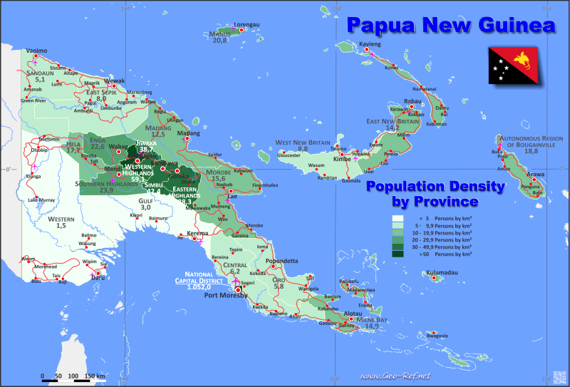
Country map - Administrative structure - Population density of Papua New Guinea
Papua New Guinea map - Click the map to get map as PDF file.
Other language versions are easy to generate, the descriptions are in own layers
Conditions for thematic maps with your own data and logotype
Delivery as printable file by e-mail or plot by post office
|
|---|
| Layers | |
| Provinces: | yes |
| Streets: | yes |
| Infrastructure: | yes |
| Rivers: | yes |
|
| Size | Till A2 |
| Delivery time | 7 working days | | Price |
| 1 bis 3 | 75 € | | > 3 | On request |
|
 |
All information published herein is free usable quoting the source,
including the maps, if they are not modified
|
|---|
Statistical data - Population density according to the administrative structure
The population data of the table below is census data from 2024, last available data.
Click on the column header brings the table in order of the column header.
The default order is the province name.
| Province |
ISO
3166-2 |
Capital |
Area
(km²) |
Population |
Density
(pers/km²) |
| Total |
|
|
462 085 |
10 185 363 |
22,0 |
|---|
| Last update: 01/02/2026 - 20:37:34 |
|---|
| Highlands |
PNG-1 |
Mount Hagen |
63 667 |
3 634 114 |
57,1 |
| Islands |
PNG-2 |
Arawa |
56 602 |
1 477 833 |
26,1 |
| Momase |
PNG-3 |
Lae |
141 837 |
2 753 211 |
19,4 |
| Papua |
PNG-4 |
Port Moresby |
199 979 |
2 320 205 |
11,6 |
The regions are subdivided into provinces, and their data can be found in the following table.shown in the next table.
| Province |
ISO
3166-2 |
Region |
Capital
| Area
(km²) |
Population |
Density
(pers/km²) |
| Total |
|
|
|
462 085 |
10 185 363 |
22,0 |
|---|
| Last update: 01/02/2026 - 20:37:34 |
|---|
| Autonomous Region of Bougainville |
PG-NSB |
Islands |
Buka |
9 384 |
367 093 |
39,1 |
| Central |
PG-CPM |
Papua |
Port Moresby |
29 998 |
373 779 |
12,5 |
| East New Britain |
PG-EBR |
Islands |
Kokopo |
15 274 |
434 757 |
28,5 |
| East Sepik |
PG-ESW |
Momase |
Wewak |
43 426 |
631 791 |
14,5 |
| Eastern Highlands |
PG-EHG |
Highlands |
Goroka |
11 157 |
800 072 |
71,7 |
| Enga |
PG-EPW |
Highlands |
Wabag |
11 704 |
489 971 |
41,9 |
| Gulf |
PG-GPK |
Papua |
Kerema |
34 472 |
203 545 |
5,9 |
| Hela |
PG-HLA |
Highlands |
Tari |
10 498 |
365 806 |
34,8 |
| Jiwaka |
PG-JWK |
Highlands |
Kurumul |
4 798 |
455 208 |
94,9 |
| Madang |
PG-MPM |
Momase |
Madang |
28 886 |
761 154 |
26,4 |
| Manus |
PG-MRL |
Islands |
Lorengau |
2 000 |
69 560 |
34,8 |
| Milne Bay |
PGMBA- |
Papua |
Alotau |
14 345 |
412 158 |
28,7 |
| Morobe |
PG-MPL |
Momase |
Lae |
33 705 |
997 545 |
29,6 |
| National Capital District |
PG-NCD |
Papua |
Port Moresby |
240 |
756 754 |
3 153,1 |
| New Ireland |
PG-NIK |
Islands |
Kavieng |
9 557 |
237 780 |
24,9 |
| Oro (Northern) |
PG-NPP |
Papua |
Popondetta |
22 735 |
273 950 |
12,0 |
| Sandaun (West Sepik) |
PG-SAN |
Momase |
Vanimo |
35 820 |
362 721 |
10,1 |
| Simbu (Chimbu) |
PG-CPK |
Highlands |
Kundiawa |
6 122 |
458 406 |
74,9 |
| Southern Highlands |
PG-SHM |
Highlands |
Mendi |
15 089 |
602 085 |
39,9 |
| West New Britain |
PG-WBK |
Islands |
Kimbe |
20 387 |
368 643 |
18,1 |
| Western |
PG-WPD |
Papua |
Daru |
98 189 |
300 019 |
3,1 |
| Western Highlands |
PG-WHM |
Highlands |
Mount Hagen |
4 299 |
462 566 |
107,6 |
Existing thematic maps
|
External links change quickly - If you get a link error - Please inform us!
 |
Membership in international organisations and treaties
Expand list
Political Alliances
Regional Unions
Military alliances/Arms control
Law enforcement
Business Alliances
Fishery
Financial
Free Trade Area, Internal Market
Technical alliances
Environment
Transport
Cientific
Humanitarian Unions
Cultural Unions
|
|
If you have suggestions to include other information or you find missed links, please inform us!
Click here ... |
International Border disputes
Expand list
See also neighboring states
|
| |


