Republic of Malawi
| Capital |
Currency | Government system |
|---|
| Lilongwe |
Kwacha (MWK) |
Presidential system |
| Official language | Region |
Population |
|---|
Chichewa
English |
Africa |
Estimation 2023
19 809 511 |
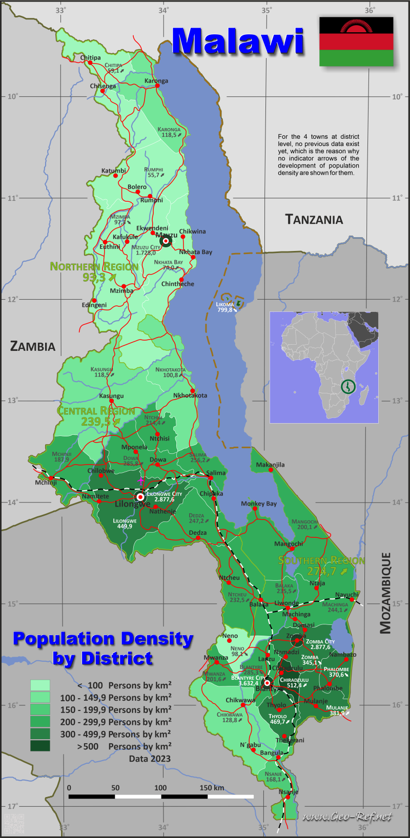
Country map - Administrative structure - Population density of Malawi
Malawi map - Click the map to get map as PDF file.
Other language versions are easy to generate, the descriptions are in own layers
Conditions for thematic maps with your own data and logotype
Delivery as printable file by e-mail or plot by post office
|
|---|
| Layers | |
| Provinces: | yes |
| Streets: | yes |
| Infrastructure: | yes |
| Rivers: | yes |
|
| Size | Till A2 |
| Delivery time | 7 working days | | Price |
| 1 bis 3 | 75 € | | > 3 | On request |
|
 |
All information published herein is free usable quoting the source,
including the maps, if they are not modified
|
|---|
Statistical data - Population density according to the administrative structure
The population data of the table below is an estimation form 2023, based on the census 2018.
Click on the column header brings the table in order of the column header.
The default order is the region name.
| Region |
ISO
3166-2 |
Capital |
Area
(km²) |
Population |
Density
(pers/km²) |
| Total |
|
|
94 593 |
19 809 511 |
209,4 |
|---|
| Last update: 17.01.2023 - 22:59:20 |
|---|
| Central |
MW-C |
Lilongwe |
35 639 |
8 533 879 |
239,5 |
| Northern |
MW-N |
Mzuzu City |
27 131 |
2 532 270 |
93,3 |
| Southern |
MW-S |
Blantyre |
31 823 |
8 743 362 |
274,7 |
In the next table, the regions are divided into districts.
| District |
HASC |
Region |
Capital
| Area
(km²) |
Population |
Density
(pers/km²) |
| Total |
|
|
|
94 593 |
19 809 511 |
209,4 |
|---|
| Last update: 17.01.2023 - 22:59:20 |
|---|
| Balaka |
MW-BA |
Southern |
Balaka |
2 142 |
504 349 |
235,5 |
| Blantyre |
MW-BL |
Southern |
Blantyre |
1 785 |
509 289 |
285,3 |
| Blantyre City |
- |
Southern |
Blantyre |
240 |
871 776 |
3 632,4 |
| Chikwawa |
MW-CK |
Southern |
Chikwawa |
4 878 |
628 282 |
128,8 |
| Chiradzulu |
MW-CR |
Southern |
Chiradzulu |
761 |
389 928 |
512,4 |
| Chitipa |
MW-CT |
Northern |
Chitipa |
4 334 |
256 197 |
59,1 |
| Dedza |
MW-DE |
Central |
Dedza |
3 754 |
928 094 |
247,2 |
| Dowa |
MW-DO |
Central |
Dowa |
3 077 |
879 386 |
285,8 |
| Karonga |
MW-KR |
Northern |
Karonga |
3 416 |
405 552 |
118,7 |
| Kasungu |
MW-KS |
Central |
Kasungu |
8 017 |
950 234 |
118,5 |
| Likoma |
MW-LK |
Northern |
Likoma |
20 |
15 995 |
799,8 |
| Lilongwe |
MW-LI |
Central |
Lilongwe |
5 807 |
1 830 619 |
315,2 |
| Lilongwe City |
- |
Central |
Lilongwe |
404 |
1 162 544 |
2 877,6 |
| Machinga |
MW-MH |
Southern |
Machinga |
3 582 |
874 337 |
244,1 |
| Mangochi |
MW-MG |
Southern |
Mangochi |
6 729 |
1 346 740 |
200,1 |
| Mchinji |
MW-MC |
Central |
Mchinji |
3 131 |
672 578 |
214,8 |
| Mulanje |
MW-MU |
Southern |
Mulanje |
2 005 |
765 623 |
381,9 |
| Mwanza |
MW-MW |
Southern |
Mwanza |
756 |
152 433 |
201,6 |
| Mzimba |
MW-MZ |
Northern |
Mzimba |
10 461 |
1 017 701 |
97,3 |
| Mzuzu City |
- |
Northern |
Mzuzu |
158 |
273 018 |
1 728,0 |
| Neno |
MW-NE |
Southern |
Neno |
1 561 |
153 132 |
98,1 |
| Nkhata Bay |
MW-NB |
Northern |
Nkhata Bay |
4 182 |
309 673 |
74,0 |
| Nkhotakota |
MW-NK |
Central |
Nkhotakota |
4 338 |
437 163 |
100,8 |
| Nsanje |
MW-NS |
Southern |
Nsanje |
1 945 |
326 874 |
168,1 |
| Ntcheu |
MW-NU |
Central |
Ntcheu |
3 251 |
755 748 |
232,5 |
| Ntchisi |
MW-NI |
Central |
Ntchisi |
1 709 |
366 491 |
214,4 |
| Phalombe |
MW-PH |
Southern |
Phalombe |
1 323 |
490 345 |
370,6 |
| Rumphi |
MW-RU |
Northern |
Rumphi |
4 560 |
254 134 |
55,7 |
| Salima |
MW-SA |
Central |
Salima |
2 151 |
551 022 |
256,2 |
| Thyolo |
MW-TH |
Southern |
Thyolo |
1 666 |
782 442 |
469,7 |
| Zomba |
MW-ZO |
Southern |
Zomba |
2 408 |
831 015 |
345,1 |
| Zomba City |
- |
Southern |
Zomba |
42 |
116 797 |
2 780,9 |
Existing thematic maps
|
External links change quickly - If you get a link error - Please inform us!
 |
Membership in international organisations and treaties
Expand list
Political Alliances
Regional Unions
Military alliances/Arms control
Law enforcement
Business Alliances
Financial
Free Trade Area, Internal Market
Technical alliances
Transport
Cientific
Humanitarian Unions
Cultural Unions
|
|
If you have suggestions to include other information or you find missed links, please inform us!
Click here ... |
International Border disputes
Expand list
See also neighboring states
|
| |


