Republic of the Union of Myanmar
| Capital |
Currency | Government system |
|---|
| Naypyidaw |
Kyat (MMK) |
Parliamentary democracy |
| Official language | Region |
Population |
|---|
| Burmese |
Far East |
Census 2024
51 316 756 |
Country map - Administrative structure - Population density of Myanmar
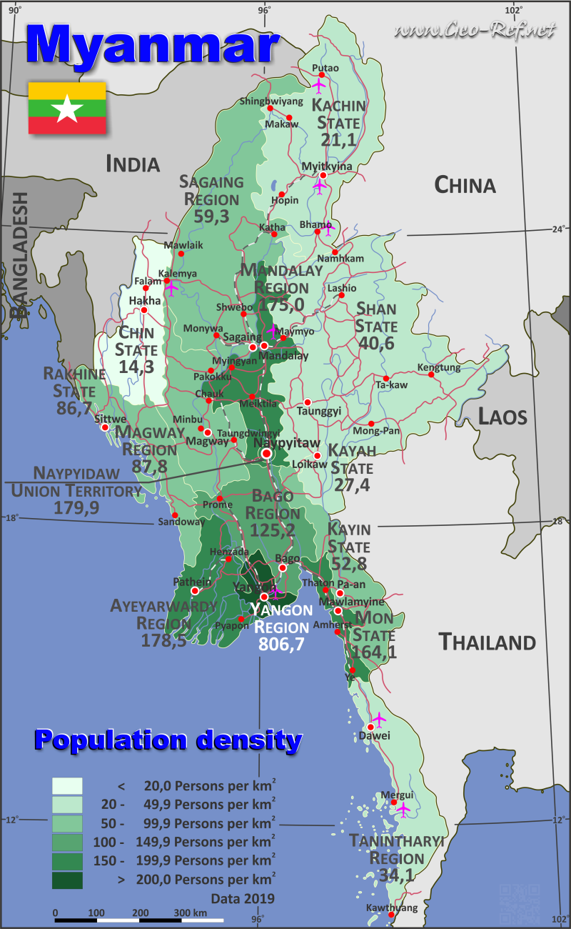
Myanmar map - Click the map to get map as PDF file.
Other language versions are easy to generate, the descriptions are in own layers
Conditions for thematic maps with your own data and logotype
Delivery as printable file by e-mail or plot by post office
|
|---|
| Layers | |
| Provinces: | yes |
| Streets: | yes |
| Infrastructure: | yes |
| Rivers: | yes |
|
| Size | Till A2 |
| Delivery time | 7 working days | | Price |
| 1 bis 3 | 65 € | | > 3 | On request |
|
 |
All information published herein is free usable quoting the source,
including the maps, if they are not modified
|
|---|
Statistical data - Population density according to the administrative structure
The population data of the table below is census data from 2024, last available data.
Click on the column header brings the table in order of the column header.
The default order is the region/state name.
| Region/State |
ISO
3166-2 |
Region |
Capital |
Area
(km²) |
Population |
Density
(pers/km²) |
| Total |
|
|
|
667 589 |
51 316 756 |
76,9 |
|---|
| Last update: 01.06.2025 - 19:53:35 |
|---|
| Ayeyarwady Region |
MM-07 |
Lower |
Pathein |
32 621 |
5 546 281 |
170,0 |
| Bago Region |
MM-02 |
Lower |
Bago |
38 496 |
4 453 691 |
115,7 |
| Chin State |
MM-14 |
West |
Hakha |
36 017 |
373 024 |
10,4 |
| Kachin State |
MM-11 |
North |
Myitkyina |
88 978 |
2 197 283 |
24,7 |
| Kayah State |
MM-12 |
East |
Loikaw |
11 763 |
296 903 |
25,2 |
| Kayin State |
MM-13 |
South |
Pa-an |
30 347 |
1 490 968 |
49,1 |
| Magway Region |
MM-03 |
Central |
Magwe |
44 846 |
4 078 504 |
90,9 |
| Mandalay Region |
MM-04 |
Central |
Mandalay |
30 944 |
6 283 663 |
203,1 |
| Mon State |
MM-15 |
South |
Mawlamyaing |
11 446 |
1 717 166 |
150,0 |
| Naypyidaw Union Territory |
MM-18 |
Central |
Naypyidaw |
7 058 |
1 129 344 |
160,0 |
| Rakhine State |
MM-16 |
West |
Sittwe |
34 768 |
2 466 385 |
70,9 |
| Sagaing Region |
MM-01 |
North |
Sagaing |
93 618 |
6 015 590 |
64,3 |
| Shan State |
MM-17 |
East |
Taunggyi |
155 693 |
6 517 377 |
41,9 |
| Tanintharyi Region |
MM-05 |
South |
Dawei |
41 126 |
1 380 567 |
33,6 |
| Yangon Region |
MM-06 |
Lower |
Yangon |
9 868 |
7 370 010 |
746,9 |
The regions are divided into districts, the data of which are shown in the table below.
| District |
Own |
Area |
Capital
| Area
(km²) |
Population |
Density
(pers/km²) |
| Total |
|
|
|
667 589 |
51 316 756 |
76,9 |
|---|
| Last update: 01.06.2025 - 19:53:35 |
|---|
| Ahlon |
MM-06-01 |
Yangon |
Yangon |
17 |
229 600 |
13 505,9 |
| Amarapura |
MM-04-01 |
Mandalay |
Amarapura |
209 |
249 883 |
1 195,6 |
| Ann |
MM-16-01 |
Rakhine |
Ann |
6 273 |
121 199 |
19,3 |
| Aunglan |
MM-03-01 |
Magway |
Aunglan |
4 731 |
387 555 |
81,9 |
| Aungmyethazan |
MM-04-02 |
Mandalay |
Aungmyethazan |
1 716 |
792 084 |
461,6 |
| Bago |
MM-02-01 |
Bago |
Bago |
5 666 |
927 389 |
163,7 |
| Bawlakhe |
MM-12-01 |
Kayah |
Bawlakhe |
3 376 |
38 855 |
11,5 |
| Bhamo |
MM-11-01 |
Kachin |
Bhamo |
10 825 |
620 200 |
57,3 |
| Bokpyin |
MM-05-01 |
Tanintharyi |
Bokpyin |
5 832 |
82 752 |
14,2 |
| Botahtaung |
MM-06-02 |
Yangon |
Yangon |
26 |
469 495 |
18 057,5 |
| Chauk |
MM-03-02 |
Magway |
Chauk |
2 023 |
357 742 |
176,8 |
| Chipwi |
MM-11-02 |
Kachin |
Chipwi |
6 724 |
43 841 |
6,5 |
| Dagon Myothit |
MM-06-03 |
Yangon |
Yangon |
275 |
1 044 449 |
3 798,0 |
| Danu |
MM-17-01 |
Shan |
Pindaya |
3 610 |
170 099 |
47,1 |
| Dawei |
MM-05-02 |
Tanintharyi |
Dawei |
13 784 |
499 084 |
36,2 |
| Demoso |
MM-12-02 |
Kayah |
Demoso |
2 860 |
119 832 |
41,9 |
| Falam |
MM-14-01 |
Chin |
Falam |
2 667 |
19 591 |
7,3 |
| Gangaw |
MM-03-03 |
Magway |
Gangaw |
5 577 |
269 853 |
48,4 |
| Hakha |
MM-14-02 |
Chin |
Hakha |
7 732 |
98 497 |
12,7 |
| Hinthada |
MM-07-01 |
Ayeyarwady |
Hinthada |
2 643 |
560 956 |
212,2 |
| Hkamti |
MM-01-01 |
Sagaing |
Hkamti |
8 174 |
41 413 |
5,1 |
| Hlegu |
MM-06-04 |
Yangon |
Hlegu |
1 508 |
327 032 |
216,9 |
| Hmawbi |
MM-06-05 |
Yangon |
Hmawbi |
1 083 |
521 453 |
481,5 |
| Homalin |
MM-01-02 |
Sagaing |
Homalin |
10 639 |
295 396 |
27,8 |
| Hopang |
MM-17-02 |
Shan |
Hopang |
4 621 |
228 074 |
49,4 |
| Hpa-An |
MM-13-01 |
Kayin |
Hpa-An |
7 229 |
730 200 |
101,0 |
| Hpapun |
MM-13-02 |
Kayin |
Hpapun |
6 731 |
118 834 |
17,7 |
| Insein |
MM-06-06 |
Yangon |
Insein |
104 |
906 512 |
8 716,5 |
| Kalaw |
MM-17-03 |
Shan |
Kalaw |
5 005 |
617 586 |
123,4 |
| Kale |
MM-01-03 |
Sagaing |
Kalay |
8 627 |
703 241 |
81,5 |
| Kamayut |
MM-06-07 |
Yangon |
Kamayut |
15 |
158 895 |
10 593,0 |
| Kanbalu |
MM-01-04 |
Sagaing |
Kanbalu |
6 816 |
412 478 |
60,5 |
| Katha |
MM-01-05 |
Sagaing |
Katha |
9 372 |
681 962 |
72,8 |
| Kawkareik |
MM-13-03 |
Kayin |
Kawkareik |
2 417 |
139 683 |
57,8 |
| Kawlin |
MM-01-06 |
Sagaing |
Kawlin |
6 490 |
369 361 |
56,9 |
| Kawthaung |
MM-05-03 |
Tanintharyi |
Kawthaung |
2 542 |
97 339 |
38,3 |
| Kengtung |
MM-17-04 |
Shan |
Kengtung |
12 654 |
254 800 |
20,1 |
| Kokang |
MM-17-05 |
Shan |
Laukkai |
1 845 |
248 407 |
134,6 |
| Kutkai |
MM-17-06 |
Shan |
Kutkai |
4 540 |
171 105 |
37,7 |
| Kyaikto |
MM-15-01 |
Mon |
Kyaikto |
3 021 |
296 888 |
98,3 |
| Kyainseikgyi |
MM-13-04 |
Kayin |
Kyainseikgyi |
7 197 |
245 303 |
34,1 |
| Kyaukme |
MM-17-07 |
Shan |
Kyaukme |
13 965 |
709 692 |
50,8 |
| Kyaukpyu |
MM-16-02 |
Rakhine |
Kyaukpyu |
2 317 |
229 213 |
98,9 |
| Kyaukse |
MM-04-03 |
Mandalay |
Kyaukse |
3 211 |
563 251 |
175,4 |
| Kyauktada |
MM-06-08 |
Yangon |
Kyauktada |
9 |
128 172 |
14 241,3 |
| Kyonpyaw |
MM-07-02 |
Ayeyarwady |
Kyonpyaw |
2 803 |
562 958 |
200,8 |
| Labutta |
MM-07-03 |
Ayeyarwady |
Labutta |
3 729 |
549 780 |
147,4 |
| Langkho |
MM-17-08 |
Shan |
Langkho |
8 987 |
93 015 |
10,3 |
| Lashio |
MM-17-09 |
Shan |
Lashio |
6 257 |
470 315 |
75,2 |
| Lewe |
MM-18-01 |
Naypyitaw |
Lewe |
2 302 |
312 627 |
135,8 |
| Loikaw |
MM-12-03 |
Kayah |
Loikaw |
3 717 |
126 411 |
34,0 |
| Loilem |
MM-17-10 |
Shan |
Loilem |
7 901 |
175 498 |
22,2 |
| Magway |
MM-03-04 |
Magway |
Magway |
7 633 |
892 173 |
116,9 |
| Mahaaungmyay |
MM-04-04 |
Mandalay |
Mahaaungmyay |
85 |
832 708 |
9 796,6 |
| Matman |
MM-17-11 |
Shan |
Matman |
9 794 |
209 547 |
21,4 |
| Matupi |
MM-14-03 |
Chin |
Matupi |
5 903 |
45 693 |
7,7 |
| Maubin |
MM-07-04 |
Ayeyarwady |
Maubin |
4 294 |
926 269 |
215,7 |
| Maungdaw |
MM-16-03 |
Rakhine |
Maungdaw |
3 696 |
264 498 |
71,6 |
| Mawlaik |
MM-01-07 |
Sagaing |
Mawlaik |
7 666 |
211 681 |
27,6 |
| Mawlamyine |
MM-15-02 |
Mon |
Mawlamyine |
3 418 |
794 384 |
232,4 |
| Mayangon |
MM-06-09 |
Yangon |
Mayangon |
62 |
606 836 |
9 787,7 |
| Meiktila |
MM-04-05 |
Mandalay |
Meiktila |
5 779 |
814 620 |
141,0 |
| Mese |
MM-12-04 |
Kayah |
Mese |
1 810 |
11 805 |
6,5 |
| Minbu |
MM-03-05 |
Magway |
Minbu |
9 304 |
690 045 |
74,2 |
| Mindat |
MM-14-04 |
Chin |
Mindat |
5 753 |
60 941 |
10,6 |
| Mingaladon |
MM-06-10 |
Yangon |
Mingaladon |
186 |
793 250 |
4 264,8 |
| Mohnyin |
MM-11-03 |
Kachin |
Mohnyin |
15 401 |
721 602 |
46,9 |
| Monghsat |
MM-17-12 |
Shan |
Monghsat |
5 001 |
90 055 |
18,0 |
| Monghsu |
MM-17-13 |
Shan |
Monghsu |
5 384 |
131 420 |
24,4 |
| Mongla |
MM-17-14 |
Shan |
Mongla |
1 842 |
50 637 |
27,5 |
| Mongmit |
MM-17-15 |
Shan |
Momeik |
7 733 |
135 581 |
17,5 |
| Mongton |
MM-17-16 |
Shan |
Mongton |
6 527 |
85 457 |
13,1 |
| Mongyang |
MM-17-17 |
Shan |
Mongyang |
2 917 |
117 108 |
40,1 |
| Mongyawng |
MM-17-18 |
Shan |
Mongyawng |
4 382 |
93 320 |
21,3 |
| Monywa |
MM-01-08 |
Sagaing |
Monywa |
3 480 |
608 592 |
174,9 |
| Mrauk-U |
MM-16-04 |
Rakhine |
Mrauk-U |
8 342 |
808 737 |
96,9 |
| Muse |
MM-17-19 |
Shan |
Muse |
3 121 |
377 450 |
120,9 |
| Myanaung |
MM-07-05 |
Ayeyarwady |
Myanaung |
4 364 |
469 281 |
107,5 |
| Myaungmya |
MM-07-06 |
Ayeyarwady |
Myaungmya |
3 063 |
717 198 |
234,1 |
| Myawaddy |
MM-13-05 |
Kayin |
Myawaddy |
3 140 |
168 779 |
53,8 |
| Myeik |
MM-05-04 |
Tanintharyi |
Myeik |
18 968 |
701 392 |
37,0 |
| Myingyan |
MM-04-06 |
Mandalay |
Myingyan |
3 588 |
736 445 |
205,3 |
| Myitkyina |
MM-11-04 |
Kachin |
Myitkyina |
15 956 |
562 469 |
35,3 |
| Naga |
MM-01-09 |
Sagaing |
Lahe |
13 330 |
121 682 |
9,1 |
| Namphan |
MM-17-20 |
Shan |
Namphan |
7 647 |
187 717 |
24,5 |
| Nattalin |
MM-02-02 |
Bago |
Nattalin |
3 320 |
432 535 |
130,3 |
| Nyaunglebin |
MM-02-03 |
Bago |
Nyaunglebin |
9 320 |
866 566 |
93,0 |
| Nyaung-U |
MM-04-07 |
Mandalay |
Nyaung-U |
3 413 |
482 045 |
141,2 |
| Ottara |
MM-18-02 |
Naypyitaw |
Ottara |
2 779 |
270 917 |
97,5 |
| Pakokku |
MM-03-06 |
Magway |
Pakokku |
8 310 |
1 149 879 |
138,4 |
| Palaung |
MM-17-21 |
Shan |
Namhsan |
4 108 |
135 957 |
33,1 |
| Paletwa |
MM-14-05 |
Chin |
Paletwa |
8 079 |
83 905 |
10,4 |
| Pa-O |
MM-17-22 |
Shan |
Hopong |
8 371 |
495 224 |
59,2 |
| Pathein |
MM-07-07 |
Ayeyarwady |
Pathein |
7 649 |
903 051 |
118,1 |
| Putao |
MM-11-05 |
Kachin |
Putao |
27 732 |
112 517 |
4,1 |
| Pyapon |
MM-07-08 |
Ayeyarwady |
Pyapon |
4 076 |
856 788 |
210,2 |
| Pyay |
MM-02-04 |
Bago |
Pyay |
5 901 |
564 391 |
95,6 |
| Pyinmana |
MM-18-03 |
Naypyitaw |
Pyinmana |
1 185 |
298 113 |
251,6 |
| Pyinoolwin |
MM-04-08 |
Mandalay |
Pyin U Lwin |
1 990 |
361 096 |
181,5 |
| Sagaing |
MM-01-10 |
Sagaing |
Sagaing |
2 449 |
522 159 |
213,2 |
| Shwebo |
MM-01-11 |
Sagaing |
Shwebo |
3 417 |
808 294 |
236,6 |
| Sittwe |
MM-16-05 |
Rakhine |
Sittwe |
3 122 |
699 772 |
224,1 |
| Tachileik |
MM-17-23 |
Shan |
Tachileik |
5 101 |
255 917 |
50,2 |
| Tada-U |
MM-04-09 |
Mandalay |
Tada-U |
1 897 |
344 511 |
181,6 |
| Taikkyi |
MM-06-11 |
Yangon |
Taikkyi |
1 763 |
272 238 |
154,4 |
| Tamu |
MM-01-12 |
Sagaing |
Tamu |
1 951 |
106 127 |
54,4 |
| Tanai |
MM-11-06 |
Kachin |
Tanai |
12 340 |
136 654 |
11,1 |
| Tangyan |
MM-17-24 |
Shan |
Tangyan |
7 239 |
329 542 |
45,5 |
| Taunggyi |
MM-17-25 |
Shan |
Taunggyi |
7 141 |
683 854 |
95,8 |
| Taungoo |
MM-02-05 |
Bago |
Taungoo |
8 631 |
954 714 |
110,6 |
| Tedim |
MM-14-06 |
Chin |
Tedim |
5 883 |
64 397 |
10,9 |
| Thabeikkyin |
MM-04-10 |
Mandalay |
Thabeikkyin |
5 262 |
604 995 |
115,0 |
| Thandaunggyi |
MM-13-06 |
Kayin |
Thandaunggyi |
3 633 |
88 169 |
24,3 |
| Thandwe |
MM-16-06 |
Rakhine |
Thandwe |
5 750 |
208 676 |
36,3 |
| Thanlyin |
MM-06-12 |
Yangon |
Thanlyin |
2 606 |
745 806 |
286,2 |
| Thaton |
MM-15-03 |
Mon |
Thaton |
2 278 |
379 654 |
166,7 |
| Thayarwady |
MM-02-06 |
Bago |
Thayarwady |
5 658 |
708 096 |
125,1 |
| Thayet |
MM-03-07 |
Magway |
Thayet |
7 268 |
331 257 |
45,6 |
| Thingangyun |
MM-06-13 |
Yangon |
Yangon |
31 |
575 032 |
18 549,4 |
| Toungup |
MM-16-07 |
Rakhine |
Toungup |
5 268 |
134 290 |
25,5 |
| Twantay |
MM-06-14 |
Yangon |
Twantay |
2 183 |
591 240 |
270,8 |
| Yamethin |
MM-04-11 |
Mandalay |
Yamethin |
3 794 |
502 025 |
132,3 |
| Ye |
MM-15-04 |
Mon |
Ye |
2 729 |
246 240 |
90,2 |
| Ye-U |
MM-01-13 |
Sagaing |
Ye-U |
4 627 |
537 978 |
116,3 |
| Yinmabin |
MM-01-14 |
Sagaing |
Yinmabin |
6 580 |
595 226 |
90,5 |
| Zeyarthiri |
MM-18-04 |
Naypyitaw |
Zeyarthiri |
792 |
247 687 |
312,7 |
Existing thematic maps
|
External links change quickly - If you get a link error - Please inform us!
 |
Membership in international organisations and treaties
Expand list
Political Alliances
Regional Unions
Military alliances/Arms control
Law enforcement
Business Alliances
Fishery
Financial
Free Trade Area, Internal Market
Technical alliances
Transport
Cientific
Humanitarian Unions
Cultural Unions
|
|
If you have suggestions to include other information or you find missed links, please inform us!
Click here ... |
International Border disputes
Expand list
See also neighboring states
|
| |


