Gabonese Republic
Country map - Administrative structure - Population density of Gabon
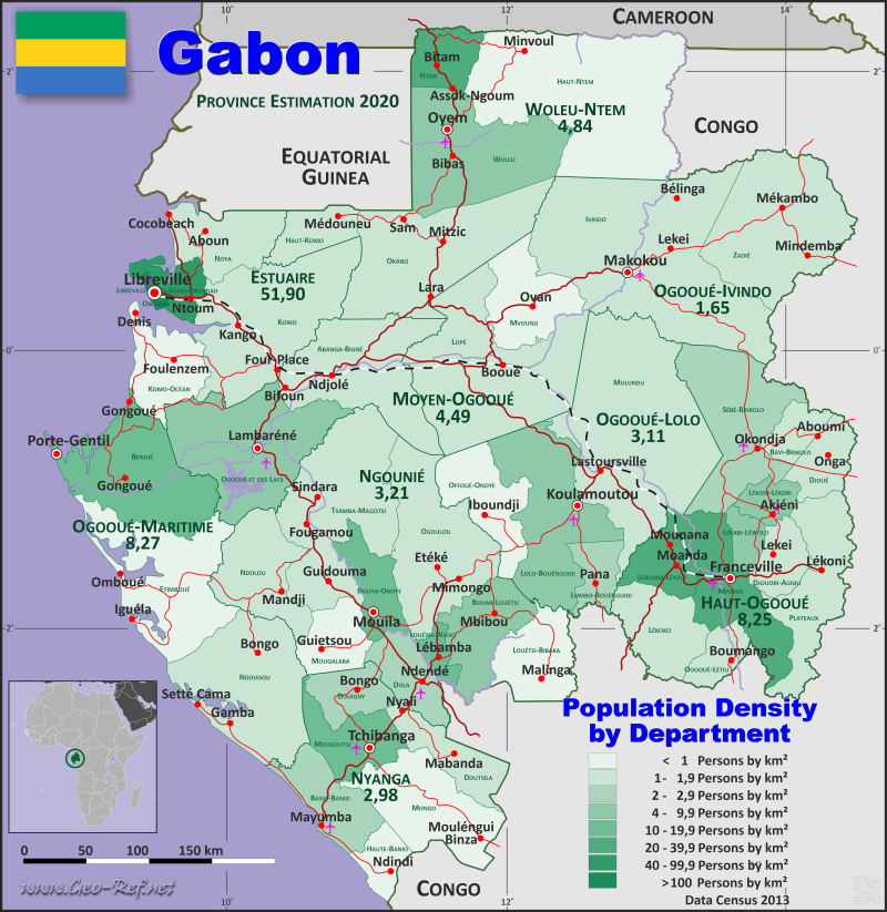
Gabon map - Click the map to get map as PDF file.
Other language versions are easy to generate, the descriptions are in own layers
Conditions for thematic maps with your own data and logotype
Delivery as printable file by e-mail or plot by post office
|
|---|
| Layers | |
| Provinces: | yes |
| Streets: | yes |
| Infrastructure: | yes |
| Rivers: | yes |
|
| Size | Till A2 |
| Delivery time | 7 working days | | Price |
| 1 bis 3 | 75 € | | > 3 | On request |
|
 |
All information published herein is free usable quoting the source,
including the maps, if they are not modified
|
|---|
Statistical data - Population density according to the administrative structure
The population data of the table below is an estimation form 2020, based on the census 2013.
Click on the column header brings the table in order of the column header.
The default order is the province name.
| Province |
ISO
3166-2 |
Capital |
Area
(km²) |
Population |
Density
(pers/km²) |
| Total |
|
|
267 667 |
2 176 700 |
8,1 |
|---|
| Last update: 11/04/202 - 00:44:02 |
|---|
| Estuaire |
GA-1 |
Libreville |
20 740 |
1 076 500 |
51,9 |
| Haut-Ogooué |
GA-2 |
Franceville |
36 547 |
301 400 |
8,2 |
| Moyen-Ogooué |
GA-3 |
Lambaréné |
18 535 |
83 300 |
4,5 |
| Ngounié |
GA-4 |
Mouila |
37 750 |
121 200 |
3,2 |
| Nyanga |
GA-5 |
Tchibanga |
21 285 |
63 500 |
3,0 |
| Ogooué-Ivindo |
GA-6 |
Makokou |
46 075 |
76 100 |
1,7 |
| Ogooué-Lolo |
GA-7 |
Koulamoutou |
25 380 |
79 000 |
3,1 |
| Ogooué-Maritime |
GA-8 |
Port-Gentil |
22 890 |
189 400 |
8,3 |
| Woleu-Ntem |
GA-9 |
Oyem |
38 465 |
186 300 |
4,8 |
The provinces are divided into departments , the data of which are shown in the table below. Observe, the Province data is estimated for 2020, the department data is Census result 2013.
| Department |
Own |
Province |
Capital
| Area
(km²) |
Population |
Density
(pers/km²) |
| Total |
|
|
|
265 389 |
1 811 079 |
6,8 |
|---|
| Last update: 11/04/202 - 00:44:02 |
|---|
| Abanga-Bigné |
GA-3-01 |
Moyen-Ogooué |
Lambaréné |
8 030 |
14 941 |
1,9 |
| Basse-Banio |
GA-5-01 |
Nyanga |
Mayumba |
3 373 |
7 192 |
2,1 |
| Bayi-Brikolo |
GA-2-01 |
Haut-Ogooué |
Aboumi |
1 559 |
1 998 |
1,3 |
| Bendjé |
GA-8-01 |
Ogooué-Maritime |
Port-Gentil |
7 475 |
140 747 |
18,8 |
| Boumi-Louétsi |
GA-4-01 |
Ngounié |
Mbigou |
3 901 |
13 223 |
3,4 |
| Djoué |
GA-2-02 |
Haut-Ogooué |
Onga |
2 226 |
2 178 |
1,0 |
| Djouori-Agnili |
GA-2-03 |
Haut-Ogooué |
Bongoville |
2 169 |
4 210 |
1,9 |
| Dola |
GA-4-02 |
Ngounié |
Ndendé |
2 647 |
6 979 |
2,6 |
| Douigny |
GA-5-02 |
Nyanga |
Moabi |
2 297 |
5 235 |
2,3 |
| Doutsila |
GA-5-03 |
Nyanga |
Mabanda |
2 834 |
4 623 |
1,6 |
| Douya-Onoye |
GA-4-03 |
Ngounié |
Mouila |
2 523 |
37 699 |
14,9 |
| Etimboué |
GA-8-02 |
Ogooué-Maritime |
Omboué |
8 597 |
5 723 |
0,7 |
| Haut-Komo |
GA-9-01 |
Woleu-Ntem |
Médouneu |
2 166 |
3 403 |
1,6 |
| Haut-Ntem |
GA-9-02 |
Woleu-Ntem |
Minvoul |
15 025 |
10 838 |
0,7 |
| Haute-Banio |
GA-5-04 |
Nyanga |
Ndindi |
1 541 |
1 413 |
0,9 |
| Ivindo |
GA-6-01 |
Ogooué-Ivindo |
Makokou |
17 962 |
31 073 |
1,7 |
| Komo |
GA-1-01 |
Estuaire |
Kango |
9 928 |
17 575 |
1,8 |
| Komo-Mondah |
GA-1-02 |
Estuaire |
Ntoum |
1 842 |
90 096 |
48,9 |
| Komo-Océan |
GA-1-03 |
Estuaire |
Ndzomoe |
3 646 |
553 |
0,2 |
| Lébombi-Léyou |
GA-2-04 |
Haut-Ogooué |
Moanda |
2 601 |
64 569 |
24,8 |
| Lékabi-Léwolo |
GA-2-05 |
Haut-Ogooué |
Ngouoni |
1 111 |
4 914 |
4,4 |
| Lékoko |
GA-2-06 |
Haut-Ogooué |
Bakoumba |
3 936 |
4 920 |
1,3 |
| Lékoni-Lékori |
GA-2-07 |
Haut-Ogooué |
Akieni |
1 322 |
10 028 |
7,6 |
| Libreville |
GA-1-04 |
Estuaire |
Libreville |
189 |
703 940 |
3 724,6 |
| Lolo-Bouénguidi |
GA-7-01 |
Ogooué-Lolo |
Koulamoutou |
7 818 |
30 643 |
3,9 |
| Lombo-Bouénguidi |
GA-7-02 |
Ogooué-Lolo |
Pana |
1 699 |
4 635 |
2,7 |
| Lopé |
GA-6-02 |
Ogooué-Ivindo |
Booué |
11 963 |
12 382 |
1,0 |
| Louétsi-Bibaka |
GA-4-04 |
Ngounié |
Malinga |
3 764 |
2 734 |
0,7 |
| Louétsi-Wano |
GA-4-05 |
Ngounié |
Lébamba |
890 |
9 750 |
11,0 |
| Mongo |
GA-5-05 |
Nyanga |
Moulengui-Binza |
6 100 |
2 602 |
0,4 |
| Mougalaba |
GA-4-06 |
Ngounié |
Guiétsou |
2 553 |
1 490 |
0,6 |
| Mougoutsi |
GA-5-06 |
Nyanga |
Tchibanga |
3 109 |
31 789 |
10,2 |
| Mpassa |
GA-2-08 |
Haut-Ogooué |
Franceville |
4 907 |
129 694 |
26,4 |
| Mulundu |
GA-7-03 |
Ogooué-Lolo |
Lastoursville |
15 639 |
27 750 |
1,8 |
| Mvoung |
GA-6-03 |
Ogooué-Ivindo |
Ovan |
4 238 |
4 022 |
0,9 |
| Ndolou |
GA-4-07 |
Ngounié |
Mandji |
4 753 |
5 727 |
1,2 |
| Ndougou |
GA-8-03 |
Ogooué-Maritime |
Gamba |
8 766 |
11 092 |
1,3 |
| Noya |
GA-1-05 |
Estuaire |
Cocobeach |
3 958 |
4 225 |
1,1 |
| Ntem |
GA-9-03 |
Woleu-Ntem |
Bitam |
2 341 |
49 712 |
21,2 |
| Offoué-Onoye |
GA-7-04 |
Ogooué-Lolo |
Iboundji |
4 072 |
2 743 |
0,7 |
| Ogooué et des Lacs |
GA-3-02 |
Moyen-Ogooué |
Lambaréné |
9 076 |
54 346 |
6,0 |
| Ogooué-Létili |
GA-2-09 |
Haut-Ogooué |
Boumango |
1 584 |
2 791 |
1,8 |
| Ogoulou |
GA-4-08 |
Ngounié |
Mimongo |
8 108 |
8 361 |
1,0 |
| Okano |
GA-9-04 |
Woleu-Ntem |
Mitzic |
9 862 |
16 630 |
1,7 |
| Owendo |
GA-1-06 |
Estuaire |
Owendo |
98 |
79 300 |
809,2 |
| Plateaux |
GA-2-10 |
Haut-Ogooué |
Okondja |
5 436 |
9 054 |
1,7 |
| Sébé-Brikolo |
GA-2-11 |
Haut-Ogooué |
Okondja |
7 412 |
16 443 |
2,2 |
| Tsamba-Magotsi |
GA-4-09 |
Ngounié |
Lambaréné |
10 029 |
14 875 |
1,5 |
| Woleu |
GA-9-05 |
Woleu-Ntem |
Oyem |
8 554 |
74 403 |
8,7 |
| Zadié |
GA-6-04 |
Ogooué-Ivindo |
Mékambo |
9 760 |
15 816 |
1,6 |
Existing thematic maps
|
External links change quickly - If you get a link error - Please inform us!
 |
Membership in international organisations and treaties
Expand list
Political Alliances
Regional Unions
Military alliances/Arms control
Law enforcement
Business Alliances
Fishery
Financial
Free Trade Area, Internal Market
Technical alliances
Transport
Cientific
Humanitarian Unions
Cultural Unions
|
|
If you have suggestions to include other information or you find missed links, please inform us!
Click here ... |
International Border disputes
Expand list
See also neighboring states
|
| |


