Turkmenistan
| Capital |
Currency | Government system |
|---|
| Asgabat |
Manat (TMT) |
One-party system |
| Official language | Region |
Population |
|---|
| Turkmen |
Central Asia |
2020 - 6 031 200 |
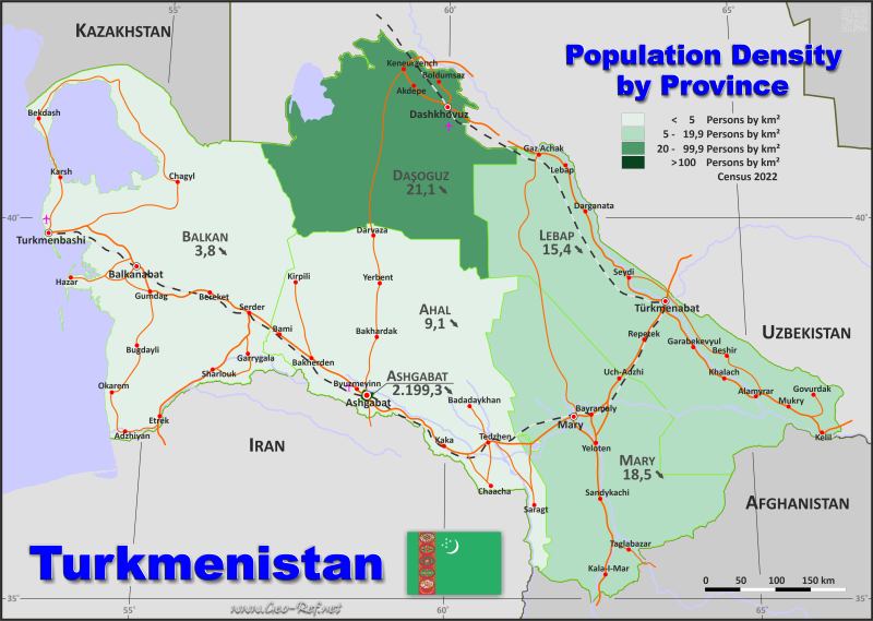
Country map - Administrative structure - Population density of Turkmenistan
Turkmenistan map - Click the map to get map as PDF file.
Other language versions are easy to generate, the descriptions are in own layers
Conditions for thematic maps with your own data and logotype
Delivery as printable file by e-mail or plot by post office
|
|---|
| Layers | |
| Provinces: | yes |
| Streets: | yes |
| Infrastructure: | yes |
| Rivers: | yes |
|
| Size | Till A2 |
| Delivery time | 7 working days | | Price |
| 1 bis 3 | 65 € | | > 3 | On request |
|
 |
All information published herein is free usable quoting the source,
including the maps, if they are not modified
|
|---|
Statistical data - Population density according to the administrative structure
The population data of the table below is census data from 2022, last available data.
Click on the column header brings the table in order of the column header.
The default order is the region name.
| Region |
ISO
3166-2 |
Capital |
Area
(km²) |
Population |
Density
(pers/km²) |
| Total |
|
|
488 150 |
7 057 841 |
14,5 |
|---|
| Last update: 01.06.2025 - 19:53:35 |
|---|
| Ahal |
TM-A |
Anau |
96 371 |
886 845 |
9,2 |
| Asgabat |
TM-S |
Asgabat |
980 |
1 030 063 |
1 051,1 |
| Balkan |
TM-B |
Balkanabat |
133 586 |
529 895 |
4,0 |
| Dasoguz |
TM-D |
Dasoguz |
73 521 |
1 550 354 |
21,1 |
| Lebap |
TM-L |
Türkmenabat |
96 469 |
1 447 298 |
15,0 |
| Mary |
TM-M |
Mary |
87 223 |
1 613 386 |
18,5 |
The regions are divided into districts, the data of which are shown in the table below.
| District |
Own |
Region |
Capital
| Area
(km²) |
Population |
Density
(pers/km²) |
| Total |
|
|
|
65 050 |
1 018 956 |
15,7 |
|---|
| Last update: 01.06.2025 - 19:53:35 |
|---|
| Ak bugday |
TM-A-01 |
Ahal |
Anau |
22 370 |
144 119 |
6,4 |
| Akdepe |
TM-D-01 |
Dasoguz |
Andalyp |
11 270 |
340 930 |
30,3 |
| Arkadag |
TM-A-02 |
Ahal |
Arkadag |
48 |
567 |
11,8 |
| Babadayhan |
TM-A-03 |
Ahal |
Babadayhan |
14 400 |
97 312 |
6,8 |
| Bagtyyarlyk |
TM-S-01 |
Asgabat |
Asgabat |
272 |
309 619 |
1 138,3 |
| Bäherden |
TM-A-04 |
Ahal |
Bäherden |
16 690 |
126 409 |
7,6 |
| Balkanabat |
TM-B-01 |
Balkan |
Balkanabat |
11 290 |
188 429 |
16,7 |
| Bayramaly |
TM-M-01 |
Mary |
Bayramaly |
10 390 |
70 376 |
6,8 |
| Bayramaly City |
TM-M-02 |
Mary |
Bayramaly |
29 |
170 462 |
5 878,0 |
| Bereket |
TM-B-02 |
Balkan |
Bereket |
22 110 |
39 282 |
1,8 |
| Berkararlyk |
TM-S-02 |
Asgabat |
Asgabat |
71 |
266 425 |
3 752,5 |
| Boldumsaz |
TM-D-02 |
Dasoguz |
Boldumsaz |
1 233 |
257 496 |
208,8 |
| Büzmeyin |
TM-S-03 |
Asgabat |
Asgabat |
449 |
175 179 |
390,2 |
| Cärjew |
TM-L-01 |
Lebap |
Cärjew |
30 490 |
233 699 |
7,7 |
| Dänew |
TM-L-02 |
Lebap |
Dänew |
6 089 |
159 634 |
26,2 |
| Darganata |
TM-L-03 |
Lebap |
Darganata |
14 890 |
57 952 |
3,9 |
| Dasoguz |
TM-D-03 |
Dasoguz |
Dasoguz |
161 |
201 142 |
1 249,3 |
| Esenguly |
TM-B-03 |
Balkan |
Esenguly |
9 801 |
45 436 |
4,6 |
| Etrek |
TM-B-04 |
Balkan |
Gyzyletrek |
10 680 |
23 747 |
2,2 |
| Garagum |
TM-M-03 |
Mary |
Yagtyyol |
2 452 |
62 218 |
25,4 |
| Gökdepe |
TM-A-05 |
Ahal |
Gökdepe |
16 010 |
161 819 |
10,1 |
| Görogly |
TM-D-04 |
Dasoguz |
Görogly |
14 800 |
164 894 |
11,1 |
| Gyzylarbat |
TM-B-05 |
Balkan |
Gyzylarbat |
9 852 |
72 473 |
7,4 |
| Halac |
TM-L-04 |
Lebap |
Halac |
1 800 |
133 909 |
74,4 |
| Hojambaz |
TM-L-05 |
Lebap |
Hojambaz |
7 978 |
110 376 |
13,8 |
| Kaka |
TM-A-06 |
Ahal |
Kaka |
10 620 |
93 652 |
8,8 |
| Kerki |
TM-L-06 |
Lebap |
Kerki |
17 550 |
132 562 |
7,6 |
| Köneürgenc |
TM-D-05 |
Dasoguz |
Köneürgenc |
1 318 |
176 784 |
134,1 |
| Köpetdag |
TM-S-04 |
Asgabat |
Asgabat |
188 |
278 840 |
1 483,2 |
| Köytendag |
TM-L-07 |
Lebap |
Köytendag |
6 623 |
199 820 |
30,2 |
| Magtymguly |
TM-B-06 |
Balkan |
Garrygala |
4 136 |
34 664 |
8,4 |
| Mary |
TM-M-04 |
Mary |
Mary |
1 352 |
167 027 |
123,5 |
| Mary City |
TM-M-05 |
Mary |
Mary |
83 |
173 140 |
2 086,0 |
| Murgap |
TM-M-06 |
Mary |
Murgap |
6 028 |
190 218 |
31,6 |
| Ruhubelent |
TM-D-06 |
Dasoguz |
Ruhubelent |
17 820 |
28 172 |
1,6 |
| Sabat |
TM-D-07 |
Dasoguz |
Sabat |
7 179 |
218 075 |
30,4 |
| Sakarcäge |
TM-M-07 |
Mary |
Sakarcäge |
11 480 |
196 202 |
17,1 |
| Saparmyrat Türkmenbasy |
TM-D-08 |
Dasoguz |
Saparmyrat Türkmenbasy |
19 740 |
162 861 |
8,3 |
| Sarahs |
TM-A-07 |
Ahal |
Sarahs |
5 963 |
81 006 |
13,6 |
| Sayat |
TM-L-08 |
Lebap |
Sayat |
10 890 |
188 485 |
17,3 |
| Tagtabazar |
TM-M-08 |
Mary |
Tagtabazar |
28 190 |
134 751 |
4,8 |
| Tejen |
TM-A-08 |
Ahal |
Tejen |
10 270 |
181 961 |
17,7 |
| Türkmenabat |
TM-L-09 |
Lebap |
Türkmenabat |
159 |
230 861 |
1 452,0 |
| Türkmenbasy |
TM-B-08 |
Balkan |
Türkmenbasy |
65 550 |
34 119 |
0,5 |
| Türkmenbasy City |
TM-B-07 |
Balkan |
Türkmenbasy |
167 |
91 745 |
549,4 |
| Türkmengala |
TM-M-09 |
Mary |
Türkmengala |
9 112 |
124 642 |
13,7 |
| Wekilbazar |
TM-M-10 |
Mary |
Mollanepes |
9 430 |
168 734 |
17,9 |
| Yolöten |
TM-M-11 |
Mary |
Yolöten |
8 677 |
155 616 |
17,9 |
Existing thematic maps
|
External links change quickly - If you get a link error - Please inform us!
 |
Membership in international organisations and treaties
Expand list
Political Alliances
Regional Unions
Military alliances/Arms control
Law enforcement
Business Alliances
Financial
Free Trade Area, Internal Market
Technical alliances
Transport
Cientific
Humanitarian Unions
Cultural Unions
|
|
If you have suggestions to include other information or you find missed links, please inform us!
Click here ... |
International Border disputes
Expand list
See also neighboring states
|
| |


