Democratic Socialist Republic of Sri Lanka
Country map - Administrative structure - Population density of Sri Lanka
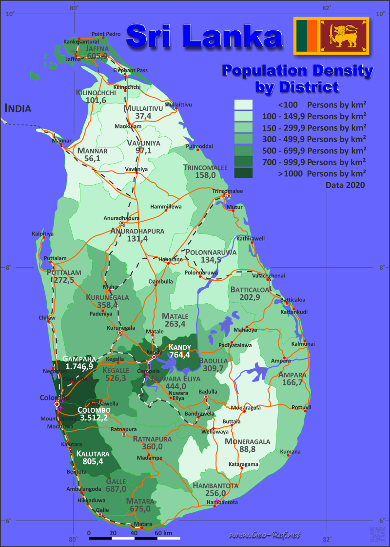
Sri Lanka map - Click the map to get map as PDF file.
Other language versions are easy to generate, the descriptions are in own layers
Conditions for thematic maps with your own data and logotype
Delivery as printable file by e-mail or plot by post office
|
|---|
| Layers | |
| Provinces: | yes |
| Streets: | yes |
| Infrastructure: | yes |
| Rivers: | yes |
|
| Size | Till A2 |
| Delivery time | 7 working days | | Price |
| 1 bis 3 | 75 € | | > 3 | On request |
|
 |
All information published herein is free usable quoting the source,
including the maps, if they are not modified
|
|---|
Statistical data - Population density according to the administrative structure
The population data of the table below is census data from 2024, last available data.
Click on the column header brings the table in order of the column header.
The default order is the province name.
| Province |
ISO
3166-2 |
Capital |
Area
(km²) |
Population |
Density
(pers/km²) |
| Total |
|
|
65 610 |
21 763 170 |
331,7 |
|---|
| Last update: 09.06.2025 - 03:01:59 |
|---|
| Central |
LK-2 |
Kandy |
5 674 |
2 712 804 |
478,1 |
| Eastern |
LK-5 |
Trincomalee |
9 996 |
1 782 050 |
178,3 |
| North Central |
LK-7 |
Anuradhapura |
10 472 |
1 406 890 |
134,3 |
| North Western |
LK-6 |
Kurunegala |
7 888 |
2 578 894 |
326,9 |
| Northern |
LK-4 |
Jaffna |
8 884 |
1 149 240 |
129,4 |
| Sabaragamuwa |
LK-9 |
Ratnapura |
4 968 |
2 015 039 |
405,6 |
| Southern |
LK-3 |
Galle |
5 544 |
2 605 506 |
470,0 |
| Uva |
LK-8 |
Badulla |
8 500 |
1 399 049 |
164,6 |
| Western |
LK-1 |
Colombo |
3 684 |
6 113 698 |
1 659,5 |
The provinces are subdivided into districts, illustrated in the next table.
| District |
ISO
3166-2 |
Province |
Capital
| Area
(km²) |
Population |
Density
(pers/km²) |
| Total |
|
|
|
65 610 |
21 763 170 |
331,7 |
|---|
| Last update: 09.06.2025 - 03:01:59 |
|---|
| Ampara |
LK-52 |
Eastern |
Ampara |
4 415 |
744 150 |
168,6 |
| Anuradhapura |
LK-71 |
North Central |
Anuradhapura |
7 179 |
959 552 |
133,7 |
| Badulla |
LK-81 |
Uva |
Badulla |
2 861 |
871 763 |
304,7 |
| Batticaloa |
LK-51 |
Eastern |
Batticaloa |
2 854 |
595 435 |
208,6 |
| Colombo |
LK-11 |
Western |
Colombo |
699 |
2 374 461 |
3 396,9 |
| Galle |
LK-31 |
Southern |
Galle |
1 652 |
1 096 585 |
663,8 |
| Gampaha |
LK-12 |
Western |
Gampaha |
1 387 |
2 433 685 |
1 754,6 |
| Hambantota |
LK-33 |
Southern |
Hambantota |
2 609 |
671 037 |
257,2 |
| Jaffna |
LK-41 |
Northern |
Jaffna |
1 025 |
594 333 |
579,8 |
| Kalutara |
LK-13 |
Western |
Kalutara |
1 598 |
1 305 552 |
817,0 |
| Kandy |
LK-21 |
Central |
Kandy |
1 940 |
1 461 269 |
753,2 |
| Kegalle |
LK-92 |
Sabaragamuwa |
Kegalle |
1 693 |
869 901 |
513,8 |
| Kilinochchi |
LK-42 |
Northern |
Kilinochchi |
1 279 |
136 434 |
106,7 |
| Kurunegala |
LK-61 |
North Western |
Kurunegala |
4 816 |
1 760 829 |
365,6 |
| Mannar |
LK-43 |
Northern |
Mannar |
1 996 |
123 674 |
62,0 |
| Matale |
LK-22 |
Central |
Matale |
1 993 |
526 578 |
264,2 |
| Matara |
LK-32 |
Southern |
Matara |
1 283 |
837 884 |
653,1 |
| Moneragala |
LK-82 |
Uva |
Moneragala |
5 639 |
527 286 |
93,5 |
| Mullaitivu |
LK-45 |
Northern |
Mullaitivu |
2 617 |
122 542 |
46,8 |
| Nuwara Eliya |
LK-23 |
Central |
Nuwara Eliya |
1 741 |
724 957 |
416,4 |
| Polonnaruwa |
LK-72 |
North Central |
Polonnaruwa |
3 293 |
447 338 |
135,8 |
| Puttalam |
LK-62 |
North Western |
Puttalam |
3 072 |
818 065 |
266,3 |
| Ratnapura |
LK-91 |
Sabaragamuwa |
Ratnapura |
3 275 |
1 145 138 |
349,7 |
| Trincomalee |
LK-53 |
Eastern |
Trincomalee |
2 727 |
442 465 |
162,3 |
| Vavuniya |
LK-44 |
Northern |
Vavuniya |
1 967 |
172 257 |
87,6 |
Existing thematic maps
|
External links change quickly - If you get a link error - Please inform us!
 |
Membership in international organisations and treaties
Expand list
Political Alliances
Regional Unions
Military alliances/Arms control
Law enforcement
Business Alliances
Fishery
Financial
Free Trade Area, Internal Market
Technical alliances
Transport
Cientific
Humanitarian Unions
Cultural Unions
|
|
If you have suggestions to include other information or you find missed links, please inform us!
Click here ... |
International Border disputes
Expand list
See also neighboring states
|
| |


