Autonomous Region of Azores
| Capital |
Currency | Government system |
|---|
| Ponta Delgada |
Euro (EUR) |
Dependent from Portugal |
| Official language | Region |
Population |
|---|
| Portuguese |
Europe |
Estimation 2025
241 718 |
Country map - Administrative structure - Population density of Azores
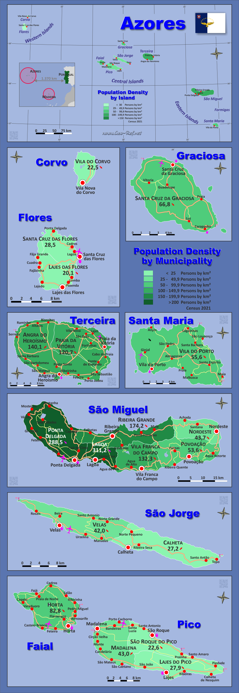
Azores map - Click the map to get map as PDF file.
Other language versions are easy to generate, the descriptions are in own layers
Conditions for thematic maps with your own data and logotype
Delivery as printable file by e-mail or plot by post office
|
|---|
| Layers | |
| Provinces: | yes |
| Streets: | yes |
| Infrastructure: | yes |
| Rivers: | yes |
|
| Size | Till A2 |
| Delivery time | 7 working days | | Price |
| 1 bis 3 | 65 € | | > 3 | On request |
|
 |
All information published herein is free usable quoting the source,
including the maps, if they are not modified
|
|---|
Statistical data - Population density according to the administrative structure
The population data of the table below is an estimation form 2025, based on the census 2021.
Click on the column header brings the table in order of the column header.
The default order is the island name.
| Island |
ISO
3166-2 |
Capital |
Area
(km²) |
Population |
Density
(pers/km²) |
| Total |
|
|
2 322 |
241 718 |
104,1 |
|---|
| Last update: 10/24/2025 - 13:50:45 |
|---|
| Corvo |
PT-COR |
Vila do Corvo |
17,1 |
437 |
25,5 |
| Faial |
PT-FAI |
Horta |
173,0 |
14 466 |
83,6 |
| Flores |
PT-FLO |
Santa Cruz das Flores |
141,0 |
3 570 |
25,3 |
| Graciosa |
PT-GRA |
Santa Cruz da Graciosa |
60,7 |
4 070 |
67,1 |
| Pico |
PT-PIC |
Magdalena |
444,8 |
14 418 |
32,4 |
| Santa Maria |
PT-SMA |
Vila do Porto |
96,9 |
5 504 |
56,8 |
| São Jorge |
PT-SJO |
Velas |
243,7 |
8 435 |
34,6 |
| São Miguel |
PT-SMI |
Ponta Delgada |
744,5 |
137 255 |
184,3 |
| Terceira |
PT-TER |
Angra do Heroísmo |
400,3 |
53 563 |
133,8 |
The following table shows the subdivision of the islands by parish.
| Community |
ZIP |
Island |
Capital
| Area
(km²) |
Population |
Density
(pers/km²) |
| Total |
|
|
|
2 322 |
241 718 |
104,1 |
|---|
| Last update: 10/24/2025 - 13:50:45 |
|---|
| Angra do Heroísmo |
9701 |
Terceira |
Angra do Heroísmo |
239,0 |
33 701 |
141,0 |
| Calheta |
9850 |
São Jorge |
Calheta |
126,3 |
3 486 |
27,6 |
| Horta |
9900 |
Faial |
Horta |
173,0 |
14 466 |
83,6 |
| Lagoa |
9560 |
São Miguel |
Lagoa |
45,6 |
15 130 |
331,8 |
| Lajes das Flores |
9960 |
Flores |
Lajes das Flores |
70,0 |
1 456 |
20,8 |
| Lajes do Pico |
9930 |
Pico |
Lajes do Pico |
155,3 |
4 398 |
28,3 |
| Madalena |
9950 |
Pico |
Madalena |
147,1 |
6 559 |
44,6 |
| Nordeste |
9630 |
São Miguel |
Nordeste |
101,5 |
4 439 |
43,8 |
| Ponta Delgada |
9500 |
São Miguel |
Ponta Delgada |
233,0 |
69 038 |
296,3 |
| Povoação |
9650 |
São Miguel |
Povoação |
106,4 |
5 883 |
55,3 |
| Praia da Vitória |
9760 |
Terceira |
Praia da Vitória |
161,3 |
19 862 |
123,2 |
| Ribeira Grande |
9600 |
São Miguel |
Ribeira Grande |
180,1 |
32 397 |
179,8 |
| Santa Cruz da Graciosa |
9880 |
Graciosa |
Santa Cruz da Graciosa |
60,7 |
4 070 |
67,1 |
| Santa Cruz das Flores |
9970 |
Flores |
Santa Cruz das Flores |
70,9 |
2 114 |
29,8 |
| São Roque do Pico |
9940 |
Pico |
São Roque do Pico |
142,4 |
3 461 |
24,3 |
| Velas |
9800 |
São Jorge |
Velas |
117,4 |
4 949 |
42,2 |
| Vila do Corvo |
9908 |
Corvo |
Vila do Corvo |
17,1 |
437 |
25,5 |
| Vila do Porto |
9580 |
Santa Maria |
Vila do Porto |
96,9 |
5 504 |
56,8 |
| Vila Franca do Campo |
9680 |
São Miguel |
Vila Franca do Campo |
78,0 |
10 368 |
133,0 |
Existing thematic maps
|
External links change quickly - If you get a link error - Please inform us!
 |
See also neighboring states
|


