Turks & Caicos Islands
| Capital |
Currency | Government system |
|---|
| Cockburn Town |
Pound Sterling (GBP) |
Dependent from UK |
| Official language | Region |
Population |
|---|
| English |
Central America & Caribbean |
Estimation 2024
60 150 |
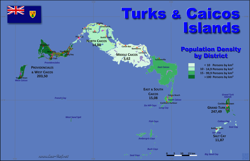
Country map - Administrative structure - Population density of Turks & Caicos Islands
Turks & Caicos Islands map - Click the map to get map as PDF file.
Other language versions are easy to generate, the descriptions are in own layers
Conditions for thematic maps with your own data and logotype
Delivery as printable file by e-mail or plot by post office
|
|---|
| Layers | |
| Provinces: | yes |
| Streets: | yes |
| Infrastructure: | yes |
| Rivers: | yes |
|
| Size | Till A2 |
| Delivery time | 7 working days | | Price |
| 1 bis 3 | 65 € | | > 3 | On request |
|
 |
All information published herein is free usable quoting the source,
including the maps, if they are not modified
|
|---|
Statistical data - Population density according to the administrative structure
The population data of the table below is an estimation form 2024, based on the census 2012.
Click on the column header brings the table in order of the column header.
The default order is the district name.
| District |
ISO
3166-2 |
Capital |
Area
(km²) |
Population |
Density
(pers/km²) |
| Total |
|
|
588,9 |
60 150 |
102,14 |
|---|
| Last update: 01/02/2026 - 19:46:00 |
|---|
| Grand Turk |
TC-GT |
Cockburn Town |
18,0 |
5 150 |
286,11 |
| Middle Caicos |
TC-MC |
Conch Bar |
144,2 |
770 |
5,34 |
| North Caicos |
TC-NC |
Bottle Creek |
144,9 |
3 190 |
22,02 |
| Providenciales and West Caicos |
TC-PR |
Blue Hills |
163,6 |
49 300 |
301,34 |
| Salt Cay |
TC-SL |
Balfour Town |
6,4 |
50 |
7,81 |
| South Caicos and East Caicos |
TC-SC |
Cockburn Harbour |
111,8 |
1 690 |
15,12 |
Existing thematic maps
|
External links change quickly - If you get a link error - Please inform us!
 |
Membership in international organisations and treaties
Expand list
Political Alliances
Regional Unions
Law enforcement
Financial
Technical alliances
Humanitarian Unions
|
|
If you have suggestions to include other information or you find missed links, please inform us!
Click here ... |
See also neighboring states
|


