Republic of Malta
| Capital |
Currency | Government system |
|---|
| Valletta |
Euro (EUR) |
Parliamentary democracy |
| Official language | Region |
Population |
|---|
Maltese
English |
Europe |
Estimation 2024
563 443 |
Country map - Administrative structure - Population density of Malta
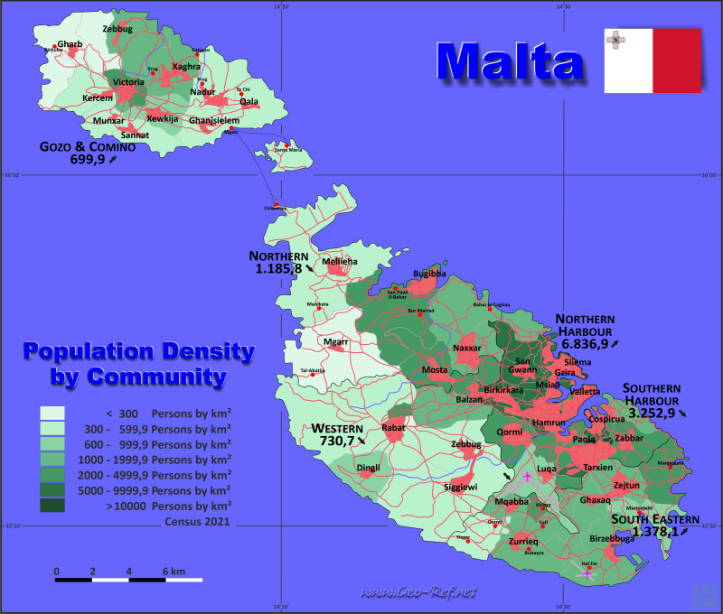
Malta map - Click the map to get map as PDF file.
Other language versions are easy to generate, the descriptions are in own layers
Conditions for thematic maps with your own data and logotype
Delivery as printable file by e-mail or plot by post office
|
|---|
| Layers | |
| Provinces: | yes |
| Streets: | yes |
| Infrastructure: | yes |
| Rivers: | yes |
|
| Size | Till A2 |
| Delivery time | 7 working days | | Price |
| 1 bis 3 | 80 € | | > 3 | On request |
|
 |
All information published herein is free usable quoting the source,
including the maps, if they are not modified
|
|---|
Statistical data - Population density according to the administrative structure
The population data of the table below is census data from 2021, last available data.
There are no ISO codes for the regions, these are set at the district level - in the second table. The regions are formulated as statistical units.
Click on the column header brings the table in order of the column header.
The default order is the region name.
| Region |
HASC |
Island |
Capital |
Area
(km²) |
Population |
Density
(pers/km²) |
| Total |
|
|
|
315,2 |
563 443 |
1 787,6 |
|---|
| Last update: 02.02.2025 - 20:17:56 |
|---|
| Gozo & Comino |
MT.GO |
Gozo & Comino |
Victoria |
63,6 |
40 926 |
643,5 |
| Northern |
MT.NO |
Malta |
Mosta |
73,6 |
104 664 |
1 422,1 |
| Northern Harbour |
MT.CE |
Malta |
Qormi |
25,1 |
177 848 |
7 085,6 |
| South Eastern |
MT.SE |
Malta |
Zejtun |
54,3 |
81 869 |
1 507,7 |
| Southern Harbour |
MT.SO |
Malta |
Valletta |
26,1 |
89 462 |
3 427,7 |
| Western |
MT.WE |
Malta |
Zebbug |
72,5 |
68 674 |
947,2 |
The regions are divided into districts, which are shown in the following table in their assignment to the regions.
| District |
ISO 3166-2 |
Region |
Capital
| Area
(km²) |
Population |
Density
(pers/km²) |
| Total |
|
|
|
315,2 |
563 443 |
1 787,6 |
|---|
| Last update: 02.02.2025 - 20:17:56 |
|---|
| Attard |
MT-01 |
Western |
Attard |
6,6 |
12 952 |
1 962,4 |
| Balzan |
MT-02 |
Western |
Balzan |
0,6 |
4 977 |
8 295,0 |
| Birgu |
MT-03 |
Southern Harbour |
Birgu |
0,5 |
2 265 |
4 530,0 |
| Birkirkara |
MT-04 |
Northern Harbour |
Birkirkara |
2,7 |
28 841 |
10 681,9 |
| Birzebbuga |
MT-05 |
South Eastern |
Birzebbuga |
9,2 |
12 404 |
1 348,3 |
| Bormla |
MT-06 |
Southern Harbour |
Cospicua |
0,9 |
4 782 |
5 313,3 |
| Dingli |
MT-07 |
Western |
Dingli |
5,7 |
3 906 |
685,3 |
| Fgura |
MT-08 |
Southern Harbour |
Fgura |
1,1 |
13 861 |
12 600,9 |
| Fontana |
MT-10 |
Gozo & Comino |
Fontana |
0,5 |
1 150 |
2 300,0 |
| Furjana |
MT-09 |
Southern Harbour |
Floriana |
0,9 |
2 072 |
2 302,2 |
| Ghajnsielem |
MT-13 |
Gozo & Comino |
Ghajnsielem |
7,2 |
3 721 |
516,8 |
| Gharb |
MT-14 |
Gozo & Comino |
Gharb |
4,6 |
1 585 |
344,6 |
| Gharghur |
MT-15 |
Northern |
Gharghur |
2,0 |
3 947 |
1 973,5 |
| Ghasri |
MT-16 |
Gozo & Comino |
Ghasri |
5,0 |
519 |
103,8 |
| Ghaxaq |
MT-17 |
South Eastern |
Ghaxaq |
3,9 |
5 791 |
1 484,9 |
| Gudja |
MT-11 |
South Eastern |
Gudja |
2,3 |
3 440 |
1 495,7 |
| Gzira |
MT-12 |
Northern Harbour |
Gzira |
1,5 |
12 158 |
8 105,3 |
| Hamrun |
MT-18 |
Northern Harbour |
Hamrun |
1,1 |
11 751 |
10 682,7 |
| Iklin |
MT-19 |
Western |
Iklin |
1,7 |
3 648 |
2 145,9 |
| Imdina |
MT-29 |
Western |
Notabile |
0,9 |
199 |
221,1 |
| Imgarr |
MT-31 |
Northern |
Imgarr |
16,1 |
5 110 |
317,4 |
| Imqabba |
MT-33 |
South Eastern |
Imqabba |
2,6 |
3 653 |
1 405,0 |
| Imsida |
MT-34 |
Northern Harbour |
Imsida |
1,7 |
15 815 |
9 302,9 |
| Imtarfa |
MT-35 |
Western |
Imtarfa |
0,7 |
2 564 |
3 662,9 |
| Kalkara |
MT-21 |
Southern Harbour |
Kalkara |
1,8 |
3 224 |
1 791,1 |
| Kercem |
MT-22 |
Gozo & Comino |
Kercem |
5,5 |
1 922 |
349,5 |
| Kirkop |
MT-23 |
South Eastern |
Kirkop |
1,1 |
2 599 |
2 362,7 |
| Lija |
MT-24 |
Western |
Lija |
1,1 |
3 740 |
3 400,0 |
| Luqa |
MT-25 |
Southern Harbour |
Luqa |
6,7 |
7 335 |
1 094,8 |
| Marsa |
MT-26 |
Southern Harbour |
Marsa |
2,8 |
5 861 |
2 093,2 |
| Marsaskala |
MT-27 |
South Eastern |
Marsaskala |
5,4 |
18 253 |
3 380,2 |
| Marsaxlokk |
MT-28 |
South Eastern |
Marsaxlokk |
4,7 |
4 145 |
881,9 |
| Mellieha |
MT-30 |
Northern |
Mellieha |
22,6 |
14 004 |
619,6 |
| Mosta |
MT-32 |
Northern |
Mosta |
6,8 |
25 152 |
3 698,8 |
| Munxar |
MT-36 |
Gozo & Comino |
Munxar |
2,8 |
1 861 |
664,6 |
| Nadur |
MT-37 |
Gozo & Comino |
Nadur |
7,2 |
4 613 |
640,7 |
| Naxxar |
MT-38 |
Northern |
Naxxar |
11,6 |
17 836 |
1 537,6 |
| Paola |
MT-39 |
Southern Harbour |
Paola |
2,5 |
9 789 |
3 915,6 |
| Pembroke |
MT-40 |
Northern Harbour |
Pembroke |
2,3 |
3 725 |
1 619,6 |
| Pieta |
MT-41 |
Northern Harbour |
Pieta |
0,5 |
6 901 |
13 802,0 |
| Qala |
MT-42 |
Gozo & Comino |
Qala |
5,9 |
2 340 |
396,6 |
| Qormi |
MT-43 |
Northern Harbour |
Pinto |
5,0 |
19 567 |
3 913,4 |
| Qrendi |
MT-44 |
South Eastern |
Qrendi |
4,9 |
3 263 |
665,9 |
| Rabat |
MT-45 |
Western |
Rabat |
26,6 |
12 284 |
461,8 |
| Safi |
MT-47 |
South Eastern |
Safi |
2,3 |
2 934 |
1 275,7 |
| San Giljan |
MT-48 |
Northern Harbour |
San Giljan |
1,6 |
14 524 |
9 077,5 |
| San Gwann |
MT-49 |
Northern Harbour |
San Gwann |
2,6 |
15 697 |
6 037,3 |
| San Lawrenz |
MT-50 |
Gozo & Comino |
San Lawrenz |
3,6 |
797 |
221,4 |
| San Pawl il-Bahar |
MT-51 |
Northern |
San Pawl il-Bahar |
14,5 |
38 615 |
2 663,1 |
| Sannat |
MT-52 |
Gozo & Comino |
Sannat |
3,8 |
2 254 |
593,2 |
| Santa Lucija |
MT-53 |
Southern Harbour |
Santa Lucija |
0,7 |
2 642 |
3 774,3 |
| Santa Venera |
MT-54 |
Northern Harbour |
Santa Venera |
0,9 |
9 577 |
10 641,1 |
| Senglea (Isla) |
MT-20 |
Southern Harbour |
Senglea |
0,2 |
2 384 |
11 920,0 |
| Siggiewi |
MT-55 |
Western |
Ferdinand |
19,9 |
9 652 |
485,0 |
| Sliema |
MT-56 |
Northern Harbour |
Sliema |
1,3 |
22 037 |
16 951,5 |
| Swieqi |
MT-57 |
Northern Harbour |
Swieqi |
3,1 |
14 794 |
4 772,3 |
| Ta´Xbiex |
MT-58 |
Northern Harbour |
Ta´Xbiex |
0,8 |
2 461 |
3 076,3 |
| Tarxien |
MT-59 |
Southern Harbour |
Tarxien |
0,9 |
9 876 |
10 973,3 |
| Valletta |
MT-60 |
Southern Harbour |
Valletta |
0,8 |
5 201 |
6 501,3 |
| Victoria |
MT-46 |
Gozo & Comino |
Victoria |
2,9 |
7 477 |
2 578,3 |
| Xaghra |
MT-61 |
Gozo & Comino |
Xaghra |
2,5 |
5 337 |
2 134,8 |
| Xewkija |
MT-62 |
Gozo & Comino |
Xewkija |
4,5 |
3 675 |
816,7 |
| Xghajra |
MT-63 |
Southern Harbour |
Xghajra |
1,0 |
2 416 |
2 416,0 |
| Zabbar |
MT-64 |
Southern Harbour |
Hompesch |
5,3 |
17 754 |
3 349,8 |
| Zebbug |
MT-66 |
Western |
Rohan |
8,7 |
14 752 |
1 695,6 |
| Zebbug (Gonzo) |
MT-65 |
Gozo & Comino |
Zebbug |
7,6 |
3 675 |
483,6 |
| Zejtun |
MT-67 |
South Eastern |
Beland |
7,4 |
12 719 |
1 718,8 |
| Zurrieq |
MT-68 |
South Eastern |
Zurrieq |
10,5 |
12 668 |
1 206,5 |
Existing thematic maps
|
External links change quickly - If you get a link error - Please inform us!
 |
Membership in international organisations and treaties
Expand list
Political Alliances
Regional Unions
Military alliances/Arms control
Law enforcement
Business Alliances
Financial
Free Trade Area, Internal Market
Technical alliances
Transport
Cientific
Humanitarian Unions
Cultural Unions
|
|
If you have suggestions to include other information or you find missed links, please inform us!
Click here ... |
International Border disputes
Expand list
See also neighboring states
|
| |


