Jamaica
| Capital |
Currency | Government system |
|---|
| Kingston |
Jamaican Dollar (JMD) |
Constitutional hereditary monarchy |
| Official language | Region |
Population |
|---|
| English |
Central America & Caribbean |
Census 2022
|
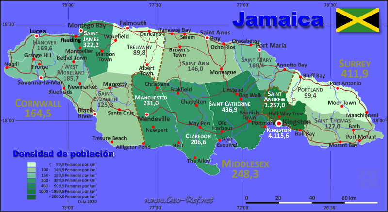
Country map - Administrative structure - Population density of Jamaica
Jamaica map - Click the map to get map as PDF file.
Other language versions are easy to generate, the descriptions are in own layers
Conditions for thematic maps with your own data and logotype
Delivery as printable file by e-mail or plot by post office
|
|---|
| Layers | |
| Provinces: | yes |
| Streets: | yes |
| Infrastructure: | yes |
| Rivers: | yes |
|
| Size | Till A2 |
| Delivery time | 7 working days | | Price |
| 1 bis 3 | 60 € | | > 3 | On request |
|
 |
All information published herein is free usable quoting the source,
including the maps, if they are not modified
|
|---|
Statistical data - Population density according to the administrative structure
The population data of the table below is an estimation form , based on the census 2022.
Click on the column header brings the table in order of the column header.
The default order is the county name.
| County |
ISO
3166-2 |
Capital |
Area
(km²) |
Population |
Density
(pers/km²) |
| Total |
|
|
|
|
|
|---|
| Last update: 11/04/202 - 00:44:05 |
|---|
| Total |
|
|
10 994 |
2 774 538 |
252,4 |
| Cornwall |
JM-CO |
Montego Bay |
3 918 |
635 269 |
162,1 |
| Middlesex |
JM-MI |
Spanish Town |
5 042 |
1 286 908 |
255,2 |
| Surrey |
JM-SU |
Kingston |
2 034 |
852 361 |
419,1 |
The following table shows the counties divided by parishs There are no subdivision for the parishs defined in ISO 3166.
| Parish |
ISO
3166-2 |
County |
Capital
| Area
(km²) |
Population |
Density
(pers/km²) |
| Total |
|
|
|
10 994 |
2 774 538 |
252,4 |
|---|
| Last update: 11/04/202 - 00:44:05 |
|---|
| Clarendon |
JM-13 |
Middlesex |
May Pen |
1 196 |
258 643 |
216,3 |
| Hanover |
JM-09 |
Cornwall |
Lucea |
430 |
69 780 |
162,3 |
| Kingston |
JM-01 |
Surrey |
Kingston |
22 |
89 186 |
4 053,9 |
| Manchester |
JM-12 |
Middlesex |
Mandeville |
830 |
193 694 |
233,4 |
| Portland |
JM-04 |
Surrey |
Port Antonio |
814 |
84 972 |
104,4 |
| Saint Andrew |
JM-02 |
Surrey |
Kingston |
455 |
583 718 |
1 282,9 |
| Saint Ann |
JM-06 |
Middlesex |
Saint Ann’s Bay |
1 213 |
175 310 |
144,5 |
| Saint Catherine |
JM-14 |
Middlesex |
Spanish Town |
1 192 |
542 763 |
455,3 |
| Saint Elizabeth |
JM-11 |
Cornwall |
Black River |
1 212 |
153 201 |
126,4 |
| Saint James |
JM-08 |
Cornwall |
Montego Bay |
595 |
188 656 |
317,1 |
| Saint Mary |
JM-05 |
Middlesex |
Port Maria |
611 |
116 498 |
190,7 |
| Saint Thomas |
JM-03 |
Surrey |
Morant Bay |
743 |
94 485 |
127,2 |
| Trelawny |
JM-07 |
Cornwall |
Falmouth |
874 |
77 427 |
88,6 |
| Westmoreland |
JM-10 |
Cornwall |
Savanna-la-Mar |
807 |
146 205 |
181,2 |
Existing thematic maps
Population density Mordrate 2013
|
External links change quickly - If you get a link error - Please inform us!
 |
Membership in international organisations and treaties
Expand list
Political Alliances
Regional Unions
Military alliances/Arms control
Law enforcement
Business Alliances
Financial
Free Trade Area, Internal Market
Technical alliances
Transport
Cientific
Humanitarian Unions
Cultural Unions
|
|
If you have suggestions to include other information or you find missed links, please inform us!
Click here ... |
International Border disputes
Expand list
See also neighboring states
|
| |


